SUMMARY
This is AI generated summarization, which may have errors. For context, always refer to the full article.
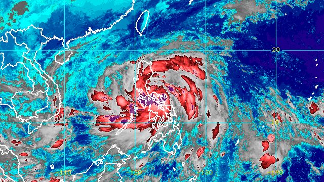
MANILA, Philippines – Severe Tropical Storm Paeng (Nalgae) made its third landfall in Buenavista, Quezon, at 6 am on Saturday, October 29.
Its first two landfalls were in Virac, Catanduanes, at 1:10 am, and Caramoan, Camarines Sur, at 1:40 am.
The municipality of Buenavista is part of the Bondoc Peninsula in the southern part of Quezon province.
In a bulletin released shortly before 9 am, the Philippine Atmospheric, Geophysical, and Astronomical Services Administration (PAGASA) said Paeng has since crossed the Bondoc Peninsula and is already over the coastal waters of Catanauan, Quezon.
The severe tropical storm continues to move west northwest at a relatively fast 30 kilometers per hour (km/h).
It is heading for Marinduque, where it could make another landfall on Saturday morning. Then it may cross the Calabarzon-Metro Manila-Bataan area for the rest of Saturday until early Sunday morning, October 30.
PAGASA noted, however, that Paeng’s track may still shift southward.
Paeng continued to have maximum sustained winds of 95 km/h and gustiness of up to 160 km/h early Saturday morning.
It may weaken into a tropical storm within 24 hours or earlier while crossing land, then re-intensify into a severe tropical storm once it reaches the West Philippine Sea.
Most of the areas remaining in Paeng’s path have been upgraded to Signal No. 3, including Metro Manila. Here is the full list of areas under tropical cyclone wind signals as of 8 am on Saturday:
Signal No. 3
Storm-force winds (89 to 117 km/h), moderate to significant threat to life and property
- Camarines Norte
- western part of Camarines Sur (Del Gallego, Ragay, Lupi, Sipocot, Cabusao, Pasacao, Libmanan, Pamplona)
- Marinduque
- Quezon including Polillo Islands
- Laguna
- Batangas
- Cavite
- Rizal
- Metro Manila
Signal No. 2
Gale-force winds (62 to 88 km/h), minor to moderate threat to life and property
- Catanduanes
- Albay
- western part of Sorsogon (Pilar, Castilla, Donsol)
- western part of Masbate (Aroroy, Baleno, Mandaon) including Burias Island
- southern part of Aurora (San Luis, Baler, Dingalan, Maria Aurora)
- Bulacan
- Pampanga
- Bataan
- Tarlac
- Zambales
- Nueva Ecija
- Pangasinan
- rest of Camarines Sur
- Romblon
- Oriental Mindoro
- Occidental Mindoro including Lubang Islands
Signal No. 1
Strong winds (39 to 61 km/h), minimal to minor threat to life and property
- Isabela
- Nueva Vizcaya
- Quirino
- Kalinga
- Ifugao
- Mountain Province
- Benguet
- Ilocos Sur
- La Union
- rest of Aurora
- rest of Sorsogon
- rest of Masbate including Ticao Island
- northern part of Palawan (El Nido, Taytay, Dumaran, Araceli, Roxas, San Vicente) including Calamian and Cuyo Islands
- Northern Samar
- Samar
- Eastern Samar
- Biliran
- Leyte
- Southern Leyte
- Cebu including Bantayan and Camotes Islands
- Bohol
- Negros Occidental
- Negros Oriental
- Guimaras
- Aklan
- Antique
- Capiz
- Iloilo
Meanwhile, the surge of the northeast monsoon or hanging amihan enhanced by Paeng is bringing strong winds to these areas:
- Batanes
- Babuyan Islands
- northern and eastern parts of mainland Cagayan
- Ilocos Norte
- northern part of Apayao
PAGASA maintained its rainfall forecast for the next 24 hours. Widespread floods and landslides remain likely as Paeng continues to trigger rain in large swathes of the country.
Until Saturday morning, October 29
Heavy to intense rain, with at times torrential rain
- Bicol
- Quezon including Polillo Islands
- Marinduque
- Romblon
- Occidental Mindoro
- Oriental Mindoro
- northern part of Palawan including Calamian and Cuyo Islands
- Aklan
- Antique
- Capiz
- Iloilo
- Guimaras
Moderate to heavy rain, with at times intense rain
- Metro Manila
- rest of Calabarzon
- eastern part of mainland Cagayan Valley
- Aurora
- Bulacan
- rest of Palawan
- Negros Occidental
- Northern Samar
Light to moderate rain, with at times heavy rain
- Cordillera Administrative Region
- rest of Cagayan Valley
- rest of Central Luzon
- rest of Visayas
- Zamboanga Peninsula
Saturday morning to evening, October 29
Heavy to intense rain, with at times torrential rain
- Metro Manila
- Calabarzon
- Marinduque
- Romblon
- Occidental Mindoro
- Oriental Mindoro
- northern part of Palawan including Calamian and Cuyo Islands
Moderate to heavy rain, with at times intense rain
- mainland Cagayan Valley
- Cordillera Administrative Region
- Aurora
- Nueva Ecija
- Pampanga
- Bulacan
- Bataan
- Camarines Norte
- Camarines Sur
- Western Visayas
Light to moderate rain, with at times heavy rain
- Ilocos Region
- rest of Central Luzon
- rest of Bicol
- rest of Visayas
Saturday evening, October 29, to Sunday morning, October 30
Heavy to intense rain, with at times torrential rain
- Metro Manila
- Zambales
- Bataan
- Tarlac
- Pampanga
- Bulacan
- Rizal
- Laguna
- Cavite
- Batangas
Moderate to heavy rain, with at times intense rain
- mainland Cagayan Valley
- Cordillera Administrative Region
- Quezon including Polillo Islands
- Marinduque
- Occidental Mindoro
- Oriental Mindoro
- rest of Central Luzon
- Western Visayas
Light to moderate rain, with at times heavy rain
- Ilocos Region
- Camarines Norte
- Camarines Sur
- Romblon
- northern part of Palawan including Calamian and Cuyo Islands

PAGASA also warned that there is a minimal to moderate risk of storm surges up to 2 meters high, which may cause floods in the “low-lying and exposed coastal areas” of the following:
- western part of Pangasinan
- Zambales
- Bataan
- southern part of Aurora
- Quezon including Polillo Islands
- Bulacan
- Metro Manila
- Cavite
- Batangas
- Marinduque
- Camarines Norte
- Camarines Sur
- Albay
The gale warning issued at 5 am on Saturday remains in effect as Paeng and the northeast monsoon affect the country’s coastal waters.
- seaboards of Central Luzon and Southern Luzon and eastern seaboard of Visayas (Aurora, Zambales, Bataan, Pampanga, Bulacan, Metro Manila, Cavite, Batangas, Quezon including Polillo Islands, Occidental Mindoro including Lubang Islands, Oriental Mindoro, Marinduque, Romblon, Camarines Norte, Camarines Sur, Catanduanes, Albay, Sorsogon, Masbate including Burias Island and Ticao Island, Northern Samar, Eastern Samar) – very rough to high seas, waves 4.5 to 8 meters high
- seaboards of Northern Luzon (Batanes, Cagayan including Babuyan Islands, Isabela, Ilocos Norte, Ilocos Sur, La Union, Pangasinan) – very rough seas, waves 4.5 to 6 meters high
- seaboards of Visayas and Palawan (Aklan, Antique. Capiz, Iloilo, Guimaras, Negros Occidental, Negros Oriental, Cebu, Bohol, Siquijor, Samar, Biliran, Leyte, Southern Leyte, Palawan including Calamian, Cuyo, Kalayaan Islands) – rough to very rough seas, waves 3.1 to 5.5 meters high
- eastern seaboards of Mindanao (Surigao del Norte including Siargao and Bucas Grande Islands, Dinagat Islands, Surigao del Sur, eastern coast of Davao Oriental) – rough to very rough seas, waves 2.8 to 4.5 meters high
“Rough to high sea conditions are risky for all types of sea vessels. Mariners are advised to remain in port or take shelter in port until winds and waves subside,” PAGASA said.
Paeng is the Philippines’ 16th tropical cyclone for 2022 and the fourth for October. PAGASA earlier said there may be up to four tropical cyclones during the month.
There may be a fifth tropical cyclone in October, however, as the low pressure area outside the Philippine Area of Responsibility (PAR) just developed into a tropical depression.
The tropical depression was located 1,485 kilometers east of Mindanao before dawn on Saturday, moving west at 35 km/h.
It has maximum sustained winds of 45 km/h and gustiness of up to 55 km/h.
PAGASA Weather Specialist Benison Estareja said the tropical depression may enter PAR on Monday, October 31. If it does, it would be given the local name Queenie.
Further updates are expected in the coming days. – Rappler.com
Add a comment
How does this make you feel?


There are no comments yet. Add your comment to start the conversation.