SUMMARY
This is AI generated summarization, which may have errors. For context, always refer to the full article.
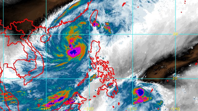
MANILA, Philippines – Severe Tropical Storm Paeng (Nalgae) left the Philippine Area of Responsibility (PAR) at 12:10 pm on Monday, October 31, but it continues to affect parts of Luzon and Western Visayas.
Meanwhile, Tropical Storm Queenie (Banyan) accelerated on Monday afternoon.
Paeng
In a briefing around 6 pm on Monday, the Philippine Atmospheric, Geophysical, and Astronomical Services Administration (PAGASA) said Paeng was already 400 kilometers west of Sinait, Ilocos Sur, moving north northwest outside PAR at a slightly faster 15 kilometers per hour from the previous 10 km/h.
The severe tropical storm is expected to move north in the next 12 hours before gradually turning northwest to west northwest toward the southern part of China.
Paeng also intensified further on Monday afternoon. Its maximum sustained winds increased from 95 km/h to 110 km/h, while its gustiness is now up to 135 km/h from the previous 115 km/h.
PAGASA said Paeng may strengthen into a typhoon on Monday evening or early Tuesday morning, November 1. After it reaches its peak intensity, it could start weakening by Wednesday, November 2.
Despite Paeng’s exit from PAR, it may still cause rain until early Tuesday morning due to its wide circulation.
Moderate to heavy rain
- Batanes
- Zambales
- Bataan
Light to moderate rain, with at times heavy rain
- Ilocos Region
- Cordillera Administrative Region
- Mimaropa
- rest of Central Luzon
- Babuyan Islands
- Cavite
- Batangas
- southern part of Quezon
- Western Visayas
PAGASA warned that floods and landslides remain possible.
Some areas also remain under Signal No. 1, which means they may continue to have strong winds:
- Abra
- western part of Benguet (Tuba, Baguio City, Kapangan, Atok, Kibungan, La Trinidad, Sablan, Tublay, Bakun)
- southern part of Ilocos Norte (Badoc, Pinili, Banna, Nueva Era, Batac City, Paoay, Marcos, Currimao, Dingras, Solsona, Sarrat, San Nicolas, Laoag City, Piddig)
- Ilocos Sur
- La Union
- central and western parts of Pangasinan (Basista, Lingayen, Villasis, Alaminos City, Anda, Malasiqui, San Fabian, Urbiztondo, Bautista, Mangaldan, Mapandan, Burgos, Dagupan City, Binalonan, Bolinao, Aguilar, Alcala, Sual, Labrador, Bani, Santo Tomas, Pozorrubio, Urdaneta City, Laoac, Mangatarem, Mabini, San Carlos City, Manaoag, Binmaley, San Jacinto, Bugallon, Bayambang, Infanta, Agno, Calasiao, Santa Barbara, Dasol, Sison)
- central and western parts of Tarlac (San Jose, Mayantoc, Capas, San Clemente, Santa Ignacia, Camiling, Moncada, Paniqui, Gerona, Tarlac City, Bamban)
- northern and central parts of Zambales (Botolan, Iba, Candelaria, Cabangan, Palauig, Santa Cruz, Masinloc, San Felipe)
Signal No. 3 was the highest tropical cyclone wind signal raised during Paeng’s onslaught.
Still due to Paeng, PAGASA issued a new gale warning at 5 pm on Monday for these seaboards:
- western seaboard of Northern Luzon and Central Luzon (western coast of Ilocos Norte, Ilocos Sur, La Union, Pangasinan, Zambales, Bataan) – rough to very rough seas, waves 4 to 5.5 meters high
- northern and eastern seaboards of Northern Luzon and western and southern seaboards of Southern Luzon (Batanes, Cagayan including Babuyan Islands, northern coast of Ilocos Norte, Isabela, Pampanga, Bulacan, Metro Manila, Cavite, Batangas, Occidental Mindoro including Lubang Islands, Oriental Mindoro, Marinduque, Romblon, northern part of Palawan including Calamian, Cuyo, and Kalayaan Islands) – rough to very rough seas, waves 3.1 to 5 meters high
The weather bureau advised fishing boats and other small vessels not to sail, and larger vessels to watch out for big waves.
Paeng may also cause moderate to rough seas in the western seaboard of the Visayas. Waves could be 1.5 to 3 meters high, which would be risky for small vessels.
Paeng had made landfall five times, all as a severe tropical storm on Saturday, October 29:
- Virac, Catanduanes – 1:10 am
- Caramoan, Camarines Sur – 1:40 am
- Buenavista, Quezon – 6 am
- Santa Cruz, Marinduque – 8:40 am
- Sariaya, Quezon – 1:40 pm
After hitting Quezon for a second time, Paeng crossed Laguna, Cavite, the Metro Manila-Rizal-Bulacan area, Pampanga, and Zambales.
Even before its landfalls in Luzon, Paeng already wreaked havoc in parts of Mindanao and the Visayas.
The death toll from the severe tropical storm climbed to 98 on Monday, with 40 of the fatalities still subject to confirmation. More than half of the deaths were reported in the Bangsamoro Autonomous Region in Muslim Mindanao.

Queenie
Meanwhile, Queenie was last spotted 695 kilometers east southeast of Hinatuan, Surigao del Sur, or 755 kilometers east of Davao City on Monday afternoon.
The tropical storm is moving west southwest at 25 km/h, faster than its previous speed of only 10 km/h.
PAGASA said Queenie will head west in the next 12 hours before turning west northwest on Tuesday morning until Wednesday morning.
By Wednesday afternoon, it is expected to move northwest toward the Caraga-Eastern Visayas area.
As of Monday afternoon, Queenie continued to have maximum sustained winds of 65 km/h and gustiness of up to 80 km/h.
But it may weaken into a tropical depression by Tuesday morning or evening, and further weaken into a remnant low by Thursday, November 3, or possibly earlier.
Despite Queenie’s weakening trend, PAGASA warned that it may still trigger light to moderate rain, with at times heavy rain, in the next few days.
Tuesday evening, November 1, to Wednesday, November 2
- Caraga
- Eastern Visayas
- Davao Oriental
Thursday, November 3
- Caraga
- Davao Region
- Northern Mindanao
- Eastern Visayas
- Central Visayas
- Bicol
Signal No. 1 could be raised for the eastern part of Caraga and for some areas in Eastern Visayas as early as Tuesday evening, to warn the public that strong winds are expected from Queenie.
Based on the tropical storm’s latest track and intensity forecast, Signal No. 1 is probably the highest possible wind signal.
Queenie may also cause moderate to rough seas in the eastern seaboard of Mindanao in the next 24 hours. Waves could be 1.2 to 2.8 meters high, which would be risky for small vessels.

Paeng and Queenie are the Philippines’ 16th and 17th tropical cyclones for 2022, and the fourth and fifth for October, respectively. – Rappler.com
Add a comment
How does this make you feel?


There are no comments yet. Add your comment to start the conversation.