SUMMARY
This is AI generated summarization, which may have errors. For context, always refer to the full article.
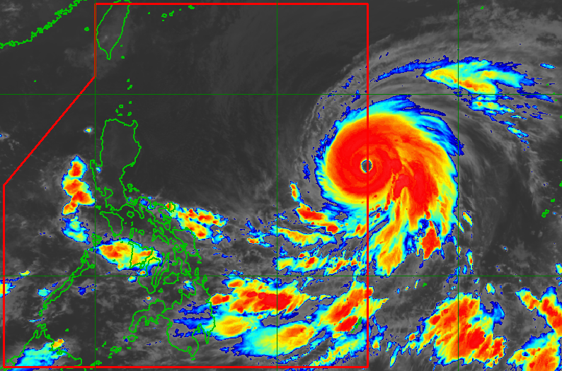
MANILA, Philippines – Super Typhoon Mawar entered the Philippine Area of Responsibility (PAR) at 2 am on Saturday, May 27, becoming the country’s second tropical cyclone for 2023 and the first super typhoon of the year.
Mawar, which has been given the local name Betty, entered PAR around two days after battering the United States island territory of Guam with torrential rain and fierce winds.
As of 4 am on Saturday, Betty was located 1,320 kilometers east of Central Luzon, moving west northwest at 25 kilometers per hour (km/h).
The super typhoon is expected to maintain its west northwest direction over the weekend, before turning northwest and slowing down on Monday, May 29, while over the waters east of extreme Northern Luzon.
It may eventually become almost stationary between late Tuesday, May 30, and early Wednesday, May 31, when it will be closest to Batanes or within 250 to 300 kilometers, said the Philippine Atmospheric, Geophysical, and Astronomical Services Administration (PAGASA) in its 5 am bulletin on Saturday.
Betty slightly weakened again as it entered PAR, with its maximum sustained winds at 195 km/h from the previous 205 km/h. Its gustiness went down to 240 km/h from 250 km/h.
PAGASA sees Betty remaining a super typhoon during the weekend.
“Although it will likely maintain its strength for the next 36 to 48 hours, short-term intensification is not ruled out especially in the next 12 to 24 hours,” said the weather bureau.
On Monday or Tuesday, however, Betty “may begin weakening considerably” as it lingers over the waters east of Batanes. It is projected to be downgraded to a typhoon then.
Betty’s forecast track as of 5 am on Saturday also shows a positive development – it has shifted a bit upward compared to previous tracks where the cone of uncertainty or probability still included mainland Cagayan. Landfall is less likely, though Betty remains a threat due to its size.

Given Betty’s latest forecast track and intensity, PAGASA provided the following rainfall forecast:
Early Monday morning, May 29, to early Tuesday morning, May 30
- 50-100 millimeters (mm): Batanes, Babuyan Islands, and northern parts of mainland Cagayan, Ilocos Norte, and Apayao
Early Tuesday morning, May 30, to early Wednesday morning, May 31
- Greater than 200 mm: Batanes
- 100-200 mm: Babuyan Islands, Ilocos Norte, Ilocos Sur, La Union
- 50-100 mm: Cordillera Administrative Region, northern part of mainland Cagayan
“Forecast rainfall are generally higher in elevated or mountainous areas,” the weather bureau said.
Betty is also expected to enhance the southwest monsoon or habagat.
PAGASA said monsoon rain is possible in the western parts of Mimaropa, the Visayas, and Mindanao on Sunday, May 28.
On Monday and Tuesday, monsoon rain is likely in the western parts of Mimaropa and Western Visayas, and possible in the remaining areas of these two regions.
The weather bureau warned that floods and landslides are likely.
Tropical cyclone wind signals could also be raised for some areas of Northern Luzon on Saturday evening or Sunday morning, so they can prepare in advance for winds triggered by Betty.
PAGASA added that the enhanced southwest monsoon may also cause “strong breeze to near-gale conditions with intermittent gusts” starting late Sunday or early Monday in the Visayas, the eastern parts of Central Luzon and Southern Luzon, and the northern and eastern parts of Mindanao.
As for coastal waters, here is the forecast for the next 24 hours:
- eastern seaboards of Luzon and Visayas – moderate to rough seas (waves 1.5 to 3.5 meters high) on Saturday morning, which may become rough to very rough (waves 2.5 to 5 meters high) on Saturday afternoon or evening
- northern seaboard of Luzon – moderate to rough seas (waves 1.5 to 3 meters high) from Saturday morning to afternoon and rough seas (waves 2.5 to 4 meters high) beginning Saturday evening
PAGASA advised small vessels to take precautionary measures or avoid sailing, if possible. – Rappler.com
Add a comment
How does this make you feel?


There are no comments yet. Add your comment to start the conversation.