SUMMARY
This is AI generated summarization, which may have errors. For context, always refer to the full article.

Super Typhoon Rolly (Goni) made its 2nd landfall in Tiwi, Albay, at 7:20 am on Sunday, November 1, bringing violent winds and torrential rain.
Its first landfall was in Bato, Catanduanes, at 4:50 am on Sunday.
The Philippine Atmospheric, Geophysical, and Astronomical Services Administration (PAGASA) said in a bulletin released past 8 am that Rolly is moving west at the same speed of 25 km/h, after hitting the municipality of Tiwi.
The super typhoon maintained its maximum sustained winds of 225 km/h, but its gustiness increased from 280 km/h to 310 km/h. It is the world’s strongest tropical cyclone for 2020, so far. (READ: FAST FACTS: Tropical cyclones, rainfall advisories)
PAGASA said “catastrophic violent winds and intense to torrential rainfall” from Rolly’s eyewall and inner rainbands are “prevailing or expected within the next 12 hours” in these areas:
- Catanduanes
- Camarines Norte
- Camarines Sur
- Albay
- northern part of Sorsogon
- Burias Island
- Marinduque
- central and southern parts of Quezon
- Laguna
- eastern part of Batangas
“This is a particularly dangerous situation for these areas,” the state weather bureau warned.
Below is the latest list of areas under tropical cyclone wind signals as of 8 am on Sunday. Metro Manila is among the areas upgraded to Signal No. 4.
Signal No. 5 (very destructive to devastating typhoon-force winds)
- Albay
- Camarines Sur
Signal No. 4 (very destructive to devastating typhoon-force winds)
- Catanduanes
- Camarines Norte
- northern part of Sorsogon (Donsol, Pilar, Castilla, Sorsogon City, Prieto Diaz, Gubat, Barcelona, Juban, Casiguran, Magallanes)
- Burias Island
- central and southern parts of Quezon (Real, Mauban, Perez, Alabat, Quezon, Calauag, Tagkawayan, Guinayangan, San Antonio, Tiaong, Dolores, Candelaria, Sariaya, Tayabas City, Sampaloc, Lucban, Lucena City, Pagbilao, Atimonan, Padre Burgos, Agdangan, Unisan, Plaridel, Gumaca, Lopez, Buenavista, San Narciso, San Andres, San Francisco, Mulanay, Catanauan, General Luna, Macalelon, Pitogo)
- central and southern parts of Rizal (Tanay, Antipolo City, San Mateo, Cainta, Taytay, Binangonan, Teresa, Morong, Cardona, Baras, Jala-Jala, Pililla, Angono)
- Batangas
- Cavite
- Metro Manila
- Laguna
- Marinduque
- northern part of Romblon (Concepcion, Corcuera, Banton)
- northern part of Occidental Mindoro (Abra de Ilog)
- northern part of Oriental Mindoro (Puerto Galera, San Teodoro, Baco, Calapan City, Naujan, Pola, Victoria, Socorro, Pinamalayan)
Signal No. 3 (destructive typhoon-force winds)
- rest of Sorsogon
- northern part of Masbate (Mobo, Masbate City, Milagros, Uson, Baleno, Aroroy, Mandaon) including Ticao Island
- rest of Quezon including Polillo Island
- rest of Rizal
- Bulacan
- Pampanga
- Bataan
- southern part of Zambales (San Marcelino, San Felipe, Olongapo City, Subic, Castillejos, San Antonio, San Narciso, Botolan, Cabangan)
- central part of Romblon (Calatrava, San Andres, San Agustin, Romblon, Magdiwang, San Fernando, Cajidiocan)
- central part of Occidental Mindoro (Sablayan, Mamburao, Santa Cruz, Paluan) including Lubang Island
- central part of Oriental Mindoro (Gloria, Bansud, Bongabong)
- Northern Samar
Signal No. 2 (damaging gale- to storm-force winds)
- Aurora
- Nueva Vizcaya
- Quirino
- Benguet
- La Union
- Pangasinan
- rest of Zambales
- Tarlac
- Nueva Ecija
- rest of Oriental Mindoro
- rest of Occidental Mindoro
- rest of Romblon
- rest of Masbate
- northern part of Samar (Catbalogan City, Jiabong, Motiong, Paranas, Hinabangan, San Sebastian, Tarangnan, Pagsanghan, San Jorge, San Jose de Buan, Matuguinao, Gandara, Santa Margarita, Calbayog City, Santo Niño, Almagro, Tagapul-an)
- northern part of Eastern Samar (San Julian, Sulat, Taft, Can-avid, Dolores, Maslog, Oras, San Policarpo, Arteche, Jipapad)
- extreme northern part of Antique (Pandan, Libertad, Caluya)
- northwestern part of Aklan (Buruanga, Malay, Nabas, Ibajay)
Signal No. 1 (strong breeze to near gale conditions)
- mainland Cagayan
- Isabela
- Apayao
- Kalinga
- Mountain Province
- Ifugao
- Abra
- Ilocos Norte
- Ilocos Sur
- Calamian Islands
- rest of northern part of Antique (Sebaste, Culasi, Tibiao, Barbaza, Laua-an)
- rest of Aklan
- Capiz
- northern part of Iloilo (Lemery, Sara, Concepcion, San Dionisio, Batad, Estancia, Balasan, Carles)
- northern part of Cebu (San Remigio, Bogo City, Medellin, Daanbantayan) including Bantayan Islands
- Biliran
- rest of Samar
- rest of Eastern Samar
- northern part of Leyte (San Isidro, Tabango, Villaba, Matag-ob, Palompon, Ormoc City, Pastrana, Palo, Calubian, Leyte, Kananga, Capoocan, Carigara, Jaro, Tunga, Barugo, Alangalang, Santa Fe, Tacloban City, Babatngon, San Miguel)
PAGASA added that strong breeze to near gale conditions due to the northeasterlies will be experienced over the rest of Northern Luzon that are not under Signal No. 1.
The state weather bureau maintained its rainfall outlook for Rolly, again reminding the public to watch out for floods and landslides.
Heavy to intense rain, with at times torrential rain
- Bicol
- Calabarzon
- Metro Manila
- Marinduque
- Romblon
- Oriental Mindoro
- Occidental Mindoro
- Bataan
- Bulacan
- Aurora
- eastern parts of mainland Cagayan and of Isabela
- Northern Samar
- Samar
- Eastern Samar
- Biliran
Moderate to heavy rain, with at times intense rain
- Cordillera Administrative Region
- rest of Central Luzon
- rest of mainland Cagayan Valley
- Leyte
Light to moderate rain, with at times heavy rain
- rest of Luzon
- rest of Visayas
- Caraga
- Northern Mindanao
- Zamboanga Peninsula
In addition, there is a high risk of storm surges in the next 24 hours. These storm surges, “which may be accompanied by swells and breaking waves reaching the coast, can cause life-threatening and damaging coastal inundation.”
More than 3 meters high
- coastal areas of Catanduanes and Camarines Norte
- northern coastal areas of Quezon including Polillo Island and Camarines Sur
Up to 3 meters high
- coastal areas of Metro Manila, Cavite, Bulacan, Pampanga, Bataan
- southeastern coastal area of Batangas, facing Tayabas Bay
- most of the southern coastal areas of Quezon
Up to 2 meters high
- coastal areas of Marinduque, Lubang Island, Albay, Masbate including Ticao and Burias Islands, Northern Samar, Eastern Samar
- remaining coastal areas of Quezon, Camarines Sur, and Batangas
“Moreover, there is also a moderate to high risk of seiche or storm surge over the coastal areas surrounding Laguna de Bay and Taal Lake,” added PAGASA.
Travel is also risky for all types of vessels in:
- seaboards of areas under tropical cyclone wind signals – rough to phenomenal seas, with waves 2.5 to 16 meters high
- remaining seaboards of Northern Luzon as well as eastern seaboards of Eastern Visayas that are not under a tropical cyclone wind signal and Caraga – rough to very rough seas, with waves 2.5 to 5 meters high
In the remaining seaboards of the country, there are moderate to rough seas, with waves 1.2 to 2.5 meters high. PAGASA advised those using small vessels to take precautionary measures, while “inexperienced mariners should avoid navigating in these conditions.”
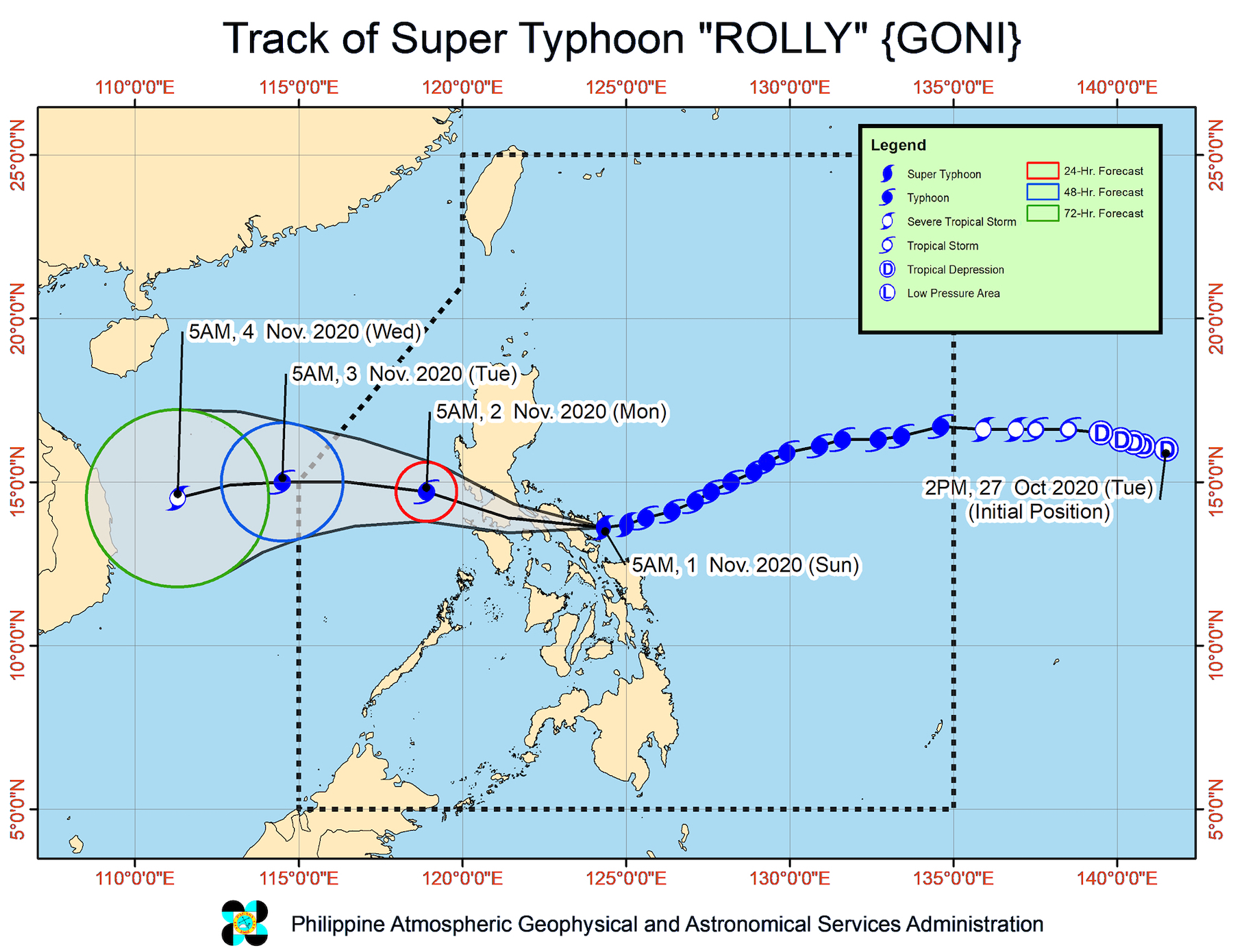
Rolly’s track
After hitting Albay, the center of the super typhoon will cross Camarines Sur and Camarines Norte on Sunday morning, according to PAGASA.
Then it will head toward the Marinduque-southern Quezon area on Sunday afternoon.
Rolly is forecast to exit mainland Luzon landmass and emerge over the West Philippine Sea between Sunday night and early Monday morning, November 2.
By the time it emerges over sea, it would have weakened back into a typhoon.
Rolly could leave the Philippine Area of Responsibility (PAR) in the early hours of Tuesday, November 3.
Meanwhile, Tropical Storm Atsani, located outside PAR, is now 1,205 kilometers east of Southern Luzon.
It is still moving west northwest at a relatively fast 30 km/h and is already expected to enter PAR on Sunday morning, joining Rolly.
Once Atsani enters, it will be given the local name Siony. (READ: LIST: PAGASA’s names for tropical cyclones in 2020)
Atsani continues to have maximum sustained winds of 65 km/h and gustiness of up to 80 km/h. It is likely to intensify into a severe tropical storm in the next 24 to 36 hours.
But PAGASA maintained that Atsani or the potential Siony “remains less likely to affect any portion of the country over the next 2 to 3 days.”
Rolly is the Philippines’ 18th tropical cyclone for 2020, while Siony would be the 19th. Rolly is also the 5th tropical cyclone for October alone.
An average of 20 tropical cyclones form within or enter PAR each year.
These are PAGASA’s latest estimates for the number of tropical cyclones inside PAR in the next 6 months:
- November 2020 – 1 to 3
- December 2020 – 2 or 3
- January 2021 – 0 or 1
- February 2021 – 0 or 1
- March 2021 – 0 or 1
- April 2021 – 0 or 1
Last October 2, the state weather bureau warned Filipinos to expect more rain in the coming months due to the onset of La Niña. – Rappler.com
Add a comment
How does this make you feel?


There are no comments yet. Add your comment to start the conversation.