SUMMARY
This is AI generated summarization, which may have errors. For context, always refer to the full article.
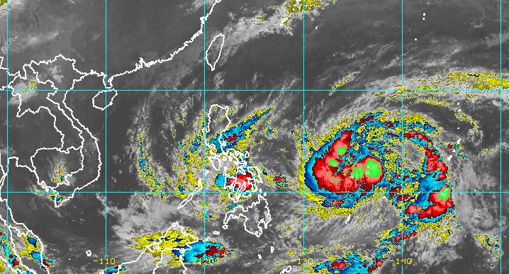
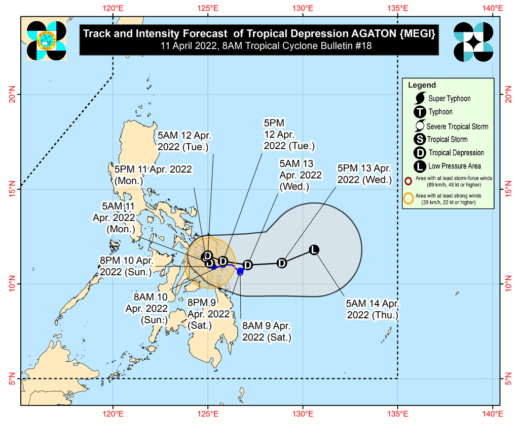
MANILA, Philippines – Agaton (Megi) weakened from a tropical storm into a tropical depression early Monday morning, April 11, while over San Pablo Bay, particularly over the coastal waters of Tanauan, Leyte.
Agaton’s maximum sustained winds decreased from 65 kilometers per hour to 55 km/h, while its gustiness is now up to 75 km/h from the previous 90 km/h.
The tropical depression is still moving slowly, heading north northwest, the Philippine Atmospheric, Geophysical, and Astronomical Services Administration (PAGASA) said in its bulletin released past 8 am on Monday.
Since Agaton has been downgraded to a tropical depression, there are no more areas under Signal No. 2 as of 8 am on Monday. But the following areas remain under Signal No. 1, which means they are experiencing strong winds that pose a “minimal to minor threat to life and property”:
- southern part of Masbate (Dimasalang, Palanas, Cataingan, Pio V. Corpuz, Esperanza, Placer, Cawayan)
- Eastern Samar
- Samar
- Northern Samar
- Biliran
- Leyte
- Southern Leyte
- northeastern part of Cebu (Daanbantayan, San Remigio, Medellin, Bogo City, Tabogon, Borbon, Sogod, Catmon, Carmen, Danao City, Compostela, Liloan) including Camotes Island
- eastern part of Bohol (Getafe, Talibon, Bien Unido, Trinidad, Ubay, San Miguel, President Carlos P. Garcia, Mabini)
- Surigao del Norte
- Dinagat Islands
The slow-paced Agaton will continue to trigger rain as well.
Monday, April 11
Moderate to heavy rain, with at times intense rain
- Eastern Visayas
- northern and central parts of Cebu including Bantayan and Camotes Islands
- Masbate
- Sorsogon
- Catanduanes
Light to moderate rain, with at times heavy rain
- Dinagat Islands
- rest of Visayas
- rest of Bicol
- Oriental Mindoro
- Marinduque
- Romblon
- Quezon
Tuesday, April 12
Moderate to heavy rain, with at times intense rain
- Sorsogon
- Masbate
- Eastern Visayas
Light to moderate rain, with at times heavy rain
- Dinagat Islands
- rest of Visayas
- Romblon

Agaton has lingered off Eastern Visayas since the past weekend. It made landfall in Calicoan Island in Guiuan, Eastern Samar, at 7:30 am on Sunday, April 10.
From Monday to Tuesday afternoon, April 12, Agaton is expected to make a loop while in the vicinity of the northeastern part of Leyte and the southern parts of Samar and Eastern Samar, essentially starting to move away from land.
Agaton would then emerge over the Philippine Sea by Tuesday evening as it begins to interact with the incoming Severe Tropical Storm Malakas. This interaction may result in Agaton further weakening into a remnant low by Wednesday evening, April 13, as it gets absorbed by Malakas.
PAGASA earlier said Malakas may enter the Philippine Area of Responsibility (PAR) on Monday evening or Tuesday morning. It would be given the local name Basyang.
While Malakas or Basyang is likely to influence Agaton’s movement, it is not seen to make landfall and will have no direct effect on weather in the Philippines. It is expected to leave PAR late Tuesday or early Wednesday.
Sea travel remains risky on Monday.
Rough to very rough seas
Waves 2.8 to 4.5 meters high; conditions risky for most vessels
- seaboards of areas under Signal No. 1
Moderate to rough seas
Waves 1.2 to 3.4 meters high; conditions risky for small vessels
- remaining seaboards of the Philippines
– Rappler.com
Add a comment
How does this make you feel?


There are no comments yet. Add your comment to start the conversation.