SUMMARY
This is AI generated summarization, which may have errors. For context, always refer to the full article.
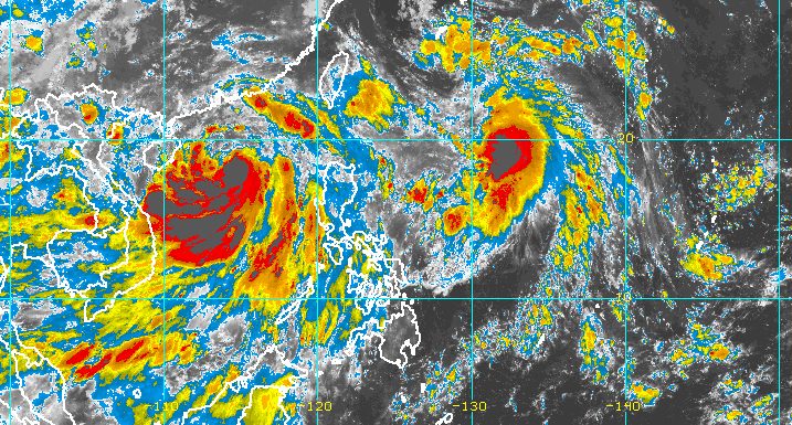
MANILA, Philippines – Tropical Depression Domeng maintained its strength in the early hours of Friday, July 1, while Caloy (Chaba) outside the Philippine Area of Responsibility (PAR) intensified from a tropical storm into a severe tropical storm.
Caloy and Domeng will still enhance the southwest monsoon or hanging habagat on Friday, said the Philippine Atmospheric, Geophysical, and Astronomical Services Administration (PAGASA).
Domeng was last spotted 950 kilometers east of Basco, Batanes, moving north at 20 kilometers per hour (km/h).
The tropical depression continues to have maximum sustained winds of 55 km/h and gustiness of up to 70 km/h. But it is likely to strengthen into a tropical storm within 12 hours, according to PAGASA.
There are no tropical cyclone wind signals in effect since Domeng is too far from the country.
Meanwhile, Caloy was located 625 kilometers west of Iba, Zambales, moving west northwest outside PAR at 15 km/h. Its maximum sustained winds increased to 95 km/h from the previous 85 km/h, and its gustiness is now up to 115 km/h from 105 km/h.
The southwest monsoon enhanced by Caloy and Domeng will affect these areas on Friday:
Monsoon rain
- Zambales
- Bataan
- Occidental Mindoro
- Palawan
Scattered rain and thunderstorms
- rest of Central Luzon
- rest of Mimaropa
- Metro Manila
- Ilocos Region
- Cordillera Administrative Region
- Calabarzon
- Western Visayas
Still because of the southwest monsoon, occasionally gusty conditions are likely in the following areas:
- extreme Northern Luzon
- northern and western parts of Luzon
- western part of Visayas
PAGASA also issued a gale warning at 5 am on Friday for the western seaboard of Luzon, covering the following:
- Zambales
- Bataan
- western coast of Occidental Mindoro including Lubang Island
- western coast of Palawan including Kalayaan Island
- Ilocos Sur
- La Union
- Pangasinan
Those areas will have rough to very rough seas, with waves 2.8 to 4.5 meters high.
The remaining seaboards of Northern Luzon, meanwhile, will have moderate to rough seas. Waves are 2.1 to 4 meters high and risky for small vessels.
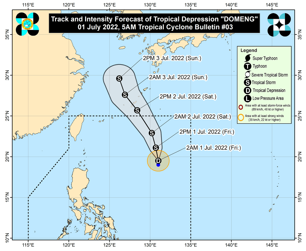
PAGASA sees Domeng gradually speeding up north northwest over the next three days and staying far from Philippine landmass.
Domeng may exit PAR on Saturday, July 2, either in the morning or afternoon. It may then pass very close to or make landfall in Japan’s Ryukyu Islands on Saturday afternoon or evening.
Domeng is the Philippines’ fourth tropical cyclone for 2022, while Caloy was the third.
PAGASA expects 11 to 15 tropical cyclones to enter or develop inside PAR from July to December. Per month, these are the weather bureau’s estimates:
- July – 2 or 3
- August – 2 or 3
- September – 2 or 3
- October – 2 to 4
- November – 2 or 3
- December – 1 or 2
– Rappler.com
Add a comment
How does this make you feel?


There are no comments yet. Add your comment to start the conversation.