SUMMARY
This is AI generated summarization, which may have errors. For context, always refer to the full article.
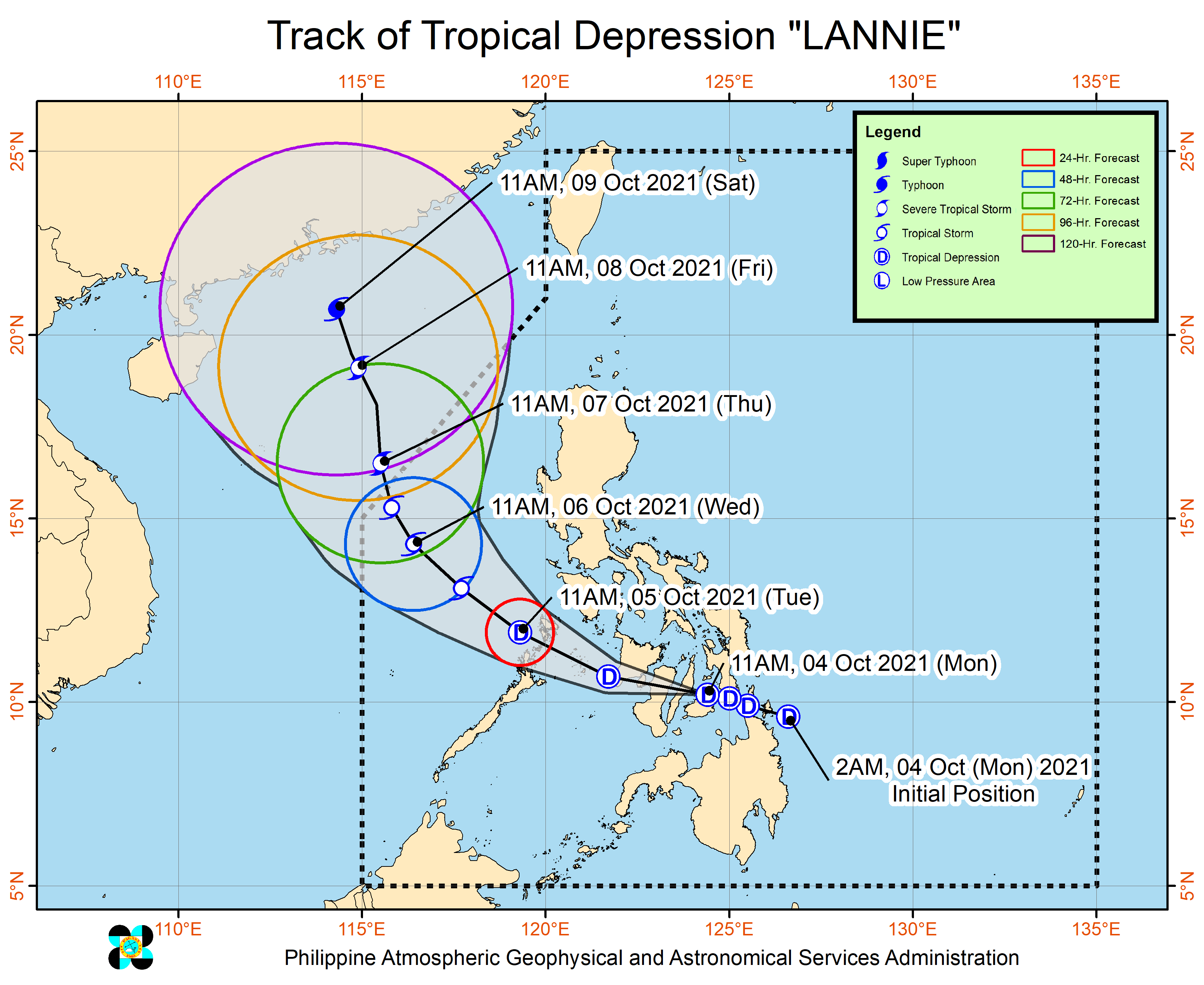
Tropical Depression Lannie continued to cross the Visayas, making its fifth and sixth landfalls early Monday afternoon, October 4, in two islands which are part of the province of Bohol.
Lannie’s landfalls, so far, have been in these areas:
- Bucas Grande Island, Socorro, Surigao del Norte – 4:30 am
- Cagdianao, Dinagat Islands – 5 am
- Liloan, Southern Leyte – 7:30 am
- Padre Burgos, Southern Leyte – 8 am
- Mahanay Island, Talibon, Bohol – 12:30 pm
- Banacon Island, Jetafe, Bohol – 12:45 pm
Following its sixth landfall, Lannie moved over the coastal waters of the municipality of Jetafe, starting to head for the central part of Cebu province.
The tropical depression was moving west, maintaining its speed of 20 kilometers per hour (km/h).
Lannie’s intensity also remains unchanged, with maximum sustained winds of 45 km/h and gustiness of up to 55 km/h. (READ: FAST FACTS: Tropical cyclones, rainfall advisories)
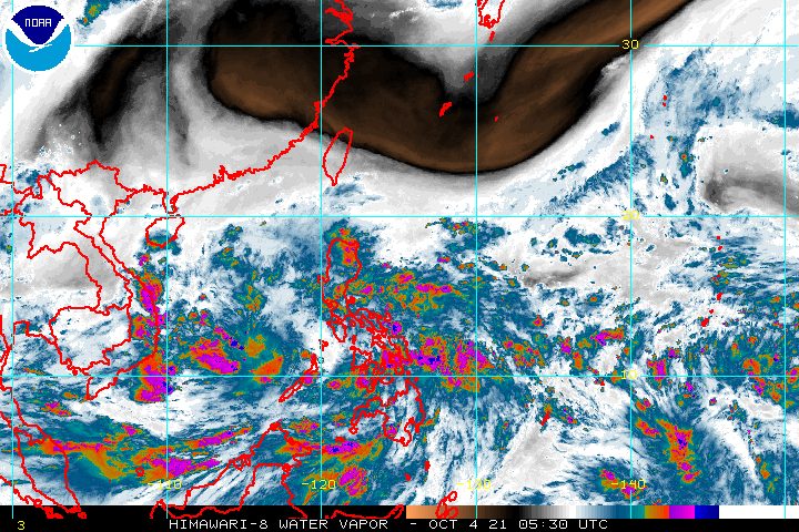
The Philippine Atmospheric, Geophysical, and Astronomical Services Administration (PAGASA) reiterated in its 2 pm bulletin on Monday that rain from the tropical depression may persist until Tuesday morning, October 5. This could cause scattered floods and landslides.
Moderate to heavy rain, with at times intense rain
- Visayas
- Mimaropa
- Albay
- Sorsogon
- Masbate including Ticao and Burias Islands
- Dinagat Islands
Light to moderate rain, with at times heavy rain
- Calabarzon
- rest of Bicol
- rest of Mindanao
Parts of Luzon, the Visayas, and Mindanao are still under Signal No. 1, experiencing strong winds with occasional gusts. A few areas in Mindanao have been removed from the list as of 2 pm on Monday.
- southern part of Masbate (Pio V. Corpuz, Cataingan, Palanas, Dimasalang, Uson, Mobo, Milagros, Mandaon, Esperanza, Placer, Cawayan, Balud)
- southern part of Romblon (Cajidiocan, San Fernando, Magdiwang, Santa Maria, Odiongan, Alcantara, Ferrol, Looc, Santa Fe, San Jose)
- southern part of Oriental Mindoro (Roxas, Mansalay, Bulalacao, Bongabong)
- southern part of Occidental Mindoro (Sablayan, Calintaan, Rizal, San Jose, Magsaysay)
- northern part of Palawan (El Nido, Taytay, Dumaran, Araceli), including Calamian and Cuyo Islands
- Eastern Samar
- Samar
- Biliran
- Leyte
- Southern Leyte
- Capiz
- Aklan
- Antique
- Iloilo
- Guimaras
- Negros Occidental
- northern and central parts of Negros Oriental (Bais City, Mabinay, Bayawan City, Basay, Tanjay City, Manjuyod, Bindoy, Ayungon, Tayasan, Jimalalud, La Libertad, Guihulngan City, Vallehermoso, Canlaon City)
- Cebu
- Bohol
- northwestern part of Surigao del Norte (Sison, San Francisco, Surigao City, Tagana-an, Placer, Malimono, Mainit, Tubod)
- Dinagat Islands
PAGASA added that “the enhanced easterly flow north of the tropical depression may also bring occasional gusts” to extreme Northern Luzon and the coastal and mountainous areas of the eastern part of Luzon on Monday.
Lannie is also causing moderate to rough seas in the Philippines’ coastal waters on Monday, especially in areas under Signal No. 1. Travel is risky for small vessels.
PAGASA said Lannie will maintain a west or west northwest direction as it moves over the Visayas until Monday evening, before emerging over the Sulu Sea and crossing the Cuyo archipelago.
Another landfall is possible in the northern part of Palawan or Calamian Islands on Tuesday morning. This would be Lannie’s final landfall before it exits landmass toward the West Philippine Sea.
From late Tuesday to early Thursday morning, October 7, Lannie will be moving over the West Philippine Sea.
Lannie is projected to stay a tropical depression while crossing land, though it may slightly intensify once over the Sulu Sea or the West Philippine Sea. It could strengthen into a tropical storm by Tuesday evening or early Wednesday morning, October 6.
Lannie may leave the Philippine Area of Responsibility (PAR) on Thursday morning, then head for the southern part of China.
PAGASA added that Lannie will continue intensifying outside PAR. It may be upgraded into a severe tropical storm by Thursday morning – earlier than previously expected – and into a typhoon by Saturday morning, October 9 – a new addition to the forecast.
Lannie is the Philippines’ 12th tropical cyclone for 2021. It is also the first tropical cyclone for the month of October, coming right in the middle of the filing of certificates of candidacy for the 2022 elections, which is taking place across the country. The filing of COCs is until Friday, October 8.
An average of 20 tropical cyclones form within or enter PAR each year. (READ: LIST: PAGASA’s names for tropical cyclones in 2021)
These are PAGASA’s latest estimates for the next six months:
2021
- October – 2 or 3
- November – 2 or 3
- December – 1 or 2
2022
- January – 0 or 1
- February – 0 or 1
- March – 0 or 1
The weather bureau is also monitoring the possible emergence of La Niña in the fourth quarter of 2021. – Rappler.com
Add a comment
How does this make you feel?


There are no comments yet. Add your comment to start the conversation.