SUMMARY
This is AI generated summarization, which may have errors. For context, always refer to the full article.
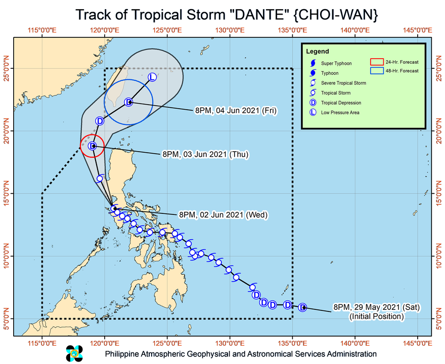
Tropical Storm Dante (Choi-wan) made its seventh and eighth landfalls in the province of Batangas on Wednesday evening, June 2, as it continued to bring heavy rain to parts of Luzon.
Here are the areas where Dante has made landfall, so far:
Tuesday, June 1
- Sulat, Eastern Samar – 8:30 pm
Wednesday, June 2
- Cataingan, Masbate – 1 am
- Balud, Masbate – 3:30 am
- Romblon, Romblon – 8 am
- San Agustin, Romblon – 8:50 am
- Pola, Oriental Mindoro – 2 pm
- Maricaban Island, Tingloy, Batangas – 7:20 pm
- Calatagan, Batangas – 8 pm
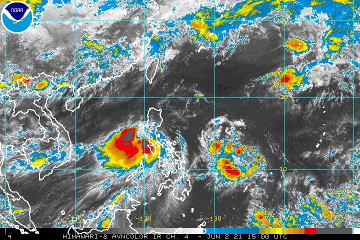
The tropical storm was last spotted over the coastal waters of Nasugbu, Batangas, said the Philippine Atmospheric, Geophysical, and Astronomical Services Administration (PAGASA) in its briefing past 11 pm on Wednesday.
It was moving northwest at 15 kilometers per hour (km/h), heading for the Bataan-Zambales area.
PAGASA said Dante was likely to make another landfall in Bataan or in the southern tip of Zambales within three to six hours, before emerging over the West Philippine Sea – off Pangasinan’s western coast – on Thursday morning, June 3.
Then Dante may pass over the Luzon Strait close to Taiwan’s southern coast on Friday, June 4, added the state weather bureau.
As of late Wednesday evening, Dante still had maximum sustained winds of 65 km/h and gustiness of up to 90 km/h.
PAGASA said the tropical storm could maintain its strength within the next 12 hours, or until Thursday morning, while passing through Luzon’s western coast.
But it also said Dante could weaken into a tropical depression during the same period “if it tracks more inland, where the terrain is more rugged, such as over the Zambales Mountain Range.”
Another scenario shows Dante becoming a tropical depression by Thursday evening and a remnant low by Saturday, June 5. (READ: FAST FACTS: Tropical cyclones, rainfall advisories)
In the meantime, rainfall warnings remain in effect for parts of Luzon, which means affected areas may face more floods and landslides. Here’s what to expect on Thursday:
Moderate to heavy rain, with at times intense rain
- northern part of Occidental Mindoro including Lubang Islands
- northern part of Oriental Mindoro
- Batangas
- Cavite
- Bataan
- Zambales
- Pangasinan
Light to moderate rain, with at times heavy rain
- Cordillera Administrative Region
- Metro Manila
- Calamian Islands
- Romblon
- Marinduque
- rest of Ilocos Region
- rest of Central Luzon
- rest of Calabarzon
- Occidental Mindoro
- Oriental Mindoro
In terms of winds, below are the areas where tropical cyclone wind signals are raised as of 11 pm on Wednesday.
Signal No. 2
Damaging gale-force winds prevailing or expected within 24 hours
- extreme northern part of Oriental Mindoro (Puerto Galera)
- extreme northern part of Occidental Mindoro (Paluan, Lubang Islands, Abra de Ilog)
- Batangas
- Cavite
- Bataan
- southwestern part of Bulacan (Calumpit, Bulacan, Malolos City, Paombong, Hagonoy)
- western part of Pampanga (Masantol, Macabebe, Sasmuan, Lubao, Floridablanca, Porac, Guagua, Santa Rita, Angeles City, Mabalacat City, Minalin, Bacolor)
- Zambales
- western part of Tarlac (Bamban, Capas, San Jose, Mayantoc, Camiling, Santa Ignacia, San Clemente)
- western part of Pangasinan (Bolinao, Anda, Bani, Agno, Burgos, Infanta, Dasol, Alaminos City, Mabini, Sual, Labrador, Bugallon, Aguilar, Mangatarem, Bayambang, Urbiztondo, Basista, Malasiqui, San Carlos City, Santa Barbara, Mangaldan, Dagupan City, Calasiao, Binmaley, Lingayen)
Signal No. 1
Strong winds prevailing or expected within 36 hours
- rest of northern part of Oriental Mindoro (Bansud, Gloria, Pola, Pinamalayan, Socorro, Victoria, Naujan, Baco, Calapan City, San Teodoro
- rest of the northern part of Occidental Mindoro (Sablayan, Calintaan, Mamburao, Santa Cruz)
- western part of Quezon (San Antonio, Tiaong, Candelaria, Sariaya, Dolores, Lucban, Tayabas City, Lucena City, Sampaloc)
- Laguna
- Metro Manila
- Rizal
- rest of Bulacan
- rest of Pampanga
- rest of Tarlac
- western part of Nueva Ecija (Science City of Muñoz, Lupao, Cuyapo, Talugtug, Guimba, Nampicuan, Quezon, Licab, Santo Domingo, Talavera, Cabanatuan City, Santa Rosa, Aliaga, Zaragoza, Jaen, San Antonio, Cabiao, San Isidro, San Leonardo, Gapan City, Peñaranda)
- rest of Pangasinan
- southern part of Benguet (Itogon, Tuba, Sablan, Baguio City, La Trinidad, Kapangan, Tublay)
- La Union
PAGASA said winds in areas under Signal No. 2 could bring “generally light to moderate damage to structures and vegetation,” while winds in areas under Signal No. 1 may cause “generally very light damage.”
On Thursday, it would still be dangerous to travel in some of the country’s seaboards.
Rough to very rough seas (waves 2.5 to 4 meters high)
Travel is risky for small vessels, while “mariners without the proper experience should immediately seek safe harbor”
- seaboards of areas under Signal No. 2
Moderate to rough seas (waves 1.2 to 3 meters high)
Small vessels must take precautionary measures, while inexperienced mariners should avoid venturing out to sea
- seaboards of areas under Signal No. 1
- remaining seaboards of Northern Luzon
- eastern seaboard of Central Luzon
- seaboard of Quezon including Polillo Islands
- remaining seaboards of Occidental Mindoro and Oriental Mindoro
- seaboard of Marinduque
- western seaboard of Romblon
PAGASA is also monitoring a low pressure area (LPA) poised to enter the Philippine Area of Responsibility (PAR).
As of Wednesday evening, the LPA was located 1,185 kilometers east of Southern Luzon. Updates are expected in the coming days.
Dante is the Philippines’ fourth tropical cyclone for 2021. The country has an average of 20 tropical cyclones every year. (READ: LIST: PAGASA’s names for tropical cyclones in 2021)
For June to November, PAGASA estimates the following number of tropical cyclones inside PAR:
- June – 1 to 3
- July – 2 to 4
- August – 2 or 3
- September – 2 or 3
- October – 2 or 3
- November – 2 or 3
PAGASA said on Wednesday that the criteria for the declaration of the rainy season could soon be met in the coming days, given the rain from Dante. – Rappler.com
Add a comment
How does this make you feel?


There are no comments yet. Add your comment to start the conversation.