SUMMARY
This is AI generated summarization, which may have errors. For context, always refer to the full article.
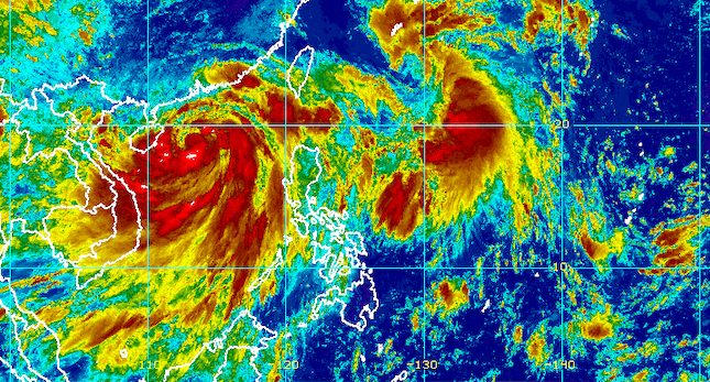
MANILA, Philippines – Domeng strengthened from a tropical depression into a tropical storm at 8 am on Friday, July 1, while over the Philippine Sea and far from the country’s landmass.
It was given the international name Aere.
In a briefing past 11 am on Friday, the Philippine Atmospheric, Geophysical, and Astronomical Services Administration (PAGASA) said Domeng now has maximum sustained winds of 65 kilometers per hour from the previous 55 km/h and gustiness of up to 80 km/h from 70 km/h.
There are no tropical cyclone wind signals in effect since Domeng is too far from the country.
The tropical storm was last spotted 940 kilometers east of extreme Northern Luzon, moving north at 15 km/h. At this pace, it may exit the Philippine Area of Responsibility (PAR) on Saturday, July 2, either morning or afternoon.
Meanwhile, Severe Tropical Storm Caloy (Chaba), which left PAR last Wednesday, June 29, was located 715 kilometers west of Sinait, Ilocos Sur, on Friday morning.
Both Caloy and Domeng are still enhancing the southwest monsoon or hanging habagat. Here is PAGASA’s updated rainfall forecast for the enhanced southwest monsoon as of 11 am on Friday:
Moderate to heavy rain
- Kalayaan Islands
Light to moderate rain, with at times heavy rain
- rest of Palawan
- Pangasinan
- Zambales
- Bataan
- Occidental Mindoro
Scattered floods and landslides remain possible in the affected provinces.
Occasionally gusty conditions are still expected in the following areas:
- extreme Northern Luzon
- northern and western parts of Luzon
- western part of Visayas
A gale warning also remains in place for the western seaboard of Luzon, covering the following:
- Zambales
- Bataan
- western coast of Occidental Mindoro including Lubang Island
- western coast of Palawan including Kalayaan Island
- Ilocos Sur
- La Union
- Pangasinan
Those areas will have rough to very rough seas, with waves 2.8 to 4.5 meters high.
The remaining seaboards of Northern Luzon, meanwhile, will have moderate to rough seas. Waves are 2.1 to 4 meters high and risky for small vessels.

After Domeng leaves PAR, it could pass very close to or make landfall in Japan’s Ryukyu Islands on Saturday afternoon or evening. During that time as well, it may strengthen into a severe tropical storm with a peak intensity of 95 km/h, according to PAGASA.
Domeng is the Philippines’ fourth tropical cyclone for 2022, while Caloy was the third.
PAGASA expects 11 to 15 tropical cyclones to enter or develop inside PAR from July to December. Per month, these are the weather bureau’s estimates:
- July – 2 or 3
- August – 2 or 3
- September – 2 or 3
- October – 2 to 4
- November – 2 or 3
- December – 1 or 2
– Rappler.com
Add a comment
How does this make you feel?


There are no comments yet. Add your comment to start the conversation.