SUMMARY
This is AI generated summarization, which may have errors. For context, always refer to the full article.
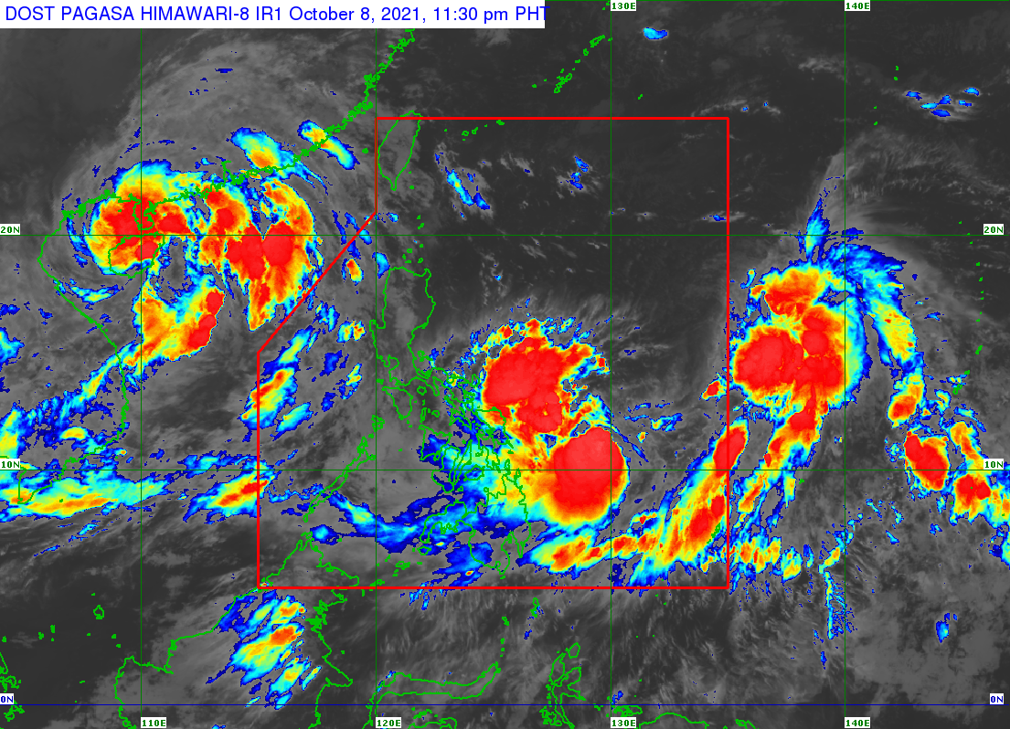
There were already two tropical cyclones inside the Philippine Area of Responsibility (PAR) on Friday evening, October 8.
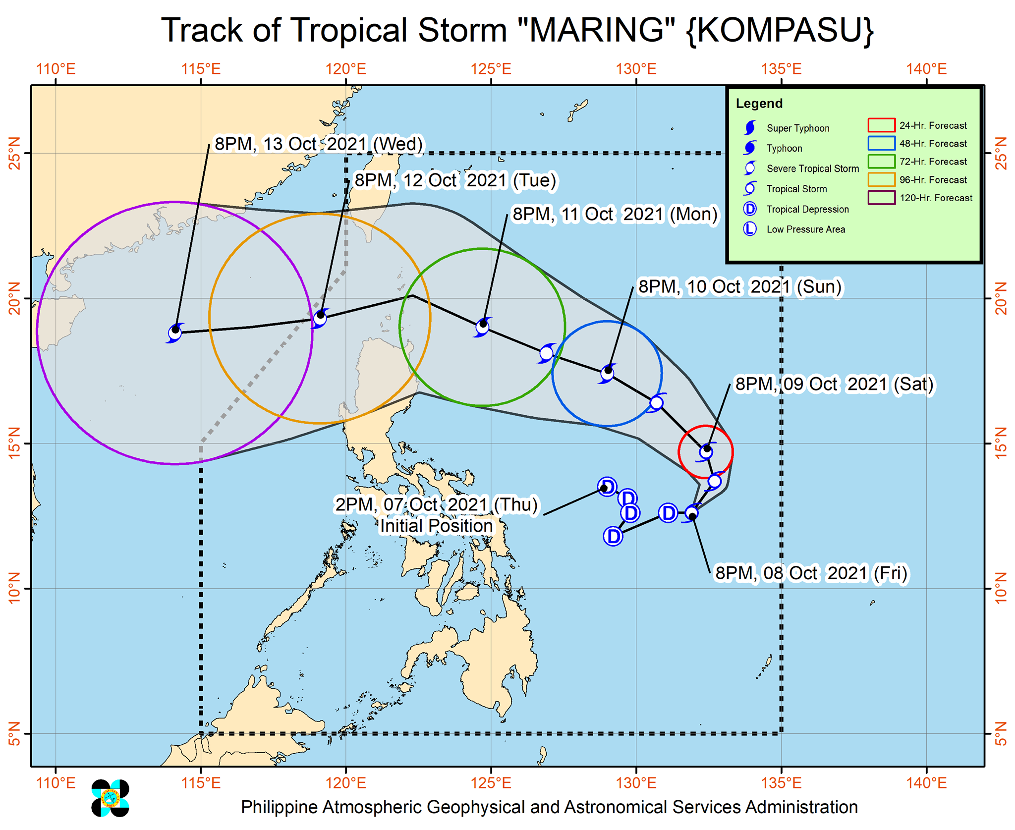
The first one, Maring, intensified from a tropical depression into a tropical storm over the Philippine Sea on Friday evening. It was given the international name Kompasu.
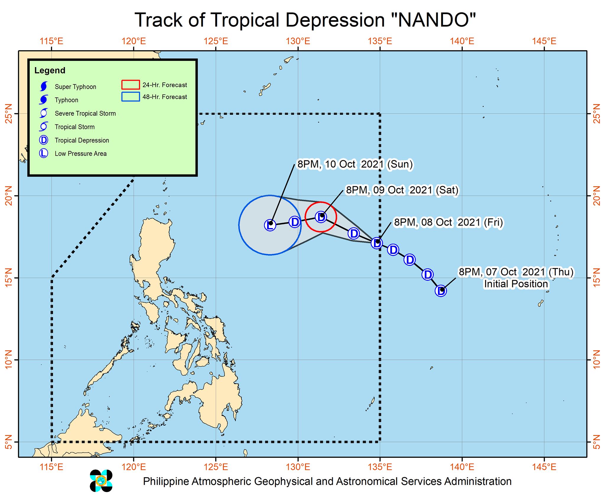
At 8 pm, another tropical depression entered PAR, getting the local name Nando.
Maring
Maring was last spotted 715 kilometers east of Borongan City, Eastern Samar, or 790 kilometers east of Catarman, Northern Samar, said the Philippine Atmospheric, Geophysical, and Astronomical Services Administration (PAGASA) in a bulletin released past midnight on Saturday, October 9.
The tropical storm is moving east northeast at 15 kilometers per hour (km/h).
Its maximum winds have increased to 65 km/h, with gustiness of up to 80 km/h.
PAGASA sees Maring possibly becoming a severe tropical storm by Sunday evening, October 10. (READ: FAST FACTS: Tropical cyclones, rainfall advisories)
Below is the weather bureau’s rainfall forecast for Maring, covering Saturday.
Moderate to heavy rain
- Eastern Visayas
- Caraga
Light to moderate rain, with at times heavy rain
- Bicol
- Cebu
- Bohol
The weather bureau added that the southwesterly wind flow, which is being enhanced by Maring, may start bringing light to heavy rain to the rest of the Visayas, Palawan, and Occidental Mindoro on Saturday afternoon or evening.
Both Maring and the enhanced southwesterly wind flow could trigger scattered floods and landslides.
There are still no tropical cyclone wind signals in effect. But PAGASA explained that Maring is a “large” tropical storm with an “expansive wind field,” so occasional gusts are still possible in the following areas:
- Eastern Visayas
- Caraga
- Catanduanes
- Albay
- Sorsogon
Signal No. 1 could be raised for parts of Northern Luzon beginning Saturday or Sunday.
The highest possible tropical cyclone wind signal due to Maring remains Signal No. 2.
But PAGASA is not ruling out the possibility of raising tropical cyclone wind signals even in areas outside Northern Luzon, and the possibility of declaring higher wind signals, if there are changes in Maring’s intensity and track – including a potential merger with Nando.
Maring may cross the Luzon Strait and pass over or close to Batanes and the Babuyan Islands on Monday, October 11, or Tuesday, October 12.
Nando
Meanwhile, Nando was located 1,305 kilometers east of Northern Luzon on Friday evening, moving west northwest at 20 km/h.
The tropical depression has maximum sustained winds of 55 km/h and gustiness of up to 70 km/h.
It is not likely to strengthen, and may even weaken into a low pressure area on Sunday.
Nando is not expected to directly affect weather in the Philippines.
Potential merger
PAGASA explained that both Maring and Nando are “embedded within the larger circulation of a monsoon depression.”
Maring is expected to move northeast, then northwest in the next 36 hours or during the weekend as it interacts with Nando. Their interaction could result in a merger on Sunday.
“Nando may likely be assimilated and merged into the circulation of Maring,” PAGASA said.
But the weather bureau noted that given “the trend of changes” observed, so far, and the “uncertainty” of the Maring-Nando merger, forecasts can still change.
Maring is the Philippines’ 13th tropical cyclone for 2021 and the second for October, while Nando is the country’s 14th for the year and the third for the month.
An average of 20 tropical cyclones form within or enter PAR each year. (READ: LIST: PAGASA’s names for tropical cyclones in 2021)
These are PAGASA’s latest estimates for the next six months:
2021
- October – 2 or 3
- November – 2 or 3
- December – 1 or 2
2022
- January – 0 or 1
- February – 0 or 1
- March – 0 or 1
The weather bureau is also monitoring the possible emergence of La Niña in the fourth quarter of 2021. – Rappler.com
Add a comment
How does this make you feel?


There are no comments yet. Add your comment to start the conversation.