SUMMARY
This is AI generated summarization, which may have errors. For context, always refer to the full article.
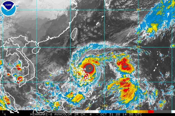
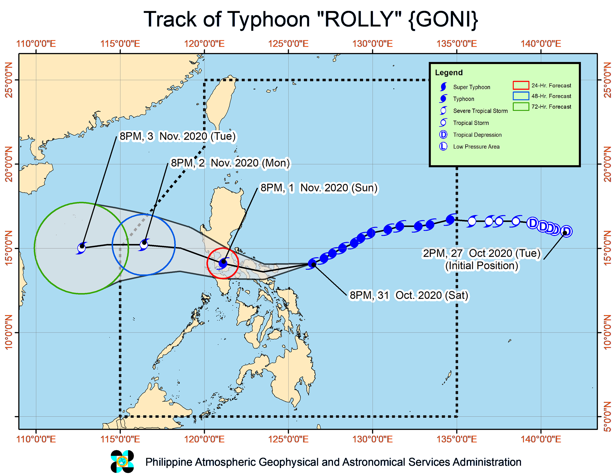
The region of Bicol was “under serious threat” late Saturday evening, October 31, as Typhoon Rolly (Goni) continued to move closer to the province of Catanduanes.
The Philippine Atmospheric, Geophysical, and Astronomical Services Administration (PAGASA) said Rolly is located 185 kilometers east of Virac, Catanduanes, moving west southwest at a slightly faster 25 kilometers per hour (km/h) from the previous 20 km/h.
Rolly continues to have maximum sustained winds of 215 km/h and gustiness of up to 265 km/h. Though not a super typhoon under PAGASA’s classification system – a super typhoon has winds exceeding 220 km/h – Rolly is the world’s strongest tropical cyclone for 2020 so far. (READ: FAST FACTS: Tropical cyclones, rainfall advisories)

PAGASA warned that the center of the eye of Typhoon Rolly may make landfall “at or near its current peak intensity” in Catanduanes early Sunday morning, November 1, and then in Camarines Sur also on Sunday morning.
“Violent winds and intense to torrential rainfall” from Rolly’s inner rainband-eyewall region will be experienced in Catanduanes overnight until Sunday morning, and also in Camarines Sur, Camarines Norte, and the northern part of Albay including Rapu-Rapu Islands early Sunday morning until afternoon.
The typhoon will cross Camarines Sur and Camarines Norte before heading toward mainland Quezon on Sunday afternoon. When Rolly reaches mainland Quezon, it will cross the Calabarzon area.
After crossing Calabarzon, Rolly is expected to exit the landmass of mainland Luzon and emerge over the West Philippine Sea early Monday morning, November 2. At that point, it could be a weaker typhoon or downgraded to a severe tropical storm, since it is expected to weaken while crossing Luzon.
As of 11 pm on Saturday, here are the areas under tropical cyclone wind signals:
Signal No. 4 (very destructive typhoon-force winds)
- Catanduanes
- eastern part of Camarines Sur (Buhi, Iriga City, Baao, Pili, Naga City, Bombon, Calabanga, Ocampo, Sagñay, Tigaon, Goa, Tinambac, Siruma, Lagonoy, Garchitorena, San Jose, Presentacion, Caramoan)
- northern part of Albay (Tiwi, Polangui, Malinao, Tabaco City, Malilipot, Bacacay, Rapu-Rapu)
Signal No. 3 (destructive typhoon-force winds)
- Camarines Norte
- rest of Camarines Sur
- rest of Albay
- Burias and Ticao Islands
- Sorsogon
- Quezon
- Laguna
- Rizal
- eastern part of Batangas (Tanauan City, Santo Tomas, Malvar, Balete, Mataas Na Kahoy, Lipa City, Cuenca, Talisay, San Nicolas, Santa Teresita, Alitagtag, San Pascual, Batangas City, San Jose, Ibaan, Taysan, Lobo, Padre Garcia, Rosario, San Juan)
- Marinduque
- northern part of Oriental Mindoro (Puerto Galera, San Teodoro, Baco, Calapan City, Naujan, Victoria, Pola, Socorro, Pinamalayan)
- northern part of Romblon (Concepcion, Banton, Corcuera)
- Northern Samar
Signal No. 2 (damaging gale- to storm-force winds)
- rest of Masbate
- rest of Romblon
- rest of Oriental Mindoro
- Occidental Mindoro including Lubang Island
- rest of Batangas
- Cavite
- Metro Manila
- Bulacan
- Pampanga
- Bataan
- Zambales
- Tarlac
- Nueva Ecija
- central and southern parts of Aurora (Dipaculao, Maria Aurora, Baler, San Luis, Dingalan)
- southern part of Quirino (Nagtipunan)
- southern part of Nueva Vizcaya (Alfonso Castañeda, Dupax del Norte, Dupax del Sur)
- Pangasinan
- northern part of Samar (Catbalogan City, Jiabong, Motiong, Paranas, Hinabangan, San Sebastian, Tarangnan, Pagsanghan, San Jorge, San Jose de Buan, Matuguinao, Gandara, Santa Margarita, Calbayog City, Santo Niño, Almagro, Tagapul-an)
- northern part of Eastern Samar (San Julian, Sulat, Taft, Can-avid, Dolores, Maslog, Oras, San Policarpo, Arteche, Jipapad)
- extreme northern part of Antique (Pandan, Libertad, Caluya)
- northwestern part of Aklan (Buruanga, Malay, Nabas, Ibajay)
Signal No. 1 (strong breeze to near gale conditions)
- southern part of Cagayan (Peñablanca, Iguig, Rizal, Piat, Tuao, Solana, Tuguegarao City, Enrile)
- Isabela
- rest of Quirino
- rest of Nueva Vizcaya
- southern part of Apayao (Conner)
- Kalinga
- Abra
- Mountain Province
- Ifugao
- Benguet
- southern part of Ilocos Norte (Nueva Era, Dingras, Sarrat, San Nicolas, Laoag City, Paoay, Currimao, Badoc, Pinili, Batac City, Banna, Marcos)
- Ilocos Sur
- La Union
- rest of Aurora
- Calamian Islands
- rest of northern part of Antique (Sebaste, Culasi)
- rest of Aklan
- northern part of Capiz (Jamindan, Mambusao, Sapi-an, Ivisan, Roxas City, Panay, Pilar, Sigma, Dao, Panitan, Pontevedra, President Roxas)
- northern part of Iloilo (Carles, Balasan, Estancia, Batad)
- Biliran
- northern part of Leyte (Leyte, Tabango, San Isidro, Calubian, Capoocan, Carigara, Tunga, Barugo, San Miguel, Babatngon, Tacloban City)
- rest of Samar
- rest of Eastern Samar
PAGASA added that strong breeze to near gale conditions due to the northeasterlies will be experienced over the rest of Northern Luzon that are not under Signal No. 1.
In terms of rainfall, Rolly’s expected passage through land on Sunday is now seen to trigger torrential rain.
Heavy to intense rain, with at times torrential rain
- Bicol
- Calabarzon
- Metro Manila
- Marinduque
- northern part of Occidental Mindoro and of Oriental Mindoro
- Bataan
- Bulacan
- Aurora
- eastern parts of mainland Cagayan and of Isabela
Moderate to heavy rain, with at times intense rain
- Cordillera Administrative Region
- rest of Central Luzon
- rest of mainland Cagayan Valley
Aside from fierce winds and rain, Rolly might also trigger storm surges which may cause “life-threatening and damaging coastal inundation” in the next 24 hours. Storm surges could be “accompanied by swells and breaking waves reaching the coast.”
- coastal areas of Catanduanes and Camarines Norte; northern coastal areas of Quezon including Polillo Island and Camarines Sur – more than 3 meters high
- coastal areas of Metro Manila, Cavite, Bulacan, Pampanga, Bataan; southeastern coastal area of Batangas, facing Tayabas Bay; most of the southern coastal areas of Quezon – up to 3 meters high
- coastal areas of Marinduque, Lubang Island, and Burias Island; the remaining coastal areas of Quezon, Camarines Sur, and Batangas – up to 2 meters high
Travel is also risky for all types of vessels in:
- seaboards of areas under Signal Nos. 1, 2, 3, and 4 – rough to phenomenal seas, with waves 2.5 to 16 meters high
- remaining seaboards of Northern Luzon as well as eastern seaboards of Eastern Visayas that are not under a tropical cyclone wind signal and Caraga – rough to very rough seas, with waves 2.5 to 5 meters high
In the remaining seaboards of the country, there are moderate to rough seas, with waves 1.2 to 2.5 meters high. PAGASA advised those using small vessels to take precautionary measures, while “inexperienced mariners should avoid navigating in these conditions.”
Rolly could leave the Philippine Area of Responsibility (PAR) on Tuesday morning, November 3.
Meanwhile, Tropical Depression Atsani remains located outside PAR, at 1,405 kilometers east of Southern Luzon.
It is moving west northwest at a slightly slower 20 km/h from the previous 25 km/h.
Atsani is expected to join Rolly inside PAR on Sunday afternoon. Once it enters, it will be given the local name Siony. (READ: LIST: PAGASA’s names for tropical cyclones in 2020)
So far, Atsani still has maximum sustained winds of 55 km/h and gustiness of up to 70 km/h. But it is likely to reintensify into a tropical storm in the next 12 to 24 hours.
The good news – Atsani “remains less likely to affect any portion of the country over the next 2 to 3 days.”
Rolly is the Philippines’ 18th tropical cyclone for 2020, while Siony would be the 19th. Rolly is also the 5th tropical cyclone for October alone.
An average of 20 tropical cyclones form within or enter PAR each year.
These are PAGASA’s latest estimates for the number of tropical cyclones inside PAR in the next 6 months:
- November 2020 – 1 to 3
- December 2020 – 2 or 3
- January 2021 – 0 or 1
- February 2021 – 0 or 1
- March 2021 – 0 or 1
- April 2021 – 0 or 1
Last October 2, the state weather bureau warned Filipinos to expect more rain in the coming months due to the onset of La Niña. – Rappler.com
Add a comment
How does this make you feel?


There are no comments yet. Add your comment to start the conversation.