SUMMARY
This is AI generated summarization, which may have errors. For context, always refer to the full article.
MANILA, Philippines – Signal No. 5, the highest tropical cyclone wind signal, was raised due to Super Typhoon Karding (Noru) late Sunday morning, September 25.
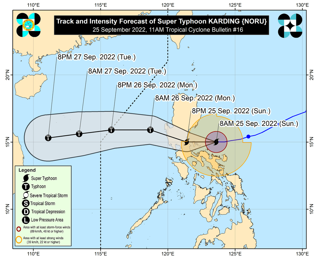
This came as Karding intensified further while heading for the Quezon-Aurora area.
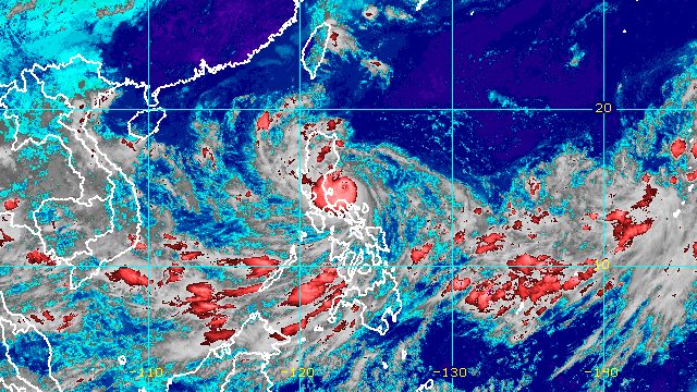
The super typhoon was already 175 kilometers east of Infanta, Quezon, said the Philippine Atmospheric, Geophysical, and Astronomical Services Administration (PAGASA) in a briefing past 11 am on Sunday. It continues to move west at 20 kilometers per hour (km/h).
At that pace, Karding is likely to make landfall in the northern part of Quezon or the southern part of Aurora on Sunday evening. But PAGASA is not ruling out the possibility of the super typhoon making landfall in Quezon’s Polillo Islands in the afternoon.
As of late Sunday morning, Karding’s maximum sustained winds had increased from 185 km/h to 195 km/h, while its gustiness went up to 240 km/h from the previous 230 km/h.
PAGASA said the super typhoon may reach a peak intensity of up to 205 km/h.
Here are the areas under tropical cyclone wind signals as of 11 am on Sunday:
Signal No. 5
Typhoon-force winds (185 km/h or higher), extreme threat to life and property
- Polillo Islands
- extreme northern part of Quezon (northern and central parts of General Nakar, and northeastern part of Infanta)
Signal No. 4
Typhoon-force winds (118 to 184 km/h), significant to severe threat to life and property
- Calaguas Islands
- southern part of Aurora (San Luis, Dingalan, Baler, Maria Aurora)
- northern part of Quezon (rest of General Nakar, rest of Infanta, Real)
- southeastern part of Nueva Ecija (Gabaldon, General Tinio, Gapan City, Peñaranda)
- eastern and central parts of Bulacan (Doña Remedios Trinidad, Norzagaray, San Miguel, San Ildefonso, San Rafael, Angat, San Jose del Monte City)
- northeastern part of Rizal (Rodriguez, Antipolo City, Tanay, San Mateo, Baras)
- extreme northern part of Laguna (Famy, Siniloan, Santa Maria, Pangil)
Signal No. 3
Storm-force winds (89 to 117 km/h), moderate to significant threat to life and property
- central part of Aurora (Dipaculao)
- southeastern part of Nueva Vizcaya (Alfonso Castañeda, Dupax del Sur, Dupax del Norte)
- rest of Nueva Ecija
- Tarlac
- rest of Bulacan
- Pampanga
- Zambales
- Bataan
- Pangasinan
- Metro Manila
- rest of Rizal
- northern and central parts of Laguna (Mabitac, Pakil, Paete, Kalayaan, Lumban, Cavinti, Pagsanjan, Luisiana, Majayjay, Magdalena, Santa Cruz, Pila, Liliw, Nagcarlan, Victoria, Rizal, San Pedro City, Biñan City, Santa Rosa City, Cabuyao City, Calamba City, Los Baños, Bay, Calauan)
- northeastern part of Cavite (Bacoor City, Imus City, Kawit, Dasmariñas City, Carmona, General Mariano Alvarez, General Trias City, Rosario, Silang)
- rest of northern part of Quezon (Mauban)
- northern part of Camarines Norte (Vinzons, Paracale, Jose Panganiban, Capalonga)
Signal No. 2
Gale-force winds (62 to 88 km/h), minor to moderate threat to life and property
- southern part of Isabela (Dinapigue, San Guillermo, Echague, San Agustin, Jones)
- Quirino
- rest of Nueva Vizcaya
- Benguet
- La Union
- rest of Aurora
- rest of Cavite
- Batangas
- rest of Laguna
- central part of Quezon (Calauag, Perez, Alabat, Quezon, Tagkawayan, Guinayangan, Sampaloc, Lucban, Tayabas City, Lucena City, Pagbilao, Padre Burgos, Atimonan, Agdangan, Unisan, Plaridel, Gumaca, Lopez, Pitogo, Dolores, Candelaria, Sariaya, Tiaong, San Antonio, Macalelon, General Luna, Catanauan, Buenavista)
- rest of Camarines Norte
- northern part of Camarines Sur (Del Gallego, Ragay, Lupi, Sipocot, Libmanan, Pamplona, Pasacao, San Fernando, Pili, Minalabac, Ocampo, Tigaon, Cabusao, Magarao, Gainza, Canaman, Camaligan, Milaor, Naga City, Bombon, Calabanga, Tinambac, Siruma, Goa, Lagonoy, San Jose, Garchitorena, Presentacion, Caramoan, Sagñay)
- Catanduanes
Signal No. 1
Strong winds (39 to 61 km/h), minimal to minor threat to life and property
- southern part of Cagayan (Tuao, Solana, Enrile, Tuguegarao City, Iguig, Peñablanca)
- rest of Isabela
- southern part of Apayao (Conner)
- Kalinga
- Abra
- Mountain Province
- Ifugao
- southern part of Ilocos Norte (Nueva Era, Badoc, Pinili, Banna, Batac City, Currimao, Paoay, Marcos)
- Ilocos Sur
- rest of Quezon
- northern part of Occidental Mindoro (Abra de Ilog, Paluan, Mamburao, Santa Cruz) including Lubang Islands
- northern part of Oriental Mindoro (Puerto Galera, San Teodoro, Baco, Calapan City, Naujan, Victoria, Pola, Socorro, Pinamalayan)
- Marinduque
- rest of Camarines Sur
- Albay
- Sorsogon
- Burias Island
- Ticao Island
PAGASA also updated its rainfall forecast as of 11 am on Sunday. Floods and landslides are expected in areas affected by Karding.
Early Sunday afternoon, September 25
Moderate to heavy rain
- Isabela
- Aurora
- Quezon including Polillo Islands
- Catanduanes
- Camarines Norte
- Camarines Sur
Light to moderate rain, with at times heavy rain
- mainland Cagayan
- Quirino
- Nueva Vizcaya
- Marinduque
- Romblon
- rest of Bicol
Early Sunday afternoon, September 25, to early Monday morning, September 26
Heavy to intense rain, with at times torrential rain
- Metro Manila
- Zambales
- Bataan
- Tarlac
- Pampanga
- Nueva Ecija
- Bulacan
- Aurora
- Rizal
- northern part of Quezon including Polillo Islands
Moderate to heavy rain, with at times intense rain
- Isabela
- Nueva Vizcaya
- Quirino
- Benguet
- Ifugao
- Mountain Province
- Pangasinan
- Cavite
- Laguna
- central part of Quezon
- Camarines Norte
Light to moderate rain, with at times heavy rain
- Occidental Mindoro
- Oriental Mindoro
- Marinduque
- rest of Calabarzon
- rest of Bicol
Early Monday morning to early Monday afternoon, September 26
Heavy to intense rain, with at times torrential rain
- Zambales
- Bataan
- Pampanga
- Bulacan
Moderate to heavy rain, with at times intense rain
- Metro Manila
- Pangasinan
- Cavite
- Occidental Mindoro
- rest of Central Luzon
Light to moderate rain, with at times heavy rain
- Mountain Province
- Ifugao
- Benguet
- Quirino
- Nueva Vizcaya
- Oriental Mindoro
- rest of Calabarzon
Karding is also enhancing the southwest monsoon or hanging habagat, which is bringing rain to the Visayas and the rest of Southern Luzon, especially their western sections.

Meanwhile, storm surge warnings remain in effect:
High to very high risk of storm surges
More than 3 meters high
- northern Quezon including Polillo Islands
- Aurora
Moderate to high risk of storm surges
- Camarines Norte
- Pangasinan
- Zambales
- Bulacan
- northern part of Metro Manila
- southern part of La Union
- rest of Quezon
PAGASA warned that the combined effects of storm surges and high waves breaking along the coast may cause “life-threatening and damaging” floods.
A gale warning covering the following seaboards also remains in place:
- eastern seaboards of Central Luzon and Southern Luzon (Aurora, Quezon including Polillo Islands, Camarines Norte, Camarines Sur, Catanduanes) – very rough to high seas, waves 4.1 to 7 meters high, risky for all vessels
- eastern seaboard of Northern Luzon (Cagayan, Isabela), western seaboards of Central Luzon and Southern Luzon (Zambales, Bataan, Cavite, western coast of Batangas), western seaboards of Northern Luzon and Southern Luzon (Pangasinan, Occidental Mindoro) – rough to very rough seas, waves 2.8 to 4.5 meters high, fishing boats should not sail
Karding and the enhanced southwest monsoon will also cause moderate to rough seas in the northern and western seaboards of Luzon that are not under any gale warning, with waves 1.5 to 3.5 meters high, and in the western seaboard of the Visayas, where waves will be 1.2 to 2.5 meters high. These conditions may be risky for small vessels.
After Karding’s expected landfall on Sunday evening, it will cross Central Luzon, then emerge over the West Philippine Sea via the coastal waters of Zambales or Pangasinan by early Monday morning, September 26.
Karding may leave the Philippine Area of Responsibility (PAR) on Monday evening.
Karding is the Philippines’ 11th tropical cyclone for 2022.
It is also the third tropical cyclone for September, after Typhoon Inday (Muifa) and Super Typhoon Josie (Nanmadol). Inday and Josie did not make landfall in the country.
PAGASA expects 7 to 11 tropical cyclones to enter or develop inside PAR from September 2022 to February 2023. Per month, these are the weather bureau’s estimates:
- September 2022 – 2 or 3
- October 2022 – 2 to 4
- November 2022 – 2 or 3
- December 2022 – 1 or 2
- January 2023 – 0 or 1
- February 2023 – 0 or 1
– Rappler.com
Add a comment
How does this make you feel?


There are no comments yet. Add your comment to start the conversation.