SUMMARY
This is AI generated summarization, which may have errors. For context, always refer to the full article.
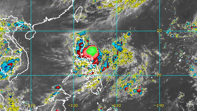
MANILA, Philippines – Tropical Depression Florita is expected to strengthen and start dumping torrential rain on Monday, August 22, which means floods and landslides are expected in areas to be affected by the tropical cyclone.
In a bulletin past 11 pm on Sunday, August 21, the Philippine Atmospheric, Geophysical, and Astronomical Services Administration (PAGASA) said Florita was already 420 kilometers east of Casiguran, Aurora, still over the Philippine Sea.
The tropical depression slightly accelerated, moving west southwest at 20 kilometers per hour from the previous 15 km/h.
It maintained its strength, with maximum sustained winds of 55 km/h and gustiness of up to 70 km/h.
But PAGASA sees Florita strengthening into a tropical storm on Monday morning or afternoon, and then into a severe tropical storm on Tuesday, August 23. Earlier, Florita had only been expected to reach tropical storm status.
The worst rain from Florita is projected to begin Monday evening, though even before that, it will already be bringing some heavy rain to northern provinces. It will be felt just as thousands of schools in the country are returning to face-to-face classes.
Here is PAGASA’s latest rainfall forecast:
Until Monday evening, August 22
Light to moderate rain, with at times heavy rain
- Cagayan
- Isabela
- Batanes
- Aurora
Monday evening, August 22, to Tuesday evening, August 23
Heavy to intense rain, with at times torrential rain
- Cagayan
- Isabela
- Batanes
- Cordillera Administrative Region
- Ilocos Region
Moderate to heavy rain
- rest of Cagayan Valley
- northern part of Aurora
Light to moderate rain, with at times heavy rain
- rest of Central Luzon
In terms of winds, more areas have been placed under Signal No. 1 as of 11 pm on Sunday:
- northern part of Aurora (Dilasag)
- northern and eastern parts of Isabela (Dinapigue, Palanan, Divilacan, Maconacon, San Pablo, Cabagan, Tumauini, Ilagan City, San Mariano, Benito Soliven, Cauayan City, Naguilian, Gamu, Quirino, Delfin Albano, Santo Tomas, Santa Maria, Quezon, Mallig, Burgos, Reina Mercedes, Luna, Aurora, Roxas, Cabatuan, San Manuel)
- eastern part of Cagayan (Peñablanca, Baggao, Gattaran, Lal-lo, Gonzaga, Santa Ana, Santa Teresita, Buguey, Aparri, Camalaniugan, Alcala, Amulung, Iguig, Solana, Tuguegarao City, Enrile)
Areas under Signal No. 1 should expect strong winds, or winds of 39 to 61 km/h.
PAGASA said it could raise Signal No. 2 for areas in the eastern part of Northern Luzon as early as Monday morning.
Since Florita is now seen to eventually intensify into a severe tropical storm, the highest possible tropical cyclone wind signal to be raised is Signal No. 3.
The weather bureau also said Florita will start enhancing the southwest monsoon or hanging habagat on Monday, which would bring gusts to these areas:
- Bicol
- Batangas
- Occidental Mindoro
- Oriental Mindoro
- Marinduque
- Romblon
- Northern Samar
- Aklan
Also on Monday, Florita will trigger moderate to rough seas in the northern and eastern seaboards of Luzon. Waves will be 1.2 to 3.1 meters high, making conditions risky for small vessels.
PAGASA said Florita could reach a peak intensity of 95 km/h on Tuesday afternoon or evening, right before making landfall in the east coast of Cagayan or the northern part of Isabela.
Then Florita could cross the Babuyan Channel and pass very close to or make landfall in Babuyan Islands early Wednesday morning, August 24, before emerging over the West Philippine Sea.
The weather bureau added that Florita may slightly weaken while crossing the northern part of Northern Luzon “due to frictional effects of the rugged terrain,” but it will “likely remain a high-end tropical storm or a low-end severe tropical storm.”
Florita, the country’s sixth tropical cyclone for 2022, is expected to leave the Philippine Area of Responsibility on Wednesday.

– Rappler.com
Add a comment
How does this make you feel?


There are no comments yet. Add your comment to start the conversation.