SUMMARY
This is AI generated summarization, which may have errors. For context, always refer to the full article.
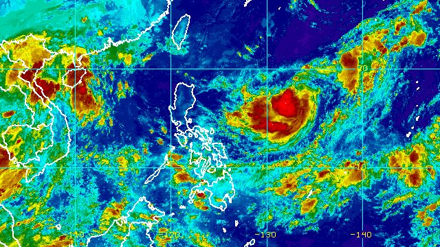
MANILA, Philippines – Tropical Storm Inday maintained its strength while moving over the Philippine Sea before dawn on Thursday, September 8.
The Philippine Atmospheric, Geophysical, and Astronomical Services Administration (PAGASA) said in its 5 am bulletin on Thursday that Inday continues to have maximum sustained winds of 75 kilometers per hour and gustiness of up to 90 km/h.
The tropical storm was last spotted 1,215 kilometers east of Central Luzon, moving west at a slightly faster 15 km/h from the previous 10 km/h.
PAGASA said Inday is “unlikely to directly affect the weather condition in the country.” There are no rainfall warnings or tropical cyclone wind signals in effect due to the tropical storm.
But starting Saturday, September 10, the seaboards of extreme Northern Luzon might have moderate to rough seas due to Inday. Waves may be 1.5 to 3.5 meters high, making conditions risky for small vessels.
In the next couple of days, Inday is projected to strengthen into a severe tropical storm and then into a typhoon as it continues crossing the Philippine Sea.
“The possibility of rapid intensification within the forecast period is not ruled out,” added PAGASA.
Inday is seen to exit the Philippine Area of Responsibility (PAR) on Sunday, September 11, or Monday, September 12.
It may turn more northward on Monday, toward Japan’s Ryukyu Islands and the East China Sea, said the weather bureau.
Inday is the Philippines’ ninth tropical cyclone for 2022 and the first for September.
PAGASA expects 7 to 11 tropical cyclones to enter or develop inside PAR from September 2022 to February 2023. Per month, these are the weather bureau’s estimates:
- September 2022 – 2 or 3
- October 2022 – 2 to 4
- November 2022 – 2 or 3
- December 2022 – 1 or 2
- January 2023 – 0 or 1
- February 2023 – 0 or 1

Meanwhile, four regions in the Philippines are expected to have scattered rain showers and thunderstorms on Thursday due to the intertropical convergence zone (ITCZ).
The ITCZ is a belt near the equator where the trade winds of the Northern Hemisphere and Southern Hemisphere meet, usually causing low pressure areas or thunderstorms.
These are the affected regions on Thursday:
- Western Visayas
- Zamboanga Peninsula
- Northern Mindanao
- Bangsamoro Autonomous Region in Muslim Mindanao
The rest of the country will only have isolated rain or localized thunderstorms. – Rappler.com
Add a comment
How does this make you feel?


There are no comments yet. Add your comment to start the conversation.