SUMMARY
This is AI generated summarization, which may have errors. For context, always refer to the full article.

MANILA, Philippines – Tropical Storm Kabayan (Jelawat) was bringing heavy rain to parts of Mindanao and the Visayas even before its expected landfall on Monday, December 18.
As of 4 am on Monday, Kabayan was already over the coastal waters of Caraga, Davao Oriental, moving west northwest at 15 kilometers per hour (km/h).
It continues to have maximum sustained winds of 65 km/h and gustiness of up to 80 km/h.
The Philippine Atmospheric, Geophysical, and Astronomical Services Administration (PAGASA) said in a briefing past 5 am on Monday that it observed a “southward shift” in the tropical storm’s track.
Kabayan is expected to make landfall in Davao Oriental or the southern part of Surigao del Sur on Monday morning.
The following areas affected by rain from the tropical storm should watch out for floods and landslides:
Monday, December 18
- 100-200 millimeters (mm): Surigao del Sur, Surigao del Norte, Dinagat Islands, Agusan del Sur, and northern parts of Davao del Norte, Davao de Oro, and Davao Oriental
- 50-100 mm: Central Visayas, Biliran, Leyte, Southern Leyte, Zamboanga del Norte, Northern Mindanao, Davao City, Cotabato, Lanao del Sur, and rest of Caraga, Davao Oriental, Davao de Oro, and Davao del Norte
Tuesday, December 19
- 50-100 mm: mainland Palawan, Cuyo Islands, Cagayancillo Islands, Kalayaan Islands
Earlier, PAGASA warned that the shear line will also continue to bring rain to Bicol and Quezon on Monday. Floods and landslides are possible as well.
ALSO ON RAPPLER
- In This Economy: Learning losses sa Pilipinas, maaagapan pa ba?
- Wesley So bags over P5 million despite loss to Magnus Carlsen in CCT Finals
- Who’s dating who: Relationship reveals, breakups in PH showbiz in 2023
Tropical cyclone wind signals are in effect for more areas as of 5 am on Monday. Below is the full list.
Signal No. 2
Gale-force winds (62 to 88 km/h), minor to moderate threat to life and property
- Dinagat Islands
- Surigao del Norte including Siargao and Bucas Grande Islands
- Surigao del Sur
- northern part of Agusan del Norte (Kitcharao, Jabonga, Santiago, Cabadbaran City, Remedios T. Romualdez, Tubay)
- eastern part of Agusan del Sur (Trento, Bunawan, San Francisco, Rosario, Prosperidad, Bayugan City, Sibagat)
- northern part of Davao Oriental (Boston, Cateel)
Signal No. 1
Strong winds (39 to 61 km/h), minimal to minor threat to life and property
- southern part of mainland Palawan (Sofronio Española, Brooke’s Point, Bataraza, Balabac, Rizal, Quezon, Narra)
- Cagayancillo Islands
- Southern Leyte
- Leyte
- southern part of Samar (Basey, Santa Rita, Marabut, Talalora, Villareal, Pinabacdao)
- southern part of Eastern Samar (Maydolong, Borongan City, Quinapondan, Guiuan, Lawaan, Balangiga, Llorente, Giporlos, Salcedo, Balangkayan, General MacArthur, Hernani, Mercedes)
- Cebu including Camotes and Bantayan Islands
- Bohol
- Siquijor
- Negros Oriental
- Negros Occidental
- Guimaras
- rest of Agusan del Norte
- rest of Agusan del Sur
- central part of Davao Oriental (Baganga, Manay, Caraga, Tarragona, Lupon, Banaybanay)
- Davao de Oro
- Davao del Norte
- Davao City
- Camiguin
- Misamis Oriental
- Misamis Occidental
- Bukidnon
- Lanao del Norte
- Lanao del Sur
- northern part of Maguindanao del Norte (Buldon, Barira, Matanog, Parang, Sultan Kudarat, Sultan Mastura)
- northern part of Cotabato (Arakan, Carmen, Banisilan, Alamada, President Roxas, Kabacan, Matalam, Antipas, Magpet, Libungan, Pigkawayan)
- northern and central parts of Zamboanga del Norte (Siayan, Sindangan, Jose Dalman, Manukan, President Manuel A. Roxas, Sergio Osmeña Sr., Katipunan, Dipolog City, Polanco, Mutia, Piñan, Dapitan City, Sibutad, La Libertad, Rizal, Siocon, Baliguian, Gutalac, Labason, Kalawit, Tampilisan, Liloy, Salug, Godod, Bacungan)
- Zamboanga del Sur
- Zamboanga Sibugay
PAGASA added that the surge of the northeast monsoon or amihan will cause gusty conditions in areas not under tropical cyclone wind signals, generally in most of Luzon and the Visayas, from Monday to Tuesday, December 19.

The weather bureau also issued a new gale warning at 5 am on Monday due to Kabayan and the surge of the northeast monsoon. Travel is risky for small vessels in these seaboards:
- seaboard of Northern Luzon – rough to very rough seas, waves 2.8 to 5 meters high
- eastern and central seaboards of the Visayas – rough to very rough seas, waves 2.8 to 4.5 meters high
- eastern seaboards of Central Luzon, Southern Luzon, and Mindanao – rough to very rough seas, waves 2.8 to 4.5 meters high
Moderate to rough seas are also seen in the western seaboards of Central Luzon and Southern Luzon, western and northern seaboards of Mindanao, and remaining seaboard of the Visayas. PAGASA advised small vessels to take precautionary measures.
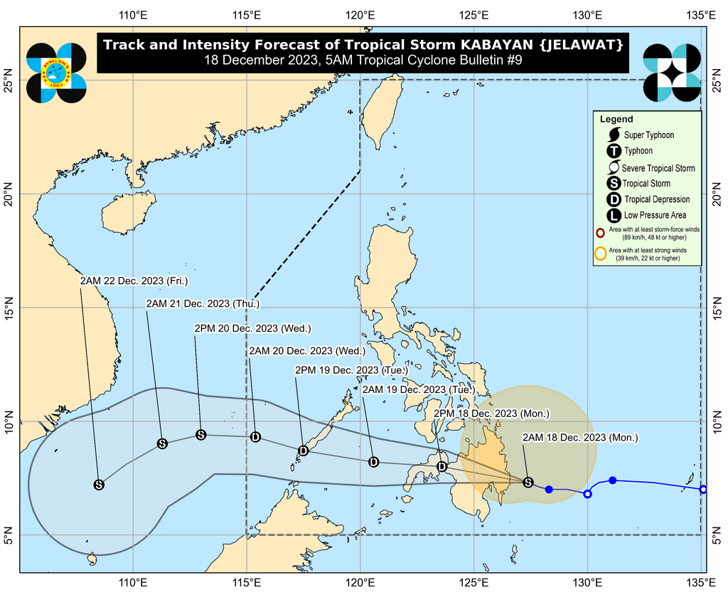
After its expected landfall, Kabayan is seen to “cross the rugged terrain of Mindanao” then emerge over the Sulu Sea between Monday afternoon and evening.
During that period, Kabayan might weaken back into a tropical depression or even a low pressure area “due to frictional effects associated with landfall,” PAGASA explained.
“Although in such a case, redevelopment may still occur over the Sulu Sea,” added the weather bureau.
Kabayan could then move across the Sulu Sea, south of Palawan’s Cagayancillo Islands, followed by another landfall in the central or southern part of Palawan – as a tropical depression – by Tuesday morning or afternoon.
Afterwards, it is expected to emerge over the West Philippine Sea, then pass near or over Kalayaan Islands between Tuesday evening and Wednesday morning, December 20.
PAGASA reiterated that Kabayan’s projected track and intensity “may still change given its nature and strength.”
Kabayan is the Philippines’ 11th tropical cyclone for 2023 and the first for December.
PAGASA previously estimated that one or two tropical cyclones could form within or enter the Philippine Area of Responsibility in December. – Rappler.com
Add a comment
How does this make you feel?


There are no comments yet. Add your comment to start the conversation.