SUMMARY
This is AI generated summarization, which may have errors. For context, always refer to the full article.
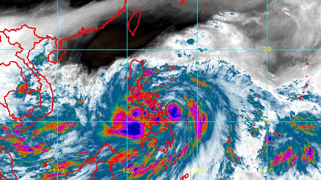
MANILA, Philippines – Tropical Storm Paeng (Nalgae) accelerated further early Friday afternoon, October 28, moving closer to the Eastern Samar-Northern Samar area.
Paeng was last spotted 155 kilometers east northeast of Borongan City, Eastern Samar, or 245 kilometers east southeast of Catarman, Northern Samar.
The Philippine Atmospheric, Geophysical, and Astronomical Services Administration (PAGASA) said in its 2 pm bulletin on Friday that Paeng is moving west at 30 kilometers per hour, slightly faster than its previous speed of 25 km/h.
The tropical storm is projected to move west or west northwest in the next 12 hours, or for the rest of Friday.
Since Paeng’s movement is westward, PAGASA is now looking at a possible landfall in Eastern Samar or Northern Samar on Friday afternoon or evening. The tropical storm may also just pass close to these provinces.
Then Paeng could head west northwest and cross Bicol from Friday evening to Saturday morning, October 29, followed by another landfall in the east coast of Quezon, including Polillo Islands, or Aurora between Saturday afternoon and evening.
As of early Friday afternoon, Paeng continued to have maximum sustained winds of 75 km/h and gustiness of up to 90 km/h. It is still expected to intensify into a severe tropical storm on Friday.
PAGASA maintained the following rainfall forecast for Paeng:
Friday, October 28, to early Saturday morning, October 29
Heavy to intense rain, with at times torrential rain
- Bicol
- Eastern Visayas
Moderate to heavy rain, with at times intense rain
- Quezon
- Mimaropa
- rest of Visayas
- Caraga
- Zamboanga Peninsula
- Bangsamoro Autonomous Region in Muslim Mindanao
- Northern Mindanao
Light to moderate rain, with at times heavy rain
- Metro Manila
- Cagayan Valley
- rest of Calabarzon
- Aurora
- rest of Mindanao
Saturday morning, October 29, to Sunday morning, October 30
Heavy to intense rain, with at times torrential rain
- Calabarzon
- Bicol
- Aurora
- Isabela
- Nueva Vizcaya
- Quirino
Moderate to heavy rain, with at times intense rain
- Metro Manila
- mainland Cagayan
- Cordillera Administrative Region
- rest of Central Luzon
- Marinduque
- Romblon
- Occidental Mindoro
- Oriental Mindoro
- Western Visayas
Light to moderate rain, with at times heavy rain
- rest of Luzon
- rest of Visayas
- Zamboanga Peninsula
The weather bureau said areas covered by the rainfall forecast may be updated in its next bulletins “should there be significant shifts in the track and intensity forecast of Paeng.”
The rain has triggered deadly floods and landslides. In Maguindanao del Norte, at least 13 were reported dead on Friday.
PAGASA updated the list of areas under tropical cyclone wind signals as of 2 pm on Friday:
Signal No. 2
Gale-force winds (62 to 88 km/h), minor to moderate threat to life and property
- Catanduanes
- Albay
- Sorsogon
- Masbate including Ticao and Burias Islands
- Camarines Sur
- Camarines Norte
- Marinduque
- northern part of Romblon (Calatrava, San Andres, San Agustin, Romblon, Corcuera, Banton, Concepcion, Cajidiocan, San Fernando, Magdiwang)
- Quezon including Polillo Islands
- eastern part of Batangas (Lobo, Taysan, Rosario, Padre Garcia, San Juan, Lipa City, Santo Tomas)
- southeastern part of Laguna (Alaminos, San Pablo City, Rizal, Nagcarlan, Majayjay, Luisiana, Cavinti, Paete, Kalayaan, Santa Maria, Mabitac, Pakil, Famy, Siniloan, Pangil, Lumban, Liliw)
- Northern Samar
- Eastern Samar
- Samar
- Biliran
- northern part of Leyte (San Isidro, Calubian, Tabango, Leyte, Capoocan, Carigara, Barugo, San Miguel, Babatngon, Tacloban City, Alangalang, Santa Fe, Palo, Tanauan, Dagami, Pastrana, Jaro, Kananga, Villaba, Tunga, Tabontabon, Tolosa)
Signal No. 1
Strong winds (39 to 61 km/h), minimal to minor threat to life and property
- rest of Romblon
- rest of Laguna
- Rizal
- Occidental Mindoro including Lubang Islands
- Oriental Mindoro
- Calamian Islands
- Cuyo Islands
- rest of Batangas
- Cavite
- Metro Manila
- Bataan
- Pampanga
- Bulacan
- Tarlac
- Nueva Ecija
- Aurora
- Zambales
- Pangasinan
- La Union
- Benguet
- Nueva Vizcaya
- Quirino
- central and southern parts of Isabela (San Agustin, Jones, Santiago City, Cordon, Echague, Dinapigue, San Mariano, San Guillermo, Angadanan, Cauayan City, Benito Soliven, Ramon, San Isidro, Alicia, San Mateo, Cabatuan, Luna, Reina Mercedes, Naguilian, Palanan, Aurora, Burgos, San Manuel, Gamu, Ilagan City, Divilacan)
- Ifugao
- southern part of Ilocos Sur (Sugpon, Cervantes, Alilem, Suyo, Tagudin, Santa Cruz, Sigay)
- southwestern part of Mountain Province (Bauko, Sabangan, Tadian)
- Southern Leyte
- Cebu including Bantayan and Camotes Islands
- Bohol
- Negros Occidental
- Negros Oriental
- Guimaras
- Aklan
- Antique
- Capiz
- Iloilo
- Siquijor
- rest of Leyte
- Dinagat Islands
- Surigao del Norte including Siargao and Bucas Grande Islands
- northern part of Surigao del Sur (Carrascal, Cantilan, Madrid, Carmen, Lanuza, Cortes, Tandag City, Bayabas, Cagwait, San Miguel, Tago, Marihatag)
- Agusan del Norte
- northeastern part of Agusan del Sur (Sibagat)
- Camiguin
- eastern part of Misamis Oriental (Gingoog City, Magsaysay, Medina, Talisayan, Balingoan, Kinoguitan)
The highest possible wind signal is Signal No. 3 since Paeng is expected to strengthen into a severe tropical storm.
Paeng is also enhancing the surge of the northeast monsoon or hanging amihan, which is bringing strong winds to these areas:
- Batanes
- Babuyan Islands
- northern and eastern parts of mainland Cagayan
- eastern part of Isabela
- Ilocos Norte
- Ilocos Sur
- northern part of Apayao

PAGASA also warned that there is a minimal to moderate risk of storm surges up to 2 meters high, which may cause floods in the “low-lying and exposed coastal areas” of the following:
- Bicol
- Quezon including Polillo Islands
- eastern part of Aurora
- northern and eastern parts of Northern Samar
- eastern part of Eastern Samar
Due to both Paeng and the northeast monsoon, a gale warning which was issued at 5 am on Friday remains in effect. Rough to very rough seas are expected in these seaboards:
- eastern seaboards of Southern Luzon and Visayas (northern and eastern coasts of Quezon including Polillo Islands, Camarines Norte, northern and eastern coasts of Camarines Sur, Catanduanes, eastern coast of Albay, eastern coast of Sorsogon, Northern Samar, Eastern Samar) – waves 3.4 to 6 meters high
- eastern seaboards of Northern Luzon and Central Luzon (eastern coast of Cagayan, Isabela, Aurora) – waves 3.1 to 5.5 meters high
- northern and western seaboards of Northern Luzon (Batanes, northern coast of Cagayan including Babuyan Islands, Ilocos Norte, Ilocos Sur, La Union, Pangasinan) – waves 3.1 to 5.5 meters high
- eastern seaboard of Mindanao (eastern coast of Surigao del Norte including Siargao and Bucas Grande Islands, eastern coast of Dinagat Islands, Surigao del Sur, eastern coast of Davao Oriental) – waves 2.8 to 4.5 meters high
PAGASA advised fishing boats and other small vessels not to sail, and larger vessels to watch out for big waves. Sea trips have been canceled in areas affected by Paeng.
Paeng is the Philippines’ 16th tropical cyclone for 2022 and the fourth for October. PAGASA earlier said there may be up to four tropical cyclones during the month. – Rappler.com
Add a comment
How does this make you feel?


There are no comments yet. Add your comment to start the conversation.