SUMMARY
This is AI generated summarization, which may have errors. For context, always refer to the full article.
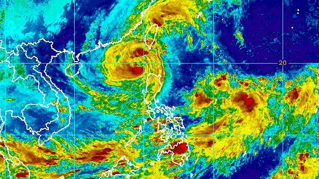
MANILA, Philippines – Typhoon Neneng (Nesat) maintained its strength over the West Philippine Sea while making its way out of the Philippine Area of Responsibility (PAR) late Sunday afternoon, October 16.
Neneng was already 210 kilometers west northwest of Calayan, Cagayan, said the Philippine Atmospheric, Geophysical, and Astronomical Services Administration (PAGASA) in a briefing past 5 pm on Sunday.
The typhoon slowed down further, moving west northwest at 15 kilometers per hour from the previous 20 km/h. It is still expected to leave PAR by Sunday evening.
Neneng continues to have maximum sustained winds of 120 km/h and gustiness of up to 150 km/h. Earlier, it underwent “extreme rapid intensification,” according to PAGASA.
The typhoon is still bringing rain on Sunday evening even as it is about to exit PAR.
Moderate to heavy rain
- Batanes
- Abra
- Benguet
- Ilocos Norte
- Ilocos Sur
Light to moderate rain, with at times heavy rain
- Babuyan Islands
- rest of Cordillera Administrative Region
- rest of Ilocos Region
PAGASA also said Neneng’s trough or extension “and the convergence of its circulation with the southwesterly winds induced by the typhoon” could bring occasional rain to the following areas:
- western part of Mimaropa
- western part of Visayas
- northern and western parts of Mindanao
Neneng earlier dumped torrential rain, triggering floods and landslides. It made landfall in Calayan Island as a severe tropical storm at 3:50 am on Sunday.
Meanwhile, there are no more areas under Signal No. 3, which was the highest raised due to Neneng. Here are the areas left under tropical cyclone wind signals as of 5 pm on Sunday:
Signal No. 2
Gale-force winds (62 to 88 km/h), minor to moderate threat to life and property
- Batanes
- western part of Babuyan Islands (Dalupiri Island, Calayan Island, Panuitan Island, Babuyan Island)
- northwestern part of Ilocos Norte (Bangui, Burgos, Pagudpud, Pasuquin, Bacarra)
Signal No. 1
Strong winds (39 to 61 km/h), minimal to minor threat to life and property
- western part of Cagayan (Allacapan, Aparri, Ballesteros, Abulug, Sanchez Mira, Pamplona, Claveria, Santa Praxedes, Rizal, Lasam)
- Apayao
- northern part of Abra (San Juan, Tayum, Langiden, Lagangilang, Danglas, La Paz, Dolores, Lacub, Tineg, Lagayan, Bangued)
- rest of Ilocos Norte
- northern part of Ilocos Sur (Magsingal, San Vicente, Santa Catalina, Sinait, San Ildefonso, Vigan City, Cabugao, Caoayan, San Juan, Bantay, Santo Domingo)
PAGASA added that there may be occasional gusts in most of Southern Luzon and the Visayas, as well as the eastern parts of Central Luzon, due to the induced southwesterly winds.
The weather bureau also issued a new gale warning at 5 pm on Sunday. Neneng is causing rough to very rough seas, with waves 3.7 to 5 meters high, in the following seaboards:
- northern seaboard of Northern Luzon (Batanes, Babuyan Islands, northern coast of Cagayan, Ilocos Norte)
- western seaboard of Northern Luzon (Ilocos Sur, La Union, Pangasinan)
PAGASA advised fishing boats and other small vessels not to sail, and larger vessels to watch out for big waves.
The surge of the northeasterly surface windflow and Neneng may also trigger moderate to rough seas in the western seaboard of Central Luzon and the eastern seaboard of Northern Luzon. Waves could be 2 to 3.5 meters high, making conditions risky for small vessels.

Neneng is the Philippines’ 14th tropical cyclone for 2022 and the second for October.
PAGASA expects 5 to 9 tropical cyclones to enter or develop inside PAR from October 2022 to March 2023. Per month, these are the weather bureau’s estimates:
- October 2022 – 2 to 4
- November 2022 – 2 or 3
- December 2022 – 1 or 2
- January 2023 – 0 or 1
- February 2023 – 0 or 1
- March 2023 – 0 or 1
– Rappler.com
Add a comment
How does this make you feel?


There are no comments yet. Add your comment to start the conversation.