SUMMARY
This is AI generated summarization, which may have errors. For context, always refer to the full article.
MANILA, Philippines – There were no more areas under a tropical cyclone wind signal due to Severe Tropical Storm Paeng (Nalgae) as of 11 pm on Monday, October 31, but its trough or extension may still trigger rain until Tuesday, November 1.
Meanwhile, Tropical Storm Queenie (Banyan) maintained its strength on Monday evening.
Paeng
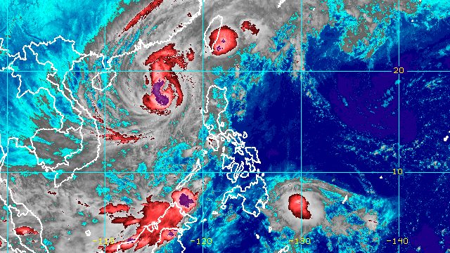
Paeng left the Philippine Area of Responsibility (PAR) at 12:10 pm on Monday, but its wide circulation meant it still had an effect on some areas.
As Paeng continues to move further away, only its trough will be felt.
On Monday evening, the severe tropical storm was already 455 kilometers west of Sinait, Ilocos Sur, still moving north northwest at 15 kilometers per hour (km/h).
The Philippine Atmospheric, Geophysical, and Astronomical Services Administration (PAGASA) said in its 11 pm bulletin that Paeng will maintain its north northwest direction until Tuesday before turning northwest on Wednesday, November 2, and west northwest on Thursday, November 3, while approaching the southern part of China.
Paeng also continues to have maximum sustained winds of 110 km/h and gustiness of up to 135 km/h.
It may intensify into a typhoon within 12 hours, or by Tuesday morning, but “a weakening trend due to cooler seas and increasingly unfavorable atmospheric conditions” could begin by Tuesday evening or on Wednesday.
Light to moderate rain, with at times heavy rain, may still hit the following areas on Tuesday because of Paeng’s trough:
- Mimaropa
- Zambales
- Bataan
- Western Visayas
Signal No. 1 was completely lifted as of 11 pm on Monday. At the height of Paeng’s onslaught, Signal No. 3 was the highest tropical cyclone wind signal in effect.
PAGASA added that Batanes may have strong to gale-force winds from the northeast monsoon or hanging amihan enhanced by Paeng until Tuesday.
The gale warning issued due to Paeng at 5 pm on Monday is still in place for the following seaboards:
- western seaboard of Northern Luzon and Central Luzon (western coast of Ilocos Norte, Ilocos Sur, La Union, Pangasinan, Zambales, Bataan) – rough to very rough seas, waves 4 to 5.5 meters high
- northern and eastern seaboards of Northern Luzon and western and southern seaboards of Southern Luzon (Batanes, Cagayan including Babuyan Islands, northern coast of Ilocos Norte, Isabela, Pampanga, Bulacan, Metro Manila, Cavite, Batangas, Occidental Mindoro including Lubang Islands, Oriental Mindoro, Marinduque, Romblon, northern part of Palawan including Calamian, Cuyo, and Kalayaan Islands) – rough to very rough seas, waves 3.1 to 5 meters high
The weather bureau advised fishing boats and other small vessels not to sail, and larger vessels to watch out for big waves.
Paeng may also cause moderate to rough seas in the western seaboard of the Visayas. Waves could be 1.5 to 3 meters high, which would be risky for small vessels.
Paeng had made landfall five times, all as a severe tropical storm on Saturday, October 29:
- Virac, Catanduanes – 1:10 am
- Caramoan, Camarines Sur – 1:40 am
- Buenavista, Quezon – 6 am
- Santa Cruz, Marinduque – 8:40 am
- Sariaya, Quezon – 1:40 pm
After hitting Quezon for a second time, Paeng crossed Laguna, Cavite, the Metro Manila-Rizal-Bulacan area, Pampanga, and Zambales.
Even before its landfalls in Luzon, Paeng already wreaked havoc in parts of Mindanao and the Visayas.
The death toll from the severe tropical storm rose to 101 on Monday, with 28 of the fatalities still subject to confirmation. More than half of the deaths were reported in the Bangsamoro Autonomous Region in Muslim Mindanao.

Queenie
Meanwhile, Queenie was located 635 kilometers east of Davao City on Monday evening, moving west northwest at a slightly slower 20 km/h from the previous 25 km/h.
PAGASA said the tropical storm will generally move west northwest to northwest toward the Caraga-Eastern Visayas area.
As of Monday evening, Queenie still had maximum sustained winds of 65 km/h and gustiness of up to 80 km/h.
But it may weaken into a tropical depression on Tuesday “due to increasingly unfavorable conditions,” and further weaken into a low pressure area by Thursday or possibly earlier.
Despite Queenie’s weakening trend, PAGASA warned that it may still trigger light to moderate rain, with at times heavy rain, in the next few days.
Tuesday evening, November 1, to Wednesday, November 2
- Caraga
- Eastern Visayas
- Davao Oriental
Thursday, November 3
- Caraga
- Davao Region
- Northern Mindanao
- Eastern Visayas
- Central Visayas
- Bicol
The weather bureau is also not ruling out the possibility of raising Signal No. 1 for the eastern part of Caraga and for some areas in Eastern Visayas as early as Tuesday evening, to warn the public that strong winds are expected from Queenie.
Based on the tropical storm’s latest track and intensity forecast, Signal No. 1 is probably the highest possible wind signal.
Queenie may also cause moderate to rough seas in the eastern seaboard of Mindanao on Tuesday. Waves could be 1.5 to 3 meters high, which would be risky for small vessels.

Paeng and Queenie are the Philippines’ 16th and 17th tropical cyclones for 2022, and the fourth and fifth for October, respectively. – Rappler.com
Add a comment
How does this make you feel?


There are no comments yet. Add your comment to start the conversation.