SUMMARY
This is AI generated summarization, which may have errors. For context, always refer to the full article.
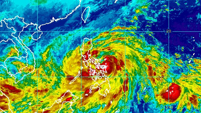
MANILA, Philippines – The initial landfall of Tropical Storm Paeng (Nalgae) may be in Albay or Sorsogon, and no longer in Northern Samar, the weather bureau said past 8 pm on Friday, October 28.
Paeng was already 100 kilometers east northeast of Catarman, Northern Samar, or 165 kilometers east of Juban, Sorsogon, still moving west northwest at 25 kilometers per hour (km/h). It may maintain that direction until Sunday, October 30.
Paeng only passed close to Northern Samar early Friday evening. It could make its first landfall in Albay or Sorsogon late Friday evening or early Saturday morning, October 29, then cross the Bicol peninsula before emerging over Quezon’s coastal waters.
Between Saturday afternoon and evening, Paeng could make another landfall in the east coast of Quezon.
But “considering the southward shift in the forecast track, the landfall scenario may change in the succeeding bulletins,” the Philippine Atmospheric, Geophysical, and Astronomical Services Administration (PAGASA) said.
Paeng maintained its strength early Friday evening, with maximum sustained winds of 85 km/h and gustiness of up to 105 km/h. But it is still seen to intensify into a severe tropical storm within 12 hours.
Rain from Paeng will persist until the weekend, threatening to trigger more floods and landslides.
Friday evening, October 28, to early Saturday morning, October 29
Heavy to intense rain, with at times torrential rain
- Bicol
- Eastern Visayas
Moderate to heavy rain, with at times intense rain
- Quezon
- Mimaropa
- rest of Visayas
- Caraga
- Zamboanga Peninsula
- Bangsamoro Autonomous Region in Muslim Mindanao
- Northern Mindanao
Light to moderate rain, with at times heavy rain
- Metro Manila
- Cagayan Valley
- rest of Calabarzon
- Bulacan
- Pampanga
- Aurora
- rest of Mindanao
Early Saturday morning, October 29, to Sunday morning, October 30
Heavy to torrential rain
- Metro Manila
- Calabarzon
- Aurora
- Bulacan
- Nueva Ecija
- Occidental Mindoro
- Oriental Mindoro
- Romblon
- Marinduque
- Camarines Norte
- Camarines Sur
Moderate to heavy rain, with at times intense rain
- Cagayan Valley
- Cordillera Administrative Region
- rest of Central Luzon
- rest of Bicol
- Western Visayas
Light to moderate rain, with at times heavy rain
- rest of Luzon
- rest of Visayas
- Zamboanga Peninsula
If there are “significant shifts” in Paeng’s track and intensity, areas covered by PAGASA’s rainfall forecast may be updated.
Paeng is causing strong to gale-force winds as well. These are the areas under tropical cyclone wind signals as of 8 pm on Friday:
Signal No. 2
Gale-force winds (62 to 88 km/h), minor to moderate threat to life and property
- Catanduanes
- Albay
- Sorsogon
- Masbate including Ticao Island and Burias Island
- Camarines Sur
- Camarines Norte
- Marinduque
- Quezon including Polillo Islands
- Laguna
- Batangas
- Cavite
- Metro Manila
- Rizal
- Bulacan
- southern part of Aurora (San Luis, Baler, Dingalan, Maria Aurora)
- central and southern parts of Nueva Ecija (Gapan City, San Leonardo, Santo Domingo, Rizal, San Isidro, Laur, Zaragoza, Llanera, Aliaga, Palayan City, Gabaldon, General Mamerto Natividad, Cabanatuan City, Quezon, San Antonio, General Tinio, Santa Rosa, Peñaranda, Jaen, Licab, Bongabon, Cabiao, Talavera)
- central and southern parts of Tarlac (La Paz, Tarlac City, San Jose, Gerona, Mayantoc, Pura, Bamban, Capas, Santa Ignacia, Victoria, Concepcion)
- Pampanga
- Bataan
- central and southern parts of Zambales (Masinloc, Palauig, Iba, Botolan, Cabangan, San Marcelino, Subic, Olongapo City, Castillejos, San Antonio, San Narciso, San Felipe)
- northern and central parts of Oriental Mindoro (Puerto Galera, San Teodoro, Baco, Calapan City, Naujan, Victoria, Pola, Socorro, Pinamalayan, Gloria, Bansud, Bongabong, Roxas)
- northern and central parts of Occidental Mindoro (Sablayan, Santa Cruz, Mamburao, Abra de Ilog, Paluan) including Lubang Islands
- Romblon
- Northern Samar
- Eastern Samar
- Samar
- Biliran
- northern part of Leyte (San Isidro, Calubian, Tabango, Leyte, Capoocan, Carigara, Barugo, San Miguel, Babatngon, Tacloban City, Alangalang, Santa Fe, Palo, Tanauan, Dagami, Pastrana, Jaro, Kananga, Villaba, Tunga, Tabontabon, Tolosa)
Signal No. 1
Strong winds (39 to 61 km/h), minimal to minor threat to life and property
- central and southern parts of Isabela (San Agustin, Jones, Santiago City, Cordon, Echague, Dinapigue, San Mariano, San Guillermo, Angadanan, Cauayan City, Benito Soliven, Ramon, San Isidro, Alicia, San Mateo, Cabatuan, Luna, Reina Mercedes, Naguilian, Palanan, Aurora, Burgos, San Manuel, Gamu, Ilagan City, Divilacan, Roxas, Quirino, Mallig)
- Nueva Vizcaya
- Quirino
- Benguet
- Ifugao
- Mountain Province
- southern part of Ilocos Sur (Sugpon, Cervantes, Alilem, Suyo, Tagudin, Santa Cruz, Sigay, Quirino, Gregorio del Pilar, Salcedo, Santa Lucia)
- La Union
- rest of Aurora
- rest of Nueva Ecija
- rest of Zambales
- Pangasinan
- rest of Tarlac
- rest of Oriental Mindoro
- rest of Occidental Mindoro
- Calamian Islands
- Cuyo Islands
- Southern Leyte
- Cebu including Bantayan and Camotes Islands
- Bohol
- Negros Occidental
- Negros Oriental
- Guimaras
- Aklan
- Antique
- Capiz
- Iloilo
- Siquijor
- rest of Leyte
- Dinagat Islands
- Surigao del Norte including Siargao and Bucas Grande Islands
- northern part of Surigao del Sur (Carrascal, Cantilan, Madrid, Carmen, Lanuza, Cortes, Tandag City, Bayabas, Cagwait, San Miguel, Tago, Marihatag)
- Agusan del Norte
- northeastern part of Agusan del Sur (Sibagat)
- Camiguin
- eastern part of Misamis Oriental (Gingoog City, Magsaysay, Medina, Talisayan, Balingoan, Kinoguitan)
The highest possible wind signal is Signal No. 3 since Paeng is likely to strengthen into a severe tropical storm.
Meanwhile, the surge of the northeast monsoon or hanging amihan is bringing strong winds to these areas:
- Batanes
- Babuyan Islands
- northern and eastern parts of mainland Cagayan
- Ilocos Norte
- northern part of Apayao

PAGASA also warned that there is a minimal to moderate risk of storm surges up to 2 meters high, which may cause floods in the “low-lying and exposed coastal areas” of the following:
- Bicol
- Marinduque
- Quezon including Polillo Islands
- eastern part of Aurora
- northern and eastern parts of Northern Samar
- eastern part of Eastern Samar
For coastal waters, this gale warning issued at 5 pm on Friday due to Paeng and the northeast monsoon is still in effect:
- eastern and southern seaboards of Southern Luzon and eastern seaboard of Visayas (Quezon including Polillo Islands, Marinduque, Romblon, southern coast of Batangas, Oriental Mindoro, Camarines Norte, Camarines Sur, Catanduanes, Albay, Sorsogon, Masbate including Burias and Ticao Islands, Northern Samar, Eastern Samar, Biliran) – very rough to high seas, waves 4.5 to 6.5 meters high
- eastern seaboards of Northern Luzon and Central Luzon (eastern coast of Cagayan, Isabela, Aurora) – very rough seas, waves 4.5 to 6 meters high
- northern and western seaboards of Northern Luzon (Batanes, northern coast of Cagayan including Babuyan Islands, Ilocos Norte, Ilocos Sur, La Union, Pangasinan, Zambales) – rough to very rough seas, waves 3.1 to 5.5 meters high
- eastern seaboard of Mindanao (eastern coast of Surigao del Norte including Siargao and Bucas Grande Islands, eastern coast of Dinagat Islands, Surigao del Sur, eastern coast of Davao Oriental) – rough to very rough seas, waves 2.8 to 4.5 meters high
“Rough to high sea conditions are risky for all types of sea vessels. Mariners are advised to remain in port or take shelter in port until winds and waves subside,” PAGASA said.
Paeng is the Philippines’ 16th tropical cyclone for 2022 and the fourth for October. PAGASA earlier said there may be up to four tropical cyclones during the month. – Rappler.com
Add a comment
How does this make you feel?


There are no comments yet. Add your comment to start the conversation.