SUMMARY
This is AI generated summarization, which may have errors. For context, always refer to the full article.
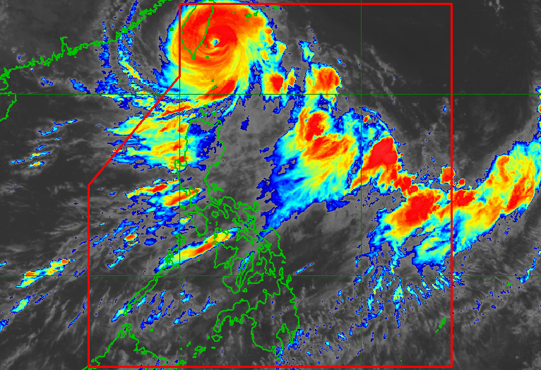
MANILA, Philippines – Typhoon Hanna (Haikui) continued to intensify near the coast of southern Taiwan on Sunday morning, September 3, with its maximum sustained winds increasing from 150 kilometers per hour to 155 km/h.
The typhoon’s gustiness is now up to 190 km/h from the previous 185 km/h.
It also slowed down, moving west at only 10 km/h from 20 km/h. Since it decelerated, its location barely changed, at 220 kilometers north northeast of Itbayat, Batanes.
Batanes and the entire Babuyan Islands are under Signal No. 1 as of 11 am on Sunday. This means Hanna is bringing strong winds to these areas.
The Philippine Atmospheric, Geophysical, and Astronomical Services Administration (PAGASA) also updated its rainfall forecast. Aside from Batanes, the northern part of Babuyan Islands is also seeing moderate to heavy rain from the typhoon on Sunday.
Hanna will not make landfall in the Philippines, but it will hit the east coast of southern Taiwan on Sunday afternoon or evening. Taiwan is within the Philippine Area of Responsibility (PAR).
“Slight intensification shortly before landfall is not ruled out, although this window is quickly closing as the typhoon moves closer to land,” PAGASA said.
The typhoon will “cross the rugged terrain of southern Taiwan” on Sunday evening, “resulting in considerable weakening.”
Then it may emerge over the Taiwan Strait and leave PAR late Sunday evening or early Monday morning, September 4.
Outside PAR, it may slow down over the Taiwan Strait, and also weaken further.
PAGASA said Hanna could make its final landfall along the coast of Guangdong or Fujian in China on Tuesday, September 5, as a severe tropical storm. By late Wednesday, September 6, or Thursday, September 7, it could weaken into a remnant low.

Hanna also continues to enhance the southwest monsoon or habagat. Below is PAGASA’s latest rainfall forecast for the enhanced southwest monsoon, issued at 11 am on Sunday.
Sunday, September 3
- 100-200 millimeters (mm): Ilocos Region, Abra, Benguet, Zambales, Bataan, Occidental Mindoro
- 50-100 mm: Metro Manila, rest of Cordillera Administrative Region, Tarlac, Nueva Ecija, Pampanga, Bulacan, Rizal, Cavite, Batangas, Romblon, northern part of Palawan including Calamian and Cuyo islands, Antique
Monday, September 4
- 100-200 mm: Ilocos Region, Zambales, Bataan
- 50-100 mm: Metro Manila, Abra, Benguet, Tarlac, Nueva Ecija, Pampanga, Bulacan, Rizal, Cavite, Batangas, Occidental Mindoro, northern part of Palawan including Calamian and Cuyo islands, Antique
Tuesday, September 5
- 50-100 mm: Metro Manila, Ilocos Region, Abra, Benguet, Zambales, Bataan, Tarlac, Nueva Ecija, Pampanga, Bulacan, Rizal
The enhanced southwest monsoon is also causing gusty conditions in the following areas:
Sunday, September 3
- Babuyan Islands, Ilocos Region, Cordillera Administrative Region, Nueva Vizcaya, Zambales, Pampanga, Bataan, Aurora, Bulacan, Metro Manila, Calabarzon, Mimaropa, Bicol, Western Visayas, northern part of Eastern Visayas
Monday, September 4
- Batanes, Babuyan Islands, Ilocos Region, Abra, Benguet, Apayao, Nueva Vizcaya, Zambales, Pampanga, Bataan, Aurora, Bulacan, Metro Manila, Calabarzon, most of Mimaropa, most of Bicol, most of Western Visayas
Tuesday, September 5
- Batanes, Babuyan Islands, Ilocos Region, Zambales, Bataan, Cavite, northern part of Quezon, Lubang Island, Romblon, Kalayaan Islands
ALSO ON RAPPLER
- Chot Reyes ‘stepping aside’ as Gilas Pilipinas wraps up FIBA World Cup run
- Clarkson gives Chot props for putting ‘everything on the line’
- ‘We did it’: Carlik Jones basks in glory of South Sudan’s 1st Olympic appearance
- At the party, cheers! Meet the fans behind your local K-pop cupsleeve events
Hanna and the enhanced southwest monsoon are affecting coastal waters, too. PAGASA issued another gale warning at 11 am on Sunday, saying that rough to very rough waters are seen in these seaboards:
- seaboards of extreme Northern Luzon (Batanes, Babuyan Islands) – waves 2.8 to 5 meters high
- western seaboard of Northern Luzon, Central Luzon, and Southern Luzon (Ilocos Norte, Ilocos Sur, La Union, Pangasinan, Zambales, Bataan, Occidental Mindoro including Lubang Island, northern part of Palawan including Calamian and Kalayaan Islands) – waves 2.8 to 4.5 meters high
- southern seaboard of Southern Luzon and western seaboard of Visayas (Oriental Mindoro, Marinduque, Romblon, Antique, Aklan) – waves 2.8 to 4.5 meters high
- eastern seaboard of Northern Luzon and Central Luzon (Cagayan, Isabela, Aurora) – waves 2.8 to 4.5 meters high
The weather bureau advised fishing boats and other small vessels not to sail, and larger vessels to watch out for big waves.
Hanna is the Philippines’ eighth tropical cyclone for 2023.
For the next 6 months, PAGASA estimated that 6 to 9 tropical cyclones may form within or enter PAR:
- September 2023 – 2 or 3
- October 2023 – 2 or 3
- November 2023 – 1 or 2
- December 2023 – 1 or 2
- January 2024 – 0 or 1
- February 2024 – 0 or 1
– Rappler.com
Add a comment
How does this make you feel?


There are no comments yet. Add your comment to start the conversation.