SUMMARY
This is AI generated summarization, which may have errors. For context, always refer to the full article.
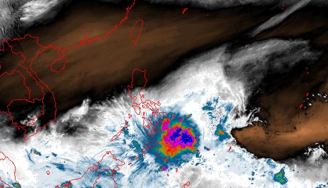
MANILA, Philippines – Kabayan strengthened from a tropical depression into a tropical storm on Sunday evening, December 17, prompting the weather bureau to raise Signal No. 2 in parts of Mindanao and place more areas under Signal No. 1.
Kabayan was also given the international name Jelawat, a name contributed by Malaysia which refers to a type of fish.
The maximum sustained winds of Kabayan increased from 55 kilometers per hour to 65 km/h, said the Philippine Atmospheric, Geophysical, and Astronomical Services Administration (PAGASA) in a bulletin released past 11 pm on Sunday.
Its gustiness is now up to 80 km/h from 70 km/h.
As of 10 pm, the tropical storm was already 275 kilometers east of Davao City, moving west northwest at a slightly faster 15 km/h from 10 km/h earlier in the evening.
It is still expected to make landfall in Surigao del Sur or Davao Oriental by Monday morning, December 18, at the latest.
Here are the areas under tropical cyclone wind signals as of 11 pm on Sunday:
Signal No. 2
Gale-force winds (62 to 88 km/h), minor to moderate threat to life and property
- Dinagat Islands
- Surigao del Norte including Siargao and Bucas Grande Islands
- Surigao del Sur
- northern part of Agusan del Norte (Kitcharao, Jabonga, Santiago, Cabadbaran City, Remedios T. Romualdez, Tubay)
- eastern part of Agusan del Sur (Trento, Bunawan, San Francisco, Rosario, Prosperidad, Bayugan City, Sibagat)
- northern part of Davao Oriental (Boston, Cateel)
Signal No. 1
Strong winds (39 to 61 km/h), minimal to minor threat to life and property
- Southern Leyte
- Leyte
- southern part of Samar (Basey, Santa Rita, Marabut, Talalora, Villareal, Pinabacdao)
- southern part of Eastern Samar (Maydolong, Borongan City, Quinapondan, Guiuan, Lawaan, Balangiga, Llorente, Giporlos, Salcedo, Balangkayan, General MacArthur, Hernani, Mercedes)
- Cebu including Camotes and Bantayan Islands
- Bohol
- Siquijor
- Negros Oriental
- Negros Occidental
- rest of Agusan del Norte
- rest of Agusan del Sur
- central part of Davao Oriental (Baganga, Manay, Caraga)
- Davao de Oro
- Davao del Norte
- Davao City
- Camiguin
- Misamis Oriental
- Misamis Occidental
- Lanao del Norte
- Lanao del Sur
- northern part of Maguindanao del Norte (Buldon, Barira, Matanog)
- northern part of Cotabato (Arakan, Carmen, Banisilan, Alamada, President Roxas, Kabacan, Matalam, Antipas, Magpet)
- northern part of Zamboanga del Sur (Midsalip, Labangan, Tukuran, Aurora, Sominot, Ramon Magsaysay, Tambulig, Dumingag, Mahayag, Josefina, Molave)
- northeastern part of Zamboanga del Norte (Siayan, Sindangan, Jose Dalman, Manukan, President Manuel A. Roxas, Sergio Osmeña Sr., Katipunan, Dipolog City, Polanco, Mutia, Piñan, Dapitan City, Sibutad, La Libertad, Rizal)
PAGASA also said the surge of the northeast monsoon or amihan will cause gusty conditions until Monday in Batanes, Babuyan Islands, Ilocos Norte, Ilocos Sur, Aurora, Bataan, Bulacan, Rizal, Quezon, Lubang Island, Marinduque, Cuyo Islands, Bicol, Visayas, northern and eastern parts of mainland Cagayan, eastern parts of Isabela and Nueva Ecija, and parts of the Cordillera Administrative Region, Zambales, Pampanga, Cavite, Occidental Mindoro, and Oriental Mindoro.
ALSO ON RAPPLER
- Veteran actor Ronaldo Valdez dies at 76
- LOOK: Metro Manila Film Festival 2023 Parade of Stars
- Mapua collapses late in NCAA finals Game 3 as San Beda wins 23rd men’s basketball title
The weather bureau also updated its rainfall forecast for Kabayan, covering the next two days. Floods and landslides are likely in areas affected by the tropical storm.
Sunday night, December 17, to Monday night, December 18
- Above 200 millimeters (mm): northern part of Surigao del Sur
- 100-200 mm: rest of Surigao del Sur, Surigao del Norte, Dinagat Islands, Camiguin, Southern Leyte
- 50-100 mm: Leyte; Biliran; Bohol; northern parts of Davao de Oro, Davao del Norte, and Davao Oriental; southern parts of Eastern Samar and Samar; rest of Caraga; rest of Northern Mindanao
Monday night, December 18, to Tuesday night, December 19
- 100-200 mm: Surigao del Sur, Surigao del Norte, Agusan del Norte, eastern part of Agusan del Sur, Dinagat Islands
- 50-100 mm: Visayas, Northern Mindanao, rest of Caraga
Meanwhile, the shear line will continue to bring rain to Bicol and Quezon on Monday, PAGASA said in a separate advisory on Sunday evening. The two areas should be on alert for possible floods and landslides, too.
For coastal waters, a gale warning remains in effect for the seaboard of Northern Luzon and the eastern seaboards of the Visayas and Mindanao. Travel is risky for small vessels.
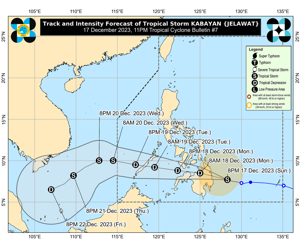
After its expected landfall, Kabayan is seen to “cross the rugged terrain of Mindanao” then emerge over the Bohol Sea or the Sulu Sea between Monday noon and evening.
During that period, Kabayan might weaken back into a tropical depression or even a low pressure area “due to frictional effects associated with landfall,” PAGASA explained.
“Although in such a case, redevelopment may still occur over the Sulu Sea,” added the weather bureau.
Kabayan could then move across the Sulu Sea, south of Palawan’s Cuyo Islands, followed by another landfall in the central or southern part of Palawan – as a tropical depression – by Tuesday morning or afternoon, December 19.
Afterwards, it is expected to emerge over the West Philippine Sea, then pass near or over Kalayaan Islands between Tuesday evening and Wednesday morning, December 20.
PAGASA reiterated that Kabayan’s projected track and intensity “may still change given its nature and strength.”
Kabayan is the Philippines’ 11th tropical cyclone for 2023 and the first for December.
PAGASA previously estimated that one or two tropical cyclones could form within or enter the Philippine Area of Responsibility in December. – Rappler.com
Add a comment
How does this make you feel?


There are no comments yet. Add your comment to start the conversation.