SUMMARY
This is AI generated summarization, which may have errors. For context, always refer to the full article.
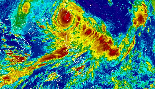
MANILA, Philippines – Typhoon Hanna (Haikui) made landfall in Taitung County, Taiwan, on Sunday afternoon, September 3, while still affecting extreme Northern Luzon and enhancing the southwest monsoon or habagat in the Philippines.
As of 4 pm on Sunday, Hanna was located 245 kilometers north northwest of Itbayat, Batanes. The typhoon accelerated, moving west northwest at 20 kilometers per hour from only 10 km/h.
It still has maximum sustained winds of 155 km/h, but its gustiness jumped to 255 km/h from the previous 190 km/h.
The Philippine Atmospheric, Geophysical, and Astronomical Services Administration (PAGASA) said “strong to typhoon-force winds extend outwards up to 560 kilometers” from Hanna’s center.
Batanes and Babuyan Islands remain under Signal No. 1 as of 5 pm on Sunday, due to strong winds from the typhoon.
Batanes and the northern part of Babuyan Islands also have moderate to heavy rain brought by Hanna.
PAGASA said Hanna will maintain its west northwest direction “while crossing the rugged terrain of southern Taiwan, resulting in considerable weakening.” Taiwan is within the Philippine Area of Responsibility (PAR).
Then the typhoon could emerge over the Taiwan Strait and leave PAR late Sunday evening or early Monday morning, September 4.
Outside PAR, it may slow down over the Taiwan Strait, and also weaken further.
PAGASA said Hanna could make its final landfall along the coast of Guangdong or Fujian in China on Tuesday, September 5, as a severe tropical storm. By late Wednesday, September 6, or Thursday, September 7, it could weaken into a remnant low.

Meanwhile, the enhanced southwest monsoon is still bringing rain to the western part of Luzon as well as the province of Antique. Affected areas must stay on alert for floods and landslides.
Sunday, September 3
- 100-200 millimeters (mm): Ilocos Region, Abra, Benguet, Zambales, Bataan, Occidental Mindoro
- 50-100 mm: Metro Manila, rest of Cordillera Administrative Region, Tarlac, Nueva Ecija, Pampanga, Bulacan, Rizal, Cavite, Batangas, Romblon, northern part of Palawan including Calamian and Cuyo islands, Antique
Monday, September 4
- 100-200 mm: Ilocos Region, Zambales, Bataan
- 50-100 mm: Metro Manila, Abra, Benguet, Tarlac, Nueva Ecija, Pampanga, Bulacan, Rizal, Cavite, Batangas, Occidental Mindoro, northern part of Palawan including Calamian and Cuyo islands, Antique
Tuesday, September 5
- 50-100 mm: Metro Manila, Ilocos Region, Abra, Benguet, Zambales, Bataan, Tarlac, Nueva Ecija, Pampanga, Bulacan, Rizal

Gusty conditions due to the enhanced southwest monsoon also persist in these areas:
Sunday, September 3
- Ilocos Region, Cordillera Administrative Region, Nueva Vizcaya, Zambales, Pampanga, Bataan, Aurora, Bulacan, Metro Manila, Calabarzon, Mimaropa, Bicol, Western Visayas, northern part of Eastern Visayas
Monday, September 4
- Batanes, Babuyan Islands, Ilocos Region, Abra, Benguet, Apayao, Nueva Vizcaya, Zambales, Pampanga, Bataan, Aurora, Bulacan, Metro Manila, Calabarzon, most of Mimaropa, most of Bicol, most of Western Visayas
Tuesday, September 5
- Batanes, Babuyan Islands, Ilocos Region, Zambales, Bataan, Cavite, northern part of Quezon, Lubang Island, Romblon, Kalayaan Islands
ALSO ON RAPPLER
- LIVE UPDATES: FIBA World Cup 2023 – September 3 games
- Chot Reyes says booing, calls for his resignation took toll on players over FIBA World Cup run
- ‘Hanggang t-shirt lang’: Senators in ‘West PH Sea’ shirts during FIBA match vs China slammed
- LOOK: Miss Philippines pageant opens applications to moms, wives
- How to spend your trip in Siargao
For coastal waters, PAGASA released a new gale warning at 5 pm on Sunday, still due to Hanna and the enhanced southwest monsoon. The following seaboards have rough to very rough waters:
- seaboards of extreme Northern Luzon (Batanes, Babuyan Islands) – waves 2.8 to 5 meters high
- western seaboard of Northern Luzon, Central Luzon, and Southern Luzon (Ilocos Norte, Ilocos Sur, La Union, Pangasinan, Zambales, Bataan, Occidental Mindoro including Lubang Island, northern part of Palawan including Calamian and Kalayaan Islands) – waves 2.8 to 4.5 meters high
- southern seaboard of Southern Luzon and western seaboard of Visayas (Oriental Mindoro, Marinduque, Romblon, Antique, Aklan) – waves 2.8 to 4.5 meters high
- eastern seaboard of Northern Luzon (Cagayan, Isabela) – waves 2.8 to 4.5 meters high
The weather bureau advised fishing boats and other small vessels not to sail, and larger vessels to watch out for big waves.
Hanna is the Philippines’ eighth tropical cyclone for 2023.
For the next 6 months, PAGASA estimated that 6 to 9 tropical cyclones may form within or enter PAR:
- September 2023 – 2 or 3
- October 2023 – 2 or 3
- November 2023 – 1 or 2
- December 2023 – 1 or 2
- January 2024 – 0 or 1
- February 2024 – 0 or 1
– Rappler.com
Add a comment
How does this make you feel?


There are no comments yet. Add your comment to start the conversation.