SUMMARY
This is AI generated summarization, which may have errors. For context, always refer to the full article.
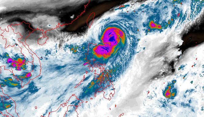
MANILA, Philippines – Signal No. 2 was raised for the province of Batanes on Monday evening, October 2, as Typhoon Jenny (Koinu) continued to intensify.
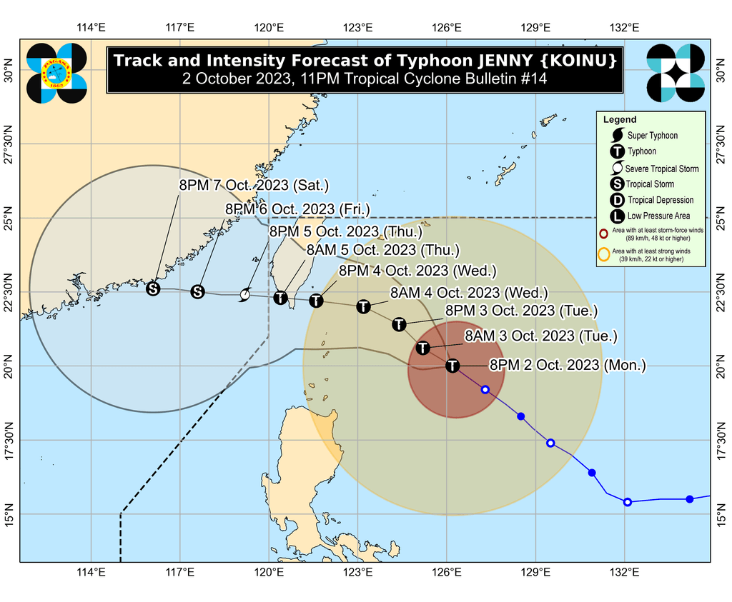
Jenny’s maximum sustained winds increased further from 155 kilometers per hour to 165 km/h, said the Philippine Atmospheric, Geophysical, and Astronomical Services Administration (PAGASA) in a briefing past 11 pm on Monday. The typhoon is “likely at or near its peak intensity” already.
Its gustiness, meanwhile, is now up to 205 km/h from 190 km/h.
Jenny was last spotted 410 kilometers east of Basco, Batanes, moving northwest at a slightly slower 10 km/h from the previous 15 km/h.
The typhoon is not expected to make landfall in the Philippines, but it is affecting Northern Luzon.
The following areas are under tropical cyclone wind signals as of 11 pm on Monday:
Signal No. 2
Gale-force winds (62 to 88 km/h), minor to moderate threat to life and property
- Batanes
Signal No. 1
Strong winds (39 to 61 km/h), minimal to minor threat to life and property
- Cagayan including Babuyan Islands
- northern and eastern parts of Isabela (Maconacon, Divilacan, Palanan, Santa Maria, San Pablo, Tumauini, Cabagan, Ilagan City, San Mariano, Santo Tomas, Dinapigue, Benito Soliven, Naguilian, Gamu, Quirino, Delfin Albano, Quezon, Mallig)
- Apayao
- northeastern part of Abra (Tineg, Lacub, Malibcong)
- northern part of Kalinga (Balbalan, Pinukpuk, Rizal, Tabuk City)
- Ilocos Norte
PAGASA is not ruling out the possibility of raising Signal No. 3.
ALSO ON RAPPLER
- Pork barrel scam queen Napoles gets more years in prison for corruption of public official
- In House of Representatives, Stella Quimbo’s office endures staff turnovers
- Philippines launches tourist call center, welcomes 4 million visitors
- Hungarian, US scientists win Nobel for COVID-19 vaccine discoveries
- MTRCB on ‘It’s Showtime’: Contractualization of workers separate issue from program’s suspension
The weather bureau also updated its rainfall forecast for Jenny, covering the next three days. The rain may trigger floods and landslides.
Monday night, October 2, to Tuesday night, October 3
- 50-100 millimeters (mm): Batanes, Babuyan Islands, northeastern part of mainland Cagayan
Tuesday night, October 3, to Wednesday night, October 4
- 100-200 mm: Batanes
- 50-100 mm: Babuyan Islands, Ilocos Norte, northern part of Apayao, northwestern part of mainland Cagayan
Wednesday night, October 4, to Thursday night, October 5
- 50-100 mm: Batanes
The typhoon is projected to head northwest or west northwest until Wednesday morning, October 4, before turning west.
It could make landfall in the southern part of Taiwan on Thursday morning, October 5, then leave the Philippine Area of Responsibility on Thursday afternoon. Taiwan is within PAR.
PAGASA also said Jenny may start weakening on Tuesday, October 3, as dry air enters its circulation. It will further weaken once it hits Taiwan’s rugged terrain and as it emerges over the Taiwan Strait, where it will again interact with dry air.
In a separate advisory at 11 pm on Monday, PAGASA said Jenny will continue to enhance the southwest monsoon or habagat, which is affecting these areas:
Monday night, October 2, to Tuesday night, October 3
- 50-100 mm: Occidental Mindoro, Palawan, Western Visayas
Tuesday night, October 3, to Wednesday night, October 4
- 50-100 mm: Zambales, Bataan, Occidental Mindoro, northern part of Palawan including Calamian, Cuyo, and Kalayaan Islands, Metro Manila, Pampanga, Bulacan, Cavite, Batangas, Antique
Wednesday night, October 4, to Thursday night, October 5
- 50-100 mm: Zambales, Bataan, Occidental Mindoro, Calamian Islands, Kalayaan Islands
Gusty conditions due to the enhanced southwest monsoon will also be felt in these areas:
Tuesday, October 3
- Aurora, Bataan, Bulacan, Metro Manila, Calabarzon, Bicol, most of Mimaropa, most of Western Visayas
Wednesday, October 4
- Bataan, southern part of Aurora, Metro Manila, Calabarzon, most of Bicol, Romblon
Thursday, October 5
- parts of Calabarzon, parts of Bicol, Romblon
For coastal waters, the gale warning released at 5 pm on Monday remains in effect. Rough to very rough seas will persist in the northern and eastern seaboards of Northern Luzon, specifically Batanes and Cagayan including Babuyan Islands. Travel is risky for small vessels as waves are 2.8 to 5 meters high.
The typhoon is also causing moderate to rough seas in the coastal waters of Isabela, with waves 2 to 4 meters high. The weather bureau advised small vessels to take precautionary measures or avoid sailing, if possible.
Jenny is the Philippines’ 10th tropical cyclone for 2023 and the second for September, having developed last Friday, September 29.
PAGASA expects four to seven tropical cyclones to form within or enter PAR from October 2023 to March 2024. For October alone, there may be two or three tropical cyclones. – Rappler.com
Add a comment
How does this make you feel?


There are no comments yet. Add your comment to start the conversation.