SUMMARY
This is AI generated summarization, which may have errors. For context, always refer to the full article.
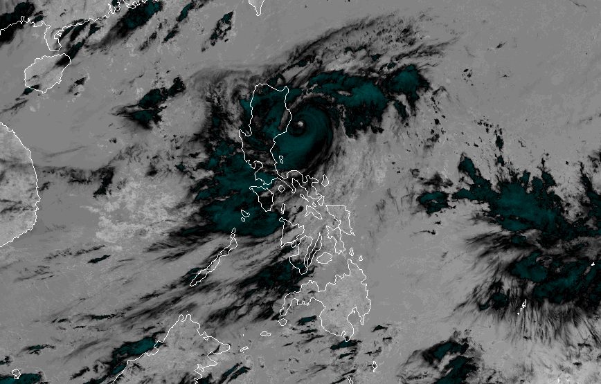
MANILA, Philippines – Super Typhoon Goring (Saola) maintained its strength on Sunday morning, August 27, while continuing to enhance the southwest monsoon or habagat.
At 10 am on Sunday, Goring was already 95 kilometers east northeast of Casiguran, Aurora, moving south southwest at only 10 kilometers per hour (km/h).
The super typhoon still has maximum sustained winds of 185 km/h and gustiness of up to 230 km/h, said the Philippine Atmospheric, Geophysical, and Astronomical Services Administration (PAGASA) in a noontime briefing.
While Goring is expected to stay offshore, it is still bringing torrential rain and severe winds.
ALSO ON RAPPLER
- EJ Obiena matches own Asian record, vaults to historic silver in World Athletics Championships
- Thanks to PBA cousin Chris, Paolo Banchero all set for World Cup stint in Manila
- From small-town boy to crowd darling: USA’s Austin Reaves feels ‘special’ in Manila
- LOOK: Lovi Poe and Monty Blencowe are married
PAGASA maintained its rainfall forecast for Goring, and reiterated that affected areas must be on alert for floods and landslides.
Sunday noon, August 27, to Monday noon, August 28
- Greater than 200 millimeters (mm): extreme eastern part of Isabela
- 100-200 mm: eastern part of mainland Cagayan, eastern part of Isabela
- 50-100 mm: Ilocos Region, Apayao, Abra, Benguet, northern part of Aurora, eastern part of Nueva Vizcaya, rest of mainland Cagayan, rest of Isabela
Monday noon, August 28, to Tuesday noon, August 29
- 50-100 mm: eastern part of Babuyan Islands, mainland Cagayan
Tuesday noon, August 29, to Wednesday noon, August 30
- 100-200 mm: Batanes, eastern part of Babuyan Islands
- 50-100 mm: rest of Babuyan Islands, northern part of mainland Cagayan
Meanwhile, the list of areas under tropical cyclone wind signals has been updated as of 11 am on Sunday. Below is the full list.
Signal No. 3
Storm-force winds (89 to 117 km/h), moderate to significant threat to life and property
- eastern part of Isabela (Divilacan, Palanan, Dinapigue, Ilagan City, San Mariano)
Signal No. 2
Gale-force winds (62 to 88 km/h), minor to moderate threat to life and property
- eastern part of mainland Cagayan (Peñablanca, Baggao, Gattaran, Lal-lo, Gonzaga, Santa Teresita, Buguey, Santa Ana, Enrile, Tuguegarao City)
- northern and central parts of Isabela (Maconacon, Cabagan, Tumauini, San Pablo, Benito Soliven, San Guillermo, Jones, Echague, San Agustin, Angadanan, Cauayan City, Naguilian, Gamu, Santa Maria, Santo Tomas, Delfin Albano, Quirino, Burgos, Reina Mercedes, Alicia, Luna, Quezon, Mallig, Roxas, San Manuel, Aurora, Cabatuan, San Mateo, San Isidro)
- extreme northern part of Aurora (Casiguran, Dinalungan, Dilasag)
- eastern part of Quirino (Maddela)
Signal No. 1
Strong winds (39 to 61 km/h), minimal to minor threat to life and property
- Batanes
- rest of Cagayan including Babuyan Islands
- rest of Aurora
- rest of Quirino
- rest of Isabela
- Apayao
- Nueva Vizcaya
- Ifugao
- Mountain Province
- Kalinga
- Abra
- eastern part of Ilocos Norte (Pagudpud, Adams, Vintar, Carasi, Nueva Era, Banna, Marcos, Dingras, Solsona, Piddig, Dumalneg, Bangui)
- Polillo Islands
- eastern part of Benguet (Bokod, Buguias, Kabayan, Mankayan)
- eastern part of Nueva Ecija (Carranglan, Pantabangan, Bongabon, Gabaldon, Laur, Rizal)
- Calaguas Islands
For coastal waters, the gale warning issued at 5 am on Sunday remains in effect, covering the following seaboards:
- eastern seaboard of Northern Luzon (Isabela, eastern coast of Cagayan) – rough to high seas, with waves 3.1 to 6.5 meters high
- northern seaboard of Northern Luzon and eastern seaboard of Central Luzon (Batanes, Calayan, Babuyan, northern coast of Cagayan, northern coast of Ilocos Norte, Aurora) – rough to very rough seas, with waves 2.8 to 5 meters high
- eastern seaboard of Southern Luzon (northern coast of Quezon including Polillo Islands) – rough to very rough seas, with waves 2.8 to 4.5 meters high
The weather bureau advised fishing boats and other small vessels not to sail, and larger vessels to watch out for big waves.
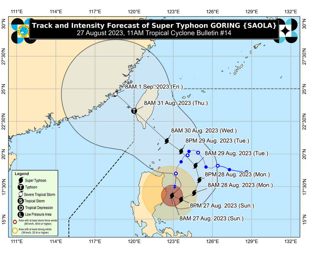
Goring is projected to “begin its loop over the Philippine Sea” east of the Cagayan-Isabela area on Sunday, according to PAGASA.
Then the super typhoon may turn northeast and north on Monday, August 28, before shifting northwest on Tuesday, August 29.
By Wednesday evening, August 30, or early Thursday morning, August 31, it could make landfall in the southern part of Taiwan.
Taiwan is within the Philippine Area of Responsibility (PAR).
The weather bureau added that Goring is expected to maintain its super typhoon status until it makes landfall in Taiwan.
But “land interaction with Taiwan’s rugged terrain will weaken the super typhoon,” PAGASA said. Goring is likely to emerge over the Taiwan Strait and leave PAR on Thursday as a severe tropical storm or a typhoon at its “lowest limit.”
Aside from Goring, the enhanced southwest monsoon is causing rain. Floods and landslides are also possible in affected provinces.
Sunday, August 27
- 100-200 mm: Zambales, Bataan, Occidental Mindoro
- 50-100 mm: Cavite, Batangas, northern part of Palawan including Calamian and Cuyo islands, Antique
Monday, August 28
- 100-200 mm: Zambales, Bataan, Occidental Mindoro
- 50-100 mm: Cavite, Batangas, northern part of Palawan including Calamian and Cuyo islands, Antique, Negros Occidental, southwestern part of Iloilo, northwestern part of Aklan
Tuesday, August 29
- 100-200 mm: Zambales, Bataan, Occidental Mindoro
- 50-100 mm: Cavite, Batangas, Romblon, northern part of Palawan including Calamian and Cuyo islands, Antique, Guimaras, northwestern part of Aklan
The enhanced southwest monsoon is triggering gusty conditions in these areas as well:
Sunday, August 27
- Aurora, Bataan, Metro Manila, Calabarzon, Mimaropa, Bicol, Visayas, Dinagat Islands, Camiguin
Monday, August 28
- Aurora, Bataan, Metro Manila, Calabarzon, Mimaropa, Bicol, Visayas, Dinagat Islands, Camiguin, most of Zamboanga Peninsula
Tuesday, August 29
- Aurora, Bataan, Bulacan, Metro Manila, Calabarzon, Mimaropa, Bicol, Visayas, Dinagat Islands, Camiguin, most of Zamboanga Peninsula
Goring is the Philippines’ seventh tropical cyclone for 2023 and the first for August. It is also the third super typhoon for the year, after Betty (Mawar) in May and Egay (Doksuri) in July.
PAGASA previously said it expects two or three tropical cyclones to develop within or enter PAR in August.
A low pressure area (LPA) also remains outside PAR, located 2,290 kilometers east of Central Luzon on Sunday morning.
PAGASA Assistant Weather Services Chief Chris Perez said during the noontime briefing that the LPA has a chance of developing into a tropical cyclone within 24 to 48 hours. – Rappler.com
Add a comment
How does this make you feel?


There are no comments yet. Add your comment to start the conversation.