SUMMARY
This is AI generated summarization, which may have errors. For context, always refer to the full article.
DAVAO ORIENTAL, Philippines – The Philippine Institute of Volcanology and Seismology (Phivolcs) called for more disaster preparedness in the Davao region and elsewhere in Mindanao following the series of earthquakes that were felt in the Southern Philippines, and in light of the devastating one that hit Turkey and Syria this week.
Phivolcs experts advised it would be best to always be prepared for the “Big One” given the recent seismic activities felt in the country’s second-largest island.
Officials said a high-magnitude earthquake such as the one that devastated Turkey and Syria this week was a possibility anywhere.
The recent earthquake killed more than 5,000 people and caused widespread damage, including the toppling of apartment blocks and hospitals.
Initial reports said some 13.5 million people were affected in an area spanning roughly 450 kilometers from Adana to Diyarbakir, and 300 kilometers from Malatya to Hatay, near the Syrian border, in Turkey alone.
“Every day should be treated as an earthquake preparedness day,” Eduardo Lauron, a senior research specialist of Phivolcs in the Davao region, told Rappler on Tuesday, February 7.
Mindanao is located in a seismically active region and is traversed by several major fault lines, including the Cotabato Trench, the Davao Trench, the Surigao Trench, and the Sulu Trench, which are known to cause earthquakes. The fault lines, where the Earth’s plates are moving, are earthquake generators.
Phivolcs said Davao de Oro, the worst-hit province during the magnitude 6 earthquake on February 1, is one of the most seismically active areas in the country because of active faults in “East Compostela Valley, West Compostela Valley, Central Compostela Valley, Nabunturan, Caraga River, and Mati segments of the Philippine Fault and the Central Mindanao Fault.”
Other nearby local faults could be sources of small to strong magnitude earthquakes, according to Phivolcs.
The worst that could happen is a double whammy because a strong earthquake that occurs beneath an ocean floor can trigger a tsunami.
Jeffrey Perez, a supervising science research specialist at Phivolcs, said the February 1 earthquake would not have resulted in a tsunami because its epicenter was inland.
Perez told a presser on Tuesday that tsunamis are typically caused by earthquakes originating from active trenches and offshore faults with significant vertical movements, or those caused by earthquake-induced landslides near water bodies.
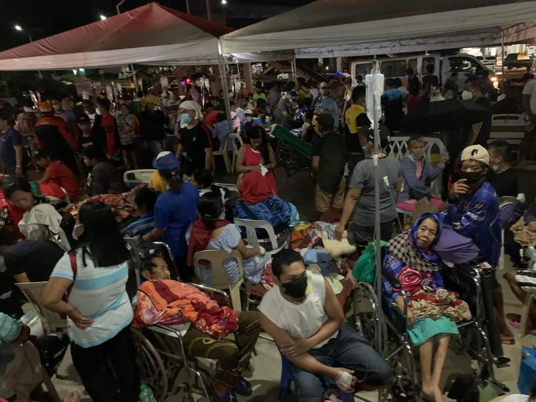
The epicenter of the earthquake in Mindanao, which struck at 6:44 pm on February 1, was located two kilometers southwest of Compostela town in Davao de Oro and had an estimated depth of 17 kilometers. Its effects were felt across several Mindanao regions.
The provincial government of Davao de Oro reported that the damage to vital infrastructure, including the provincial hospital in Montevista, has reached more than P79 million as of Tuesday.
Phivolcs noted that Davao de Oro alone has had nine of the most destructive earthquakes, ranging from magnitudes 6 to 8.3, to hit the region since the late 19th century, and another “strong to great” one could strike again anywhere in Mindanao given its fault lines.
The most damaging earthquake to hit Davao de Oro – a province once called Compostela Valley – took place on June 21, 1893. Known as the magnitude 8.3 Monkayo Earthquake, it caused numerous landslides, liquefaction impacts, and structural damage, and was felt with a maximum intensity of 7 based on the present-day Phivolcs earthquake intensity scale (PEIS).
A PEIS 7 is “very strong” and destructive based on PHIVOLCS’ intensity scale. In a situation like that, frightened people would be running outdoors, heavy objects and furniture would move, wall plasters would crack, old or poorly built houses and structures would be damaged at the very least, and rockfalls and rolling boulders would occur in hilly to mountainous areas.
The most destructive earthquakes are those that have high magnitudes, are shallow, and hit densely populated areas.
The extent of damage depends on factors such as magnitude, depth, distance from the epicenter, local geological conditions, and the type and quality of construction in the affected area.
For instance, a magnitude 7 earthquake that occurs in a crowded city can cause more damage and loss of life than a magnitude 8 that hits a remote area.
The Phivolcs specialists emphasized the importance of being prepared for the “Big One,” pointing out that there was no technology yet that can tell when and where an earthquake may hit.
But researchers said that when an area experiences frequent earthquakes, it could mean that it is located near a tectonic plate boundary where the plates are moving and causing frequent seismic activity. This could also indicate that the place is at high risk for more severe earthquakes.
Lauron, however, said much of the newer infrastructure today has been designed by structural engineers proficient in computing ground motion. These engineers, he said, are capable of building structures that can withstand ground shaking up to a magnitude 8 earthquake.
Phivolcs also advised that people should exercise caution around structures that have been visibly damaged or weakened by earthquakes as these pose risks of crumbling in case of future earthquakes.
It urged local engineering offices to immediately inspect and assess the integrity of the structures.
Phivolcs said structures that are structurally compromised should no longer be occupied.
The experts also urged local governments to inspect slopes for any signs of tension cracks or incipient cracks that may have been caused by strong ground shaking.
Tension cracks, they said, can increase the risk of landslides, especially during heavy rainfall or aftershocks. Phivolcs said these areas should be avoided because they are vulnerable to landslides.
“In case of another strongly felt earthquake, it is recommended that people protect themselves by doing the drop, cover, and hold (technique). In homes and offices, heavy furniture and appliances should be strapped to the walls, and hanging objects securely fastened to prevent these from causing injuries,” Phivolcs advised.
Phivolcs operates a network of 116 seismic stations nationwide, including several located near Davao de Oro. The closest stations to Davao de Oro are the seismic stations in Davao City, Bislig City, and Kidapawan City, as well as satellite-telemetered seismic stations in Davao de Oro, Davao Oriental, Agusan del Sur, Bukidnon, and Mati City. – Rappler.com
Ferdinand Zuasola is an Aries Rufo Journalism fellow.
Add a comment
How does this make you feel?


There are no comments yet. Add your comment to start the conversation.