SUMMARY
This is AI generated summarization, which may have errors. For context, always refer to the full article.
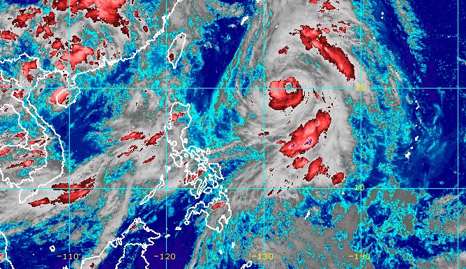
MANILA, Philippines – Severe Tropical Storm Falcon (Khanun) gained more strength on Sunday afternoon, July 30, while the enhanced southwest monsoon or habagat continued to bring rain.
In a bulletin issued at 5 pm on Sunday, the Philippine Atmospheric, Geophysical, and Astronomical Services Administration (PAGASA) said the severe tropical storm’s maximum sustained winds increased from 95 kilometers per hour to 110 km/h.
Its gustiness is now up to 135 km/h from 115 km/h.
Falcon is expected to intensify into a typhoon between Sunday evening and early Monday morning, July 31. Then it could reach its peak intensity on Tuesday, August 1.
As of Sunday afternoon, the severe tropical storm was already 1,170 kilometers east of Northern Luzon, moving north at a faster 20 km/h from its previous speed of 15 km/h.
Based on its current pace, Falcon could leave the Philippine Area of Responsibility (PAR) on Monday evening or early Tuesday morning.

While Falcon has stayed far from land, its trough or extension has been causing rain in a few areas on the eastern side of the Philippines. For the rest of Sunday, Bicol and Northern Samar will still have scattered rain showers and thunderstorms from Falcon’s trough.
The severe tropical storm also continues to enhance the southwest monsoon, which is still affecting Luzon and the Visayas.
Monsoon rain or frequent, heavy rain will persist in Zambales and Bataan, while occasional rain will hit Metro Manila, Pangasinan, Tarlac, Pampanga, Bulacan, Cavite, Batangas, Occidental Mindoro, and the northern part of Palawan including Calamian and Cuyo islands.
The rest of Luzon and the rest of the Visayas will have scattered rain showers and thunderstorms.
PAGASA warned that floods and landslides remain possible.
Meanwhile, tropical cyclone wind signals are unlikely to be raised due to Falcon. But gusty conditions due to the enhanced southwest monsoon will persist in the following areas:
Sunday, July 30
- Zambales, Bataan, Pampanga, Bulacan, Metro Manila, Occidental Mindoro, Palawan, Romblon, most of Calabarzon, most of Bicol, Northern Samar, most of Western Visayas
Monday, July 31
- Ilocos Norte, Pangasinan, Zambales, Bataan, Pampanga, Bulacan, Metro Manila, Occidental Mindoro,
Palawan, Romblon, most of Calabarzon, most of Bicol, Northern Samar, most of Western Visayas
Tuesday, August 1
- Ilocos Region, Abra, Benguet, Zambales, Bataan, Bulacan, Metro Manila, Bicol, most of Calabarzon, most of Mimaropa, most of Western Visayas
In addition, the western seaboard of Luzon still has rough to very rough waters, with waves 2.8 to 4.5 meters high, due to the enhanced southwest monsoon.
PAGASA said in its gale warning at 5 pm on Sunday that affected coastal waters include those of Zambales, Bataan, Pangasinan, Metro Manila, Cavite, the western coast of Batangas, Occidental Mindoro including Lubang Island, and the northern coast of Palawan including Calamian, Cuyo, and Kalayaan islands.
The weather bureau advised small vessels not to sail and larger vessels to watch out for big waves.
Once outside PAR, Falcon may turn west northwest, pass close to Japan’s Okinawa Islands on Tuesday morning, then enter the East China Sea.
Falcon is the Philippines’ sixth tropical cyclone for 2023 and the third for July, coming right after Egay (Doksuri), which pummeled Northern Luzon as a typhoon. Two to four tropical cyclones had been expected for the month. – Rappler.com
Add a comment
How does this make you feel?


There are no comments yet. Add your comment to start the conversation.