SUMMARY
This is AI generated summarization, which may have errors. For context, always refer to the full article.
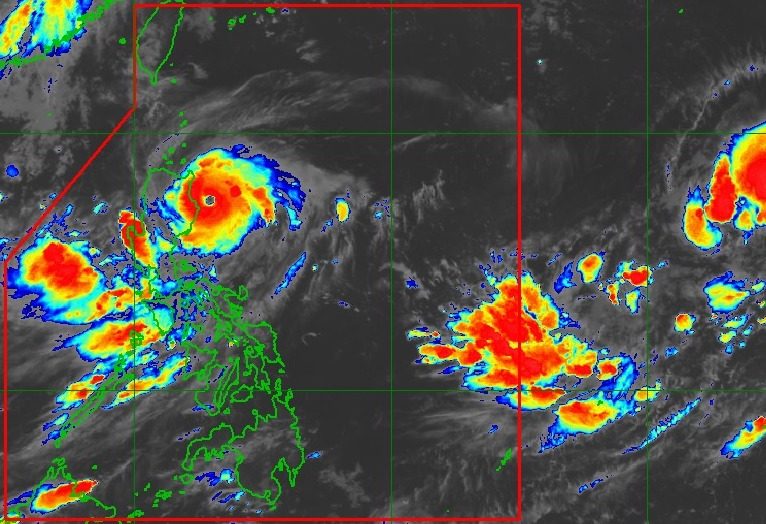
MANILA, Philippines – Typhoon Goring (Saola) continued to further intensify on Saturday evening, August 26, already nearing super typhoon category.
Goring’s maximum sustained winds increased from 155 kilometers per hour to 175 km/h, said the Philippine Atmospheric, Geophysical, and Astronomical Services Administration (PAGASA) in its 11 pm bulletin on Saturday.
The typhoon’s gustiness is now up to 215 km/h from the previous 190 km/h.
It is now expected to become a super typhoon within the next 12 hours, or by Sunday morning, August 27, and achieve its peak intensity on Monday, August 28, or Tuesday, August 29.
A super typhoon has maximum sustained winds of 185 km/h or above.
As of Saturday evening, Goring was located 135 kilometers east southeast of Tuguegarao City, Cagayan. It is still moving south at only 10 km/h.
PAGASA warned that the typhoon may continue moving closer toward the coast of Isabela in the next 6 hours.
ALSO ON RAPPLER
- World Cup veteran Fajardo stays unassuming after Towns matchup: ‘I don’t measure myself one-on-one’
- Chot rues missed chance of giving efficient June Mar more scoring opportunities in loss to Dominicans
- Chot Reyes explains as CJ Perez sits out loss vs Dominican Republic
- [WATCH] Rappler Live Jam: Kyla x Jay R
Goring will continue to dump rain, which may cause floods and landslides in affected areas. Here is PAGASA’s updated rainfall forecast, covering the next three days:
Saturday evening, August 26, to Sunday evening, August 27
- Greater than 200 millimeters (mm): extreme eastern part of Isabela
- 100-200 mm: eastern part of mainland Cagayan, eastern part of Isabela
- 50-100 mm: Ilocos Region, Benguet, Abra, northern part of Aurora, rest of mainland Cagayan, rest of Isabela
Sunday evening, August 27, to Monday evening, August 28
- 50-100 mm: eastern part of Babuyan Islands, mainland Cagayan
Monday evening, August 28, to Tuesday evening, August 29
- 50-100 mm: Batanes, Babuyan Islands, northern part of mainland Cagayan
The weather bureau also updated the list of areas under tropical cyclone wind signals as of 11 pm on Saturday:
Signal No. 3
Storm-force winds (89 to 117 km/h), moderate to significant threat to life and property
- extreme eastern part of Isabela (Divilacan, Palanan)
Signal No. 2
Gale-force winds (62 to 88 km/h), minor to moderate threat to life and property
- eastern part of mainland Cagayan (Peñablanca, Baggao, Gattaran, Lal-lo, Gonzaga, Santa Teresita, Buguey, Santa Ana)
- eastern part of Isabela (Dinapigue, Ilagan City, Maconacon, Cabagan, Tumauini, San Pablo, Benito Soliven, San Mariano)
- extreme northern part of Aurora (Dilasag, Casiguran)
Signal No. 1
Strong winds (39 to 61 km/h), minimal to minor threat to life and property
- Batanes
- Babuyan Islands
- rest of mainland Cagayan
- rest of Isabela
- Quirino
- Nueva Vizcaya
- Apayao
- Kalinga
- Abra
- Mountain Province
- Ifugao
- eastern part of Benguet (Bokod, Buguias, Kabayan, Mankayan)
- eastern part of Ilocos Norte (Pagudpud, Adams, Vintar, Carasi, Nueva Era, Banna, Marcos, Dingras, Solsona, Piddig, Dumalneg, Bangui)
- northeastern part of Nueva Ecija (Carranglan, Pantabangan, Bongabon, Gabaldon, Laur, Rizal)
- northern and central parts of Aurora (Dinalungan, Dipaculao, Baler, Maria Aurora, San Luis)
- Polillo Islands
- Calaguas Islands
PAGASA said it is not ruling out the possibility of raising Signal No. 4 if Goring continues to move slightly closer toward the extreme eastern part of Isabela.
Meanwhile, the gale warning issued at 5 pm on Saturday remains in effect. Rough to very rough seas are seen in these seaboards:
- northern and eastern seaboards of Northern Luzon as well as eastern seaboard of Central Luzon (Batanes, northern coast of Ilocos Norte, Cagayan including Babuyan Islands, Isabela, Aurora) – waves 2.8 to 5 meters high
- eastern seaboard of Southern Luzon (northern coast of Quezon including Polillo Islands) – waves 2.8 to 4.5 meters high
PAGASA advised fishing boats and other small vessels not to sail, and larger vessels to watch out for big waves.
The weather bureau sees Goring turning southeast and east on Sunday, before turning northeast on Monday.
Then on Tuesday, it will start moving northwest, “bringing its center less than 200 kilometers from Batanes” by Wednesday afternoon or evening, August 30.
Goring is also now seen to make landfall in the southeastern coast of Taiwan on Thursday, August 31. Taiwan is within the Philippine Area of Responsibility (PAR).
Its landfall in Taiwan will result in “significant” weakening, but it will remain a typhoon “by the time it emerges over the Taiwan Strait” on Thursday evening or early Friday morning, September 1.

Goring also continues to enhance the southwest monsoon or habagat. Rain from the enhanced southwest monsoon is heaviest in the following provinces:
Sunday, August 27
- 100-200 mm: Occidental Mindoro
- 50-100 mm: Zambales, Bataan, Cavite, Batangas, northern part of Palawan including Calamian and Cuyo islands, Antique
Monday, August 28
- 100-200 mm: Occidental Mindoro
- 50-100 mm: Zambales, Bataan, Cavite, Batangas, Romblon, northern part of Palawan including Calamian and Cuyo islands, Antique, Guimaras, northwestern part of Aklan
The enhanced southwest monsoon is triggering gusty conditions in these areas as well:
Sunday, August 27
- Aurora, Bataan, Metro Manila, Calabarzon, Mimaropa, Bicol, Visayas, Dinagat Islands, Camiguin
Monday, August 28
- Aurora, Bataan, Metro Manila, Calabarzon, Mimaropa, Bicol, Visayas, Dinagat Islands, Camiguin, most of Zamboanga Peninsula
Tuesday, August 29
- Aurora, Bataan, Bulacan, Metro Manila, Calabarzon, Mimaropa, Bicol, Visayas, Dinagat Islands, Camiguin, most of Zamboanga Peninsula
Goring is the Philippines’ seventh tropical cyclone for 2023 and the first for August.
PAGASA previously said it expects two or three tropical cyclones to develop within or enter PAR in August.
A low pressure area (LPA) also remains outside PAR, located 2,210 kilometers east of Central Luzon on Saturday evening.
The LPA has no impact on the country, but it continues to be monitored. – Rappler.com
Add a comment
How does this make you feel?


There are no comments yet. Add your comment to start the conversation.