SUMMARY
This is AI generated summarization, which may have errors. For context, always refer to the full article.
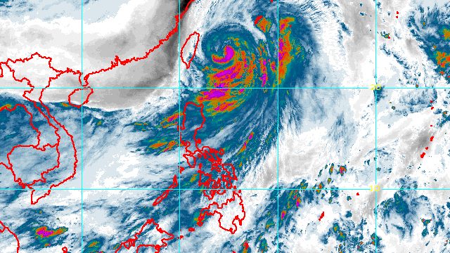
MANILA, Philippines – Typhoon Henry (Hinnamnor) began to accelerate on Saturday morning, September 3, while moving away from the Philippines.
The southwest monsoon or hanging habagat enhanced by the typhoon, however, continued to dump rain in parts of Luzon.
In a bulletin issued at 11 am on Saturday, the Philippine Atmospheric, Geophysical, and Astronomical Services Administration (PAGASA) said Henry was already 405 kilometers northeast of Itbayat, Batanes, moving north at 15 kilometers per hour (km/h).
The typhoon maintained its strength, with maximum sustained winds of 150 km/h and gustiness of up to 185 km/h.
PAGASA said moderate to heavy rain may persist in Batanes and Babuyan Islands due to Henry on Saturday, even as the typhoon moves away. Isolated to scattered floods and landslides remain possible.
Many other areas in Luzon are affected by the enhanced southwest monsoon on Saturday.
In a separate advisory also at 11 am, PAGASA provided the following rainfall forecast for the southwest monsoon:
Moderate to heavy rain, with at times intense rain
- Ilocos Region
- Cordillera Administrative Region
- Zambales
- Bataan
Light to moderate rain, with at times heavy rain
- rest of Central Luzon
- Calabarzon
- Cagayan
- Isabela
- Quirino
- Nueva Vizcaya
Separately, Metro Manila was placed under a yellow rainfall warning as of 11:30 am, with the capital region experiencing heavy rain.
The weather bureau advised affected areas to watch out for scattered floods and landslides.
Meanwhile, tropical cyclone wind signals remain in effect in these areas as of 11 am:
Signal No. 2
Gale-force winds (62 to 88 km/h), minor to moderate threat to life and property
- Batanes
Signal No. 1
Strong winds (39 to 61 km/h), minimal to minor threat to life and property
- Babuyan Islands
- northeastern part of mainland Cagayan (Santa Ana)
PAGASA added that occasional gusts “associated with the enhanced southwest monsoon and its convergence with the typhoon circulation” are likely in the following areas on Saturday:
- Ilocos Region
- Cordillera Administrative Region
- Central Luzon
- Metro Manila
- Calabarzon
- Bicol
- Isabela
- Nueva Vizcaya
- Quirino
- Occidental Mindoro
- Oriental Mindoro
- Romblon
- remaining localities in mainland Cagayan not under Signal No. 1
A new gale warning was issued at 5 am on Saturday, covering these seaboards:
- northern and eastern seaboards of Northern Luzon (Batanes, Cagayan including Babuyan Islands, Isabela, and northern coast of Ilocos Norte) – rough to very rough seas, with waves 2.8 to 5 meters high
- eastern seaboard of Central Luzon (Aurora) and western seaboard of Northern Luzon (western coast of Ilocos Norte) – rough seas, with waves 2.8 to 4 meters high
PAGASA advised small vessels not to sail and large vessels to watch out for big waves.
Moderate to rough seas may also be seen in the eastern seaboard of Southern Luzon on Saturday. Waves could be 1.2 to 3 meters high, making conditions risky for small vessels.
PAGASA said Henry is projected to pass very close to or make landfall in the southern islands of Japan’s Ryukyu archipelago and leave the Philippine Area of Responsibility (PAR) on Saturday evening.
The typhoon may slightly intensify as it leaves PAR, when it is already over the East China Sea.

Henry is the Philippines’ eighth tropical cyclone for 2022. On Thursday, September 1, it absorbed the remnant low that used to be Tropical Depression Gardo, the country’s seventh tropical cyclone for the year.
PAGASA expects 7 to 11 tropical cyclones to enter or develop inside PAR from September 2022 to February 2023. Per month, these are the weather bureau’s estimates:
- September 2022 – 2 or 3
- October 2022 – 2 to 4
- November 2022 – 2 or 3
- December 2022 – 1 or 2
- January 2023 – 0 or 1
- February 2023 – 0 or 1
– Rappler.com
Add a comment
How does this make you feel?


There are no comments yet. Add your comment to start the conversation.