SUMMARY
This is AI generated summarization, which may have errors. For context, always refer to the full article.
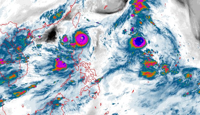
MANILA, Philippines – Signal No. 5, the highest tropical cyclone wind signal, was raised for Babuyan Island late Tuesday evening, August 29, as Goring (Saola) re-intensified from a typhoon into a super typhoon.
Babuyan Island, home to 1,910 people based on the 2020 census, is part of the island group of the same name. It is also under the municipality of Calayan in Cagayan province.
As of 10 pm, Goring was already over the coastal waters of Babuyan Island, prompting the Signal No. 5 declaration. The super typhoon is moving northwest at only 10 kilometers per hour (km/h).
“Violent, life-threatening conditions now prevail over portions of Babuyan Islands,” warned the Philippine Atmospheric, Geophysical, and Astronomical Services Administration (PAGASA) in a bulletin issued past 11 pm on Tuesday, referring as well to other parts of the island group.
Goring’s maximum sustained winds increased from 175 km/h earlier in the evening to 185 km/h at present – also its previous peak. Its gustiness is now up to 230 km/h from 205 km/h.
Based on PAGASA’s latest forecast, the super typhoon could pass very close to or make landfall in the vicinity of Babuyan Island or in the Batan-Sabtang islands area of Batanes between Tuesday night and Wednesday afternoon, August 30.
The weather bureau noted: “Regardless of landfall or close approach point, Goring will bring typhoon-force conditions over most of Batanes and Babuyan Islands between [Tuesday night] and [Wednesday] afternoon. The super typhoon will be passing through the region at or near its peak intensity.”

Below is the full list of areas under tropical cyclone wind signals as of 11 pm on Tuesday.
Signal No. 5
Typhoon-force winds (185 km/h or higher), extreme threat to life and property
- northeastern part of Babuyan Islands (Babuyan Island)
Signal No. 4
Typhoon-force winds (118 to 184 km/h), significant to severe threat to life and property
- southern part of Batanes (Sabtang, Uyugan, Ivana, Mahatao, Basco)
- northwestern and southeastern parts of Babuyan Islands (Camiguin Island, Calayan Island)
Signal No. 3
Storm-force winds (89 to 117 km/h), moderate to significant threat to life and property
- rest of Batanes
- rest of Babuyan Islands
- extreme northeastern part of mainland Cagayan (Santa Ana)
Signal No. 2
Gale-force winds (62 to 88 km/h), minor to moderate threat to life and property
- northern and eastern parts of mainland Cagayan (Gonzaga, Santa Praxedes, Claveria, Sanchez Mira, Pamplona, Abulug, Ballesteros, Aparri, Buguey, Camalaniugan, Santa Teresita, Allacapan, Lal-lo, Lasam, Gattaran, Baggao, Peñablanca)
- northern part of Ilocos Norte (Pagudpud, Adams, Bangui, Dumalneg)
- northern part of Apayao (Calanasan, Luna, Santa Marcela, Flora, Pudtol)
Signal No. 1
Strong winds (39 to 61 km/h), minimal to minor threat to life and property
- northern and eastern parts of Isabela (Dinapigue, San Mariano, Ilagan City, Tumauini, San Pablo, Cabagan, Maconacon, Divilacan, Palanan, Santa Maria, Santo Tomas, Quezon, Delfin Albano)
- rest of Cagayan
- rest of Ilocos Norte
- rest of Apayao
- northern part of Abra (Tineg, Lagayan, Lacub, Malibcong)
- northern part of Kalinga (Balbalan, Pinukpuk, Rizal, Tabuk City)
PAGASA also warned that Goring will continue to trigger heavy to torrential rain in parts of Northern Luzon until Wednesday evening. Floods and landslides could still occur.
Tuesday evening, August 29, to Wednesday evening, August 30
- Greater than 200 mm: Babuyan Islands, Batanes
- 100-200 mm: Ilocos Norte, northern part of Apayao, northwestern part of mainland Cagayan
- 50-100 mm: northeastern part of mainland Cagayan, Ilocos Sur, Abra, rest of Apayao
ALSO ON RAPPLER
- Veteran broadcast journalist Mike Enriquez dies
- Senate detains chief investigator in Jemboy Baltazar’s killing
- Unanswered prayer: Gilas Pilipinas stays winless in FIBA World Cup as Italy advances
- Karl-Anthony Towns dedicates Dominican sweep to late mother, countrymen
Goring is still enhancing the southwest monsoon or habagat, too. The weather bureau updated its rainfall forecast for the enhanced southwest monsoon:
Tuesday evening, August 29, to Wednesday evening, August 30
- 100-200 mm: northern part of Palawan including Calamian and Cuyo islands, Occidental Mindoro
- 50-100 mm: southern part of Palawan including Cagayancillo, Zambales, Bataan, Antique, Negros Occidental, Guimaras
Wednesday evening, August 30, to Thursday evening, August 31
- 100-200 mm: Occidental Mindoro
- 50-100 mm: Zambales, Bataan, Metro Manila, Bulacan, Cavite, Batangas, northern part of Palawan including Calamian and Cuyo islands
Thursday evening, August 31, to Friday evening, September 1
- 100-200 mm: Zambales, Bataan, Occidental Mindoro
- 50-100 mm: Metro Manila, Rizal, Bulacan, Cavite, Batangas, Pangasinan, northern part of Palawan including Calamian and Cuyo islands
The enhanced southwest monsoon is triggering gusty conditions in these areas as well:
Wednesday, August 30
- Ilocos Region, Cordillera Administrative Region, Zambales, Bataan, Bulacan, Aurora, Metro Manila, Calabarzon, Mimaropa, Bicol, Western Visayas
Thursday, August 31, and Friday, September 1
- Ilocos Region, Cordillera Administrative Region, Zambales, Bataan, Bulacan, Pampanga, Aurora, Metro Manila, Calabarzon, Mimaropa, Bicol, Western Visayas

For coastal waters, the gale warning issued at 5 pm on Tuesday – due to both Goring and the enhanced southwest monsoon – remains in effect:
- northern seaboard of Northern Luzon (Batanes, northern coast of Cagayan including Babuyan Islands) – rough to high seas, with waves 3.1 to 6.5 meters high
- seaboards of Northern Luzon (Ilocos Norte, Ilocos Sur, eastern coast of Cagayan, Isabela) – rough to very rough seas, with waves 2.8 to 5 meters high
- western seaboards of Luzon (Zambales, Bataan, Occidental Mindoro, Palawan, La Union, Pangasinan) – rough to very rough seas, with waves 2.8 to 4.5 meters high
- eastern seaboard of Central Luzon, western and southern seaboards of Southern Luzon, western seaboard of Visayas (Aurora, Metro Manila, Cavite, Batangas, Oriental Mindoro, Marinduque, Romblon, Aklan, Antique, Capiz, Iloilo, Guimaras, Negros Occidental) – rough to very rough seas, with waves 2.8 to 4.5 meters high
- seaboards of Quezon and Bicol, central and eastern seaboards of Visayas, northern seaboard of Mindanao (northern Quezon, southern Quezon, Camarines Norte, Camarines Sur, Catanduanes, Albay, Sorsogon, Masbate, Negros Oriental, Cebu, Bohol, Siquijor, Northern Samar, Eastern Samar, Samar, Biliran, Leyte, Southern Leyte, Camiguin, Dinagat Islands, western coast of Surigao del Norte) – rough to very rough seas, with waves 2.8 to 4.5 meters high
The weather bureau advised fishing boats and other small vessels not to sail, and larger vessels to watch out for big waves.
Goring is projected to leave the Philippine Area of Responsibility (PAR) on Wednesday evening or Thursday morning, August 31.
Outside PAR, it may move “nearly parallel to the coast of Guangdong, China,” but PAGASA said landfall is possible in mainland China on Sunday, September 3.
“Increasingly unfavorable conditions over the waters off Guangdong will trigger a weakening trend and by Sunday, it will have weakened to minimal typhoon strength,” added the weather bureau.
Goring is the Philippines’ seventh tropical cyclone for 2023 and the first for August. It is also the third super typhoon for the year, after Betty (Mawar) in May and Egay (Doksuri) in July.
PAGASA previously said it expects two or three tropical cyclones to develop within or enter PAR in August.
The second tropical cyclone for August could enter PAR on Wednesday morning – Severe Tropical Storm Haikui, to be locally named Hanna.
Haikui strengthened further on Tuesday evening as it continued to approach PAR, with its maximum sustained winds increasing from 95 km/h to 110 km/h. Its gustiness is now up to 135 km/h from the previous 115 km/h.
The severe tropical storm was last spotted 1,580 kilometers east of extreme Northern Luzon, still moving west northwest at 15 km/h.
Haikui is seen to remain far from Philippine landmass, which means it is “less likely to directly affect the country.”

But Haikui or the potential Hanna will keep intensifying. It may become a typhoon by Wednesday morning, then reach its peak intensity on Friday evening, September 1.
Starting Wednesday or Thursday, it could enhance the southwest monsoon, which may lead to more monsoon rain in the western parts of Luzon and the Visayas.
Haikui is expected to exit PAR on Friday morning, while approaching Japan’s Ryukyu Islands. Outside PAR, it may turn northwest or north over the East China Sea. – Rappler.com
Add a comment
How does this make you feel?


There are no comments yet. Add your comment to start the conversation.