SUMMARY
This is AI generated summarization, which may have errors. For context, always refer to the full article.
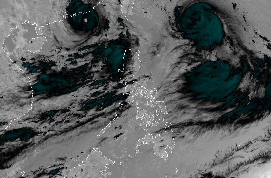
MANILA, Philippines – Hanna (Haikui) intensified from a severe tropical storm into a typhoon on Friday morning, September 1, as its maximum sustained winds increased from 110 kilometers per hour to 120 km/h.
Its gustiness is now up to 150 km/h from the previous 135 km/h.
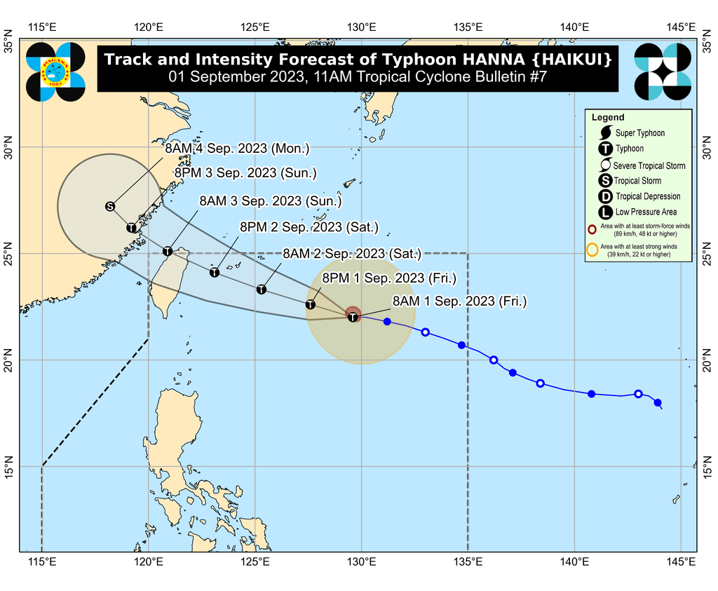
The Philippine Atmospheric, Geophysical, and Astronomical Services Administration (PAGASA) said in its 11 am bulletin on Friday that Hanna was last spotted 785 kilometers east northeast of Itbayat, Batanes.
The typhoon is now moving west, maintaining its speed of 20 km/h.
Hanna will remain far from Philippine landmass, which means it is “less likely” to directly bring rain, winds, or rough sea conditions to the country. But it is helping to enhance the southwest monsoon or habagat.
PAGASA said the typhoon could pass close to or make landfall in Japan’s Yaeyama Islands, part of the Ryukyu archipelago, between Saturday afternoon and evening, September 2. Then it may also make landfall in or pass close to the northern part of Taiwan on Sunday morning, September 3. These places are still within the Philippine Area of Responsibility (PAR).
Hanna may leave PAR also on Sunday morning. Outside PAR, it is expected to cross the Taiwan Strait before making another landfall in mainland China on Sunday afternoon or evening.
In terms of strength, the typhoon could reach its peak intensity on Saturday, before it nears or hits Taiwan. “Rapid weakening will then ensue following its landfall over mainland China on Sunday,” PAGASA said.
Aside from Hanna, two other tropical cyclones – located outside PAR – continue to enhance the southwest monsoon. These are Goring (Saola), which has since weakened from a super typhoon into a typhoon, and Severe Tropical Storm Kirogi.
As of 3 am on Friday, Goring was located 530 kilometers west of Itbayat, Batanes, while Kirogi was 3,370 kilometers east of Central Luzon. Goring left PAR last Wednesday evening, August 30, while Kirogi is heading for the southern part of Japan.
In a separate advisory issued at 11 am on Friday, PAGASA said the enhanced southwest monsoon is bringing moderate to intense rain to these areas:
Friday, September 1
- 100-200 millimeters (mm): Metro Manila, Zambales, Bataan, Occidental Mindoro
- 50-100 mm: Ilocos Region, Abra, Benguet, Tarlac, Nueva Ecija, Pampanga, Bulacan, Rizal, Cavite, Batangas
Saturday, September 2
- 100-200 mm: Metro Manila, Ilocos Region, Zambales, Bataan, Occidental Mindoro
- 50-100 mm: Abra, Benguet, Tarlac, Nueva Ecija, Pampanga, Bulacan, Rizal, Cavite, Batangas
Sunday, September 3
- 100-200 mm: Metro Manila, Ilocos Region, Zambales, Bataan, Occidental Mindoro
- 50-100 mm: Abra, Benguet, Tarlac, Nueva Ecija, Pampanga, Bulacan, Rizal, Cavite, Batangas, northern part of Palawan including Cuyo and Calamian islands, Antique
Affected regions and provinces must stay on alert for floods and landslides.
ALSO ON RAPPLER
- Chot Reyes shoulders blame, admits Gilas Pilipinas stumbled in World Cup home stand
- Kai Sotto empathizes with disappointment of fans, hopes for better Gilas vs China
- USA captain Brunson braces for ‘proven’ 2nd-round foes Lithuania, Montenegro
- Rappler Talk: Migz Zubiri on keeping the Senate independent
- [WATCH] Rappler Live Jam: CESCA
Gusty conditions will also persist in these areas due to the enhanced southwest monsoon:
Friday, September 1
- Batanes, Ilocos Region, Cordillera Administrative Region, Zambales, Bataan, Aurora, Bulacan, Metro Manila, Calabarzon, Mimaropa, Bicol, Western Visayas, northern part of Eastern Visayas
Saturday, September 2
- Batanes, Ilocos Region, Abra, Benguet, Zambales, Bataan, Aurora, Bulacan, Metro Manila, Calabarzon, Mimaropa, Bicol, Western Visayas, northern part of Eastern Visayas
Sunday, September 3
- Batanes, Ilocos Norte, Ilocos Sur, Zambales, Bataan, Aurora, Bulacan, Metro Manila, Calabarzon, Mimaropa, Bicol, Western Visayas

Meanwhile, PAGASA issued a gale warning at 5 am on Friday due to Goring, Hanna, and the southwest monsoon. Rough to very rough seas are expected in the following seaboards:
- northern and western seaboards of Northern Luzon (Batanes, northern coast of Cagayan including Babuyan Islands, Ilocos Norte, Ilocos Sur, La Union, Pangasinan) – waves 3.1 to 5 meters high
- western seaboard of Central Luzon and Southern Luzon (Zambales, Bataan, Metro Manila, Cavite, Batangas, Occidental Mindoro including Lubang Island) – waves 2.8 to 4.5 meters high
- eastern and southern seaboards of Luzon (eastern coast of Cagayan, Isabela, Aurora, northern Quezon, southern Quezon, Camarines Norte, Camarines Sur, Catanduanes, Albay, Sorsogon, Masbate including Ticao and Burias Islands, Oriental Mindoro, Marinduque, Romblon, Palawan) – waves 2.8 to 4.5 meters high
- western and eastern seaboards of Visayas (Antique, Aklan, Capiz, Iloilo, Guimaras, Northern Samar) – waves 2.8 to 4.5 meters high
The weather bureau advised fishing boats and other small vessels not to sail, and larger vessels to watch out for big waves.
Goring and Hanna are the Philippines’ seventh and eighth tropical cyclones for 2023, respectively.
For the next 6 months, PAGASA estimated that 6 to 9 tropical cyclones may form within or enter PAR:
- September 2023 – 2 or 3
- October 2023 – 2 or 3
- November 2023 – 1 or 2
- December 2023 – 1 or 2
- January 2024 – 0 or 1
- February 2024 – 0 or 1
– Rappler.com
Add a comment
How does this make you feel?


There are no comments yet. Add your comment to start the conversation.