SUMMARY
This is AI generated summarization, which may have errors. For context, always refer to the full article.
![[OPINION] Nuclear weapons tests and the dangers of the Runit Dome](https://www.rappler.com/tachyon/2022/05/Screen-Shot-2022-05-30-at-1.55.54-PM.png)
The following is the 33rd in a series of excerpts from Kelvin Rodolfo’s ongoing book project “Tilting at the Monster of Morong: Forays Against the Bataan Nuclear Power Plant and Global Nuclear Energy.“
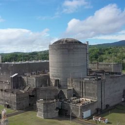
Fractured by the “Cactus” test, the coral underlying the crater on Runit Island was porous to begin with. Three other nearby blasts had crushed it even more. And so the official drawing of the original plan, “exploded” to reveal its details, included a concrete liner of the crater.
But to save costs the liner was not made, and so I have removed it here. To justify the changes, officials then said that the repository would just be a cheap, temporary shelter to be replaced later.
That’ll never happen.

Most of the crater lay below high-tide levels, and so a “keywall” buried eight feet deep and standing eight feet high was built around it as protection against the waves. The keywall is a vertical cylinder 1,200 feet in circumference, made of 99 concrete panels each two feet thick. Its base is encased in large boulders and concrete.
But it rests on fractured coral, not on hard bedrock, and ocean waves, especially when driven by typhoon winds, are some of Nature’s most destructive agencies.
The cleanup troops gathered 73,000 cubic meters of surface soil from Runit and the five other contaminated Enewetak islands, mixed it with Portland cement and pumped it into the crater. Much oversized radioactive and non-radioactive debris, including equipment, concrete, and scrap metal also went into two parts of the crater.
Years before, back in August 1958, the very last two nuclear tests on central Runit had not gone well. The “Quince” test simply blew up, yielding no energy, and scattered many chunks of plutonium around the area. To prepare for “Fig” a few days later, much of this debris was simply bulldozed into the lagoon.
The “Fig” test was little better, yielding no more than a conventional 20-ton TNT explosion. It also strewed fragmented plutonium about.
During the cleanup the troops picked up and filled 437 plastic bags with 700 plutonium fragments. When the cleanup was almost finished and the crater had been filled and mounded up into a domed shape, the bagged plutonium was put into the top of the mound through a “donut hole.”
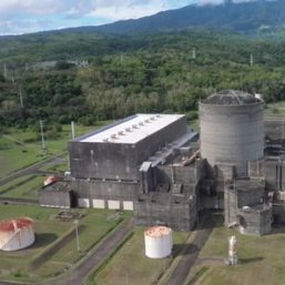
Finally, the crews capped the dome. They made 358 separate concrete panels 18 inches thick on top of it, fitted them together, and added a circular top over the donut hole. In this picture, the offshore crater is from the earlier Lacrosse test.

Even during the cleanup in early January 1979, Tropical Storm Alice had seriously disrupted the effort. Storm waves riding atop a three-foot storm surge badly damaged structures in the atoll and delayed the cleanup for months. This led the federal government’s National Research Council to warn in 1982 that a major typhoon could break the dome open. But nothing was done about this for 20 years.
Finally, in 1992 the US Department of Energy saw no cause for alarm: “Catastrophic failure of the concrete dome and instantaneous release of all its contents into the lagoon will not necessarily lead to any significant change in the radiation dose delivered to the local resident population.” Ironically, that is because the radiation in the lagoon outside the dome is much larger than inside it.
It turns out that the cleanup had gathered less than 1% of the radioactive waste in the atoll. Much more had been simply bulldozed into the lagoon. For this, the US Government had spent about $100 million and kept almost 1,000 troops on the atoll from 1977 to 1980, killing six in accidents and ruining the health of so many others?
Almost immediately after the dome was completed, storm waves dredged up about 90 cubic meters of intensely radioactive debris from the sea floor and left it on Runit beaches. It was collected and stored in a small containment next to the dome. This happened again, necessitating a second external containment.
Nothing has been done to maintain the Runit Dome since it was closed in 1980. The dri Enewetak call it “the Tomb.” From afar it looks like a flying saucer had crashed into Runit. It is by far the tallest thing on the atoll, its 25 feet more than three times taller than anything else. Runit is uninhabited and unguarded. Warning signs periodically appear and disappear, but occasional visitors ignore them.

The dome cap, lying without structural support on radioactive waste that compacts unevenly, is cracking, especially at its base. Weeds growing in the cracks are expanding them. In 2009 a storm surge opened a channel from the reef to the dome, tidings of terrible things to come as the globe warms, the oceans rise, and typhoons worsen.
Unseen under the dome, the entombed radioactive waste sits directly on porous coral. Groundwater soaking the waste rises and falls with the tides, a perpetual pump sucking radioactive seawater out of it. In Marshallese, Runit means “go through the pit,” strangely seeming to anticipate this.
The North Equatorial Current entrains some of the dome water and brings it westward and northward.
The young woman photographed on the dome is Marshallese poet Kathy Jetñil-Kijiner, one of my personal heroes. She eulogized Runit with her poem “Anointed.” An excerpt:
How shall we remember you?
You were a whole island, once. You were breadfruit trees heavy with green globes of fruit whispering promises of massive canoes. Crabs dusted with white sand scuttled through pandanus roots. Beneath looming coconut trees beds of ripe watermelon slept still, swollen with juice. And you were protected by powerful irooji, chiefs birthed from women who could swim pregnant for miles beneath a full moon.
Then you became testing ground. Nine nuclear weapons consumed you, one by one by one, engulfed in an inferno of blazing heat. You became crater, an empty belly. Plutonium ground into a concrete slurry filled your hollow cavern. You became tomb. You became concrete shell…
But listen to her video rendition, for the printed word does not do her full justice.
The nuclear tests left the northern Enewetak islands more radioactive than Chernobyl or Fukushima. For 18 years after the nuclear tests the US military continued to use the atoll to test other weapons, including a series of large conventional bombs.
Worse, germ-warfare bombs and missiles were tested on northern Enewetak Atoll in 1968. They explosively dispersed bacterial antigens such as enhanced staphylococcal enterotoxin B, which kills with severe toxic shock. Each test made a bacteria-laden cloud that covered an area of about 2,400 square kilometers (more than 900 square miles).
The atoll was also used as practice targets for intercontinental ballistic missiles lobbed at it from California.
In 1972, after the US military had little more use for the atoll, it brought the Enewetak leaders on Ujelong Atoll to visit their home atoll for the first time since their ouster in 1946. The leaders were shocked at how badly the testing had trashed their homeland: denuded, devastated, heavily cluttered with abandoned and decaying concrete buildings and rusting equipment.
Our next foray looks at what has happened to the exiles after they returned home, and what the future holds for them and for Enewetak Atoll. – Rappler.com
Born in Manila and educated at UP Diliman and the University of Southern California, Dr. Kelvin Rodolfo taught geology and environmental science at the University of Illinois at Chicago since 1966. He specialized in Philippine natural hazards since the 1980s.
Keep posted on Rappler for the next installment of Rodolfo’s series.
Previous pieces from Tilting at the Monster of Morong:
- [OPINION] Tilting at the Monster of Morong
- [OPINION] Mount Natib and her sisters
- [OPINION] Sear, kill, obliterate: On pyroclastic flows and surges
- [OPINION] Beneath the waters of Subic Bay an old pyroclastic-flow deposit, and many faults
- [OPINION] Propaganda about faulting, earthquakes, and the Bataan Nuclear Power Plant
- [OPINION] Discovering the Lubao Fault
- [OPINION] The Lubao Fault at BNPP, and the volcanic threats there
- [OPINION] How Natib volcano and her 2 sisters came to be
- [OPINION] More BNPP threats: A Manila Trench megathrust earthquake and its tsunamis
- [OPINION] Shoddy, shoddy, shoddy: How they built the Bataan Nuclear Power Plant
- [OPINION] Where, oh where, would BNPP’s fuel come from?
- [OPINION] ‘Megatons to Megawatts’: Prices and true costs of nuclear energy
- [OPINION] Uranium enrichment for energy leads to enrichment for weapons
- [OPINION] Introducing the nuclear fuel cycle
- [OPINION] On uranium mining and milling
- [OPINION] Enriching and fabricating BNPP’s uranium fuel
- [OPINION] Decommissioning BNPP, and storing the nuclear dragon’s radioactive manure
- [OPINION] So how much greenhouse gas does nuclear power really generate?
- [OPINION] Getting up close and personal with the atom, and its nucleus that powers NPPs
- [OPINION] The nucleus and isotopes: Why BNPP needs Uranium 235, Not Uranium 238
- [OPINION] What you should know about radioactivity
- [OPINION] Uranium mine waste and the weird idea of half-life
- [OPINION] How nuclear power plants work: Hot monster piss from Morong
- [OPINION] What if there was a spent-fuel pool accident at the Bataan Nuclear Power Plant?
- [OPINION] Nuclear weaponry, its radiation, and human health
- [OPINION] What Chernobyl could have taught us, but hasn’t been allowed to
- [OPINION] Activating BNPP would give cancer to workers and adults living nearby
- [OPINION] Activate BNPP? You could increase childhood cancers in Bataan and beyond
- [OPINION] The Hanford Site: Where nuclear pollution began and still reigns
- [OPINION] Enewetak, Paradise Lost: Enewetak and its people
- [OPINION] The Cold War’s nuclear weapons tests, and the damage and waste they left behind
Add a comment
How does this make you feel?

![[OPINION] Who decides whether Bataan should go nuclear?](https://www.rappler.com/tachyon/2023/08/imho-bataan-nuclear-powerplant.jpg?resize=257%2C257&crop=271px%2C0px%2C720px%2C720px)
![[OPINION] Nuclear energy should not become major part of Philippine energy system](https://www.rappler.com/tachyon/2023/01/nuclear-energy-january-26-2023.jpg?resize=257%2C257&crop=205px%2C0px%2C900px%2C900px)


There are no comments yet. Add your comment to start the conversation.