SUMMARY
This is AI generated summarization, which may have errors. For context, always refer to the full article.
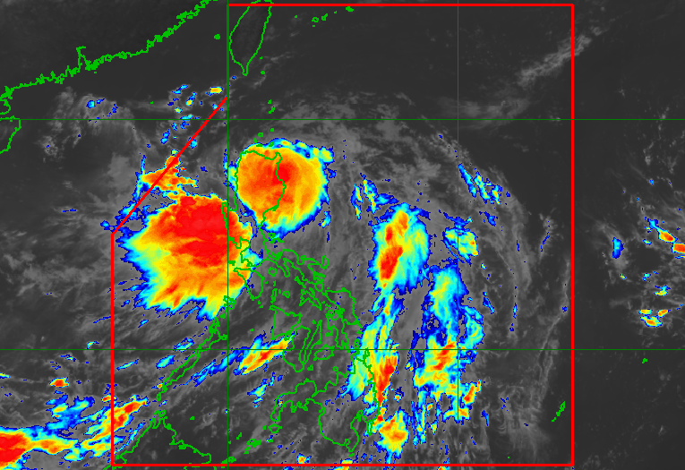
MANILA, Philippines – Severe Tropical Storm Florita (Ma-on) intensified further as it made landfall in Maconacon, Isabela, at 10:30 am on Tuesday, August 23.
Florita’s maximum sustained winds increased from 95 kilometers per hour to 110 km/h, while its gustiness increased from 115 km/h to 150 km/h.
The severe tropical storm maintained its speed, moving northwest at 20 km/h.
In a briefing past 11 am on Tuesday, the Philippine Atmospheric, Geophysical, and Astronomical Services Administration (PAGASA) said Florita is expected to cross the northern part of Isabela and mainland Cagayan for the rest of the day, then emerge over the Babuyan Channel in the evening.
Florita is dumping rain not just in Isabela and Cagayan, but also in other parts of Luzon. Affected areas must stay on alert for floods and landslides during the passage of the severe tropical storm.
Tuesday, August 23
Heavy to intense rain, with at times torrential rain
- Cagayan
- Isabela
- Cordillera Administrative Region
- Ilocos Region
- Zambales
- Bataan
Moderate to heavy rain, with at times intense rain
- rest of Cagayan Valley
- northern part of Aurora
- Tarlac
- Pampanga
- Bulacan
- Metro Manila
- Cavite
- Rizal
Light to moderate rain, with at times heavy rain
- rest of Central Luzon
- rest of Calabarzon
Wednesday, August 24
Moderate to heavy rain, with at times intense rain
- Ilocos Region
- Benguet
- Abra
Light to moderate rain, with at times heavy rain
- rest of Cordillera Administrative Region
- Zambales
- Bataan
Florita also continues to enhance the southwest monsoon or hanging habagat, which is bringing light to heavy rain to Mimaropa and Western Visayas on Tuesday. Floods and landslides are possible in these regions, too.

Here are the areas under tropical cyclone wind signals as of 11 am on Tuesday:
Signal No. 3
Storm-force winds (89 to 117 km/h), moderate to significant threat to life and property
- northern part of Ilocos Norte (Pagudpud, Dumalneg, Adams, Bangui, Burgos)
- Apayao
- southern part of Babuyan Islands (Camiguin Island, Fuga Island, Dalupiri Island)
- mainland Cagayan
- northeastern part of Isabela (Palanan, Divilacan, Maconacon, San Pablo, Tumauini, Cabagan, Santa Maria, Santo Tomas, Delfin Albano, Ilagan City, San Mariano)
Signal No. 2
Gale-force winds (62 to 88 km/h), minor to moderate threat to life and property
- rest of Babuyan Islands
- rest of Isabela
- Quirino
- northern and eastern parts of Nueva Vizcaya (Quezon, Diadi, Bagabag, Villaverde, Solano, Kasibu)
- Abra
- Kalinga
- Mountain Province
- Ifugao
- northern part of Benguet (Buguias, Bakun, Mankayan, Kibungan)
- rest of Ilocos Norte
- Ilocos Sur
- northern part of Aurora (Dilasag, Casiguran, Dinalungan, Dipaculao)
Signal No. 1
Strong winds (39 to 61 km/h), minimal to minor threat to life and property
- Batanes
- rest of Nueva Vizcaya
- rest of Benguet
- La Union
- eastern part of Pangasinan (Santo Tomas, Villasis, Mapandan, Mangaldan, San Fabian, San Jacinto, Manaoag, Urdaneta City, Rosales, Balungao, Umingan, San Quintin, Natividad, San Nicolas, Tayug, Santa Maria, Asingan, San Manuel, Binalonan, Sison, Pozorrubio, Laoac, Dagupan City)
- northeastern part of Tarlac (San Manuel, Anao)
- Nueva Ecija
- rest of Aurora
PAGASA added that gusts may be experienced in the following areas on Tuesday:
- Metro Manila
- Calabarzon
- Bicol
- Zambales
- Bataan
- Occidental Mindoro
- Oriental Mindoro
- Marinduque
- Romblon
- Northern Samar
- Antique
- Aklan

PAGASA also warned of dangerous coastal conditions due to Florita and the southwest monsoon.
- seaboards of Northern Luzon – rough to high seas, with waves 3.5 to 7 meters high
- eastern seaboards of Central Luzon and Southern Luzon – rough to very rough seas, with waves 2.8 to 4.5 meters high
- western seaboards of Central Luzon, Southern Luzon, and Visayas – rough seas, with waves 2.8 to 4 meters high
- remaining seaboards of Southern Luzon and Visayas – moderate to rough seas, with waves 1.2 to 2.8 meters high
The weather bureau said rough to high seas are risky for all vessels, while small vessels should not sail if seas are rough to very rough.
Moderate to rough seas may also be risky for small vessels.
Florita, the country’s sixth tropical cyclone for 2022, is expected to leave the Philippine Area of Responsibility on Wednesday morning, August 24. – Rappler.com
Add a comment
How does this make you feel?


There are no comments yet. Add your comment to start the conversation.