SUMMARY
This is AI generated summarization, which may have errors. For context, always refer to the full article.
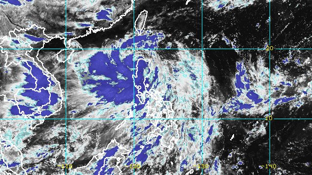
MANILA, Philippines – Severe Tropical Storm Florita (Ma-on) left Philippine landmass on Tuesday evening, August 23, after crossing Isabela, Cagayan, Apayao, and Ilocos Norte.
Florita was already over the coastal waters of Burgos, Ilocos Norte, early Tuesday evening, said the Philippine Atmospheric, Geophysical, and Astronomical Services Administration (PAGASA) in its 8 pm bulletin.
The severe tropical storm slightly accelerated, moving northwest at 25 kilometers per hour from the previous 20 km/h.
Due to Florita’s faster pace, it may leave the Philippine Area of Responsibility (PAR) before dawn on Wednesday, August 24.
The severe tropical storm continued to have maximum sustained winds of 100 km/h and gustiness of up to 165 km/h on Tuesday evening, but it may intensify into a typhoon outside PAR on Wednesday afternoon.
Florita had made landfall in Maconacon, Isabela, at 10:30 am on Tuesday, bringing torrential rain that triggered floods in parts of Luzon. Though the severe tropical storm is already starting to move away from land, rain will continue for the rest of the night and even until Wednesday.
Tuesday, August 23
Moderate to heavy rain, with at times intense rain
- Cordillera Administrative Region
- Ilocos Region
- Zambales
- Tarlac
- Pampanga
- Bataan
Light to moderate rain, with at times heavy rain
- rest of Central Luzon
- Metro Manila
- Cagayan Valley
- Calabarzon
Wednesday, August 24
Moderate to heavy rain
- Ilocos Region
- Benguet
- Abra
- Zambales
- Bataan
Light to moderate rain, with at times heavy rain
- rest of Cordillera Administrative Region
Florita has also been enhancing the southwest monsoon or hanging habagat, which is causing rain in Mimaropa and Western Visayas.

Fewer areas remained under tropical cyclone wind signals as of 8 pm on Tuesday:
Signal No. 3
Storm-force winds (89 to 117 km/h), moderate to significant threat to life and property
- northwestern part of mainland Cagayan (Ballesteros, Pamplona, Abulug, Sanchez-Mira, Claveria, Santa Praxedes)
- southwestern part of Babuyan Islands (Camiguin Island, Dalupiri Island)
- northern and central parts of Apayao (Calanasan, Kabugao, Luna, Pudtol, Flora, Santa Marcela)
- Ilocos Norte
Signal No. 2
Gale-force winds (62 to 88 km/h), minor to moderate threat to life and property
- northern and central parts of Ilocos Sur (Quirino, Gregorio del Pilar, Salcedo, Santa Lucia, Galimuyod, Candon City, San Emilio, Lidlidda, Banayoyo, Santiago, Burgos, San Esteban, Santa Maria, Nagbukel, Narvacan, Santa, Santa Catalina, San Vicente, Bantay, Santo Domingo, San Ildefonso, Caoayan, Vigan City, Magsingal, San Juan, Cabugao, Sinait)
- rest of Apayao
- Kalinga
- Abra
- northern part of Mountain Province (Besao, Sagada, Bontoc, Sadanga, Barlig, Natonin, Paracelis)
- rest of mainland Cagayan
- rest of Babuyan Islands
- northern part of Isabela (Roxas, Quirino, Tumauini, Delfin Albano, Mallig, Quezon, Santo Tomas, Cabagan, Santa Maria, San Pablo, Maconacon)
Signal No. 1
Strong winds (39 to 61 km/h), minimal to minor threat to life and property
- Batanes
- rest of Isabela
- Nueva Vizcaya
- Quirino
- rest of Mountain Province
- Ifugao
- Benguet
- La Union
- rest of Ilocos Sur
- northern and central parts of Aurora (Dipaculao, Dinalungan, Casiguran, Dilasag)
PAGASA also said gusts may persist in these areas:
- Metro Manila
- Calabarzon
- Bicol
- Pangasinan
- Zambales
- Bataan
- Tarlac
- Nueva Ecija
- Pampanga
- Bulacan
- Occidental Mindoro
- Oriental Mindoro
- Marinduque
- Romblon
- remaining areas in Aurora not under wind signals
- Northern Samar
- Antique
- Aklan

Meanwhile, PAGASA’s gale warning issued at 5 pm remains in effect:
- seaboards of Northern Luzon – rough to high seas, with waves 3.5 to 7 meters high
- western seaboard of Northern Luzon as well as eastern and western seaboards of Central Luzon – rough to very rough seas, with waves 2.8 to 4.5 meters high
- seaboards of Southern Luzon and western seaboard of Visayas – rough seas, with waves 2.8 to 4 meters high
- remaining seaboards of Southern Luzon and Visayas – moderate to rough seas, with waves 1.2 to 2.8 meters high
The weather bureau said rough to high seas are risky for all vessels, while small vessels should not sail if seas are rough to very rough.
Moderate to rough seas may also be risky for small vessels.
Florita is the Philippines’ sixth tropical cyclone for 2022. It hit the country during the first week of classes for public schools. – Rappler.com
Add a comment
How does this make you feel?


There are no comments yet. Add your comment to start the conversation.