SUMMARY
This is AI generated summarization, which may have errors. For context, always refer to the full article.
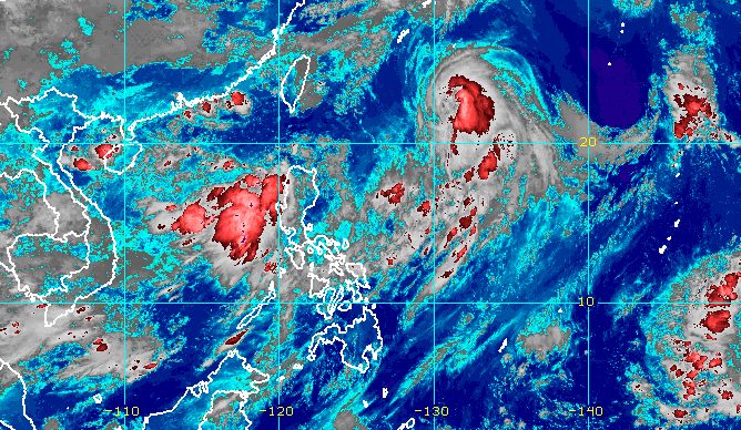
MANILA, Philippines – Typhoon Chedeng (Guchol) continued to weaken while accelerating away from Philippine landmass before dawn on Sunday, June 11, but the enhanced southwest monsoon or habagat is still expected to affect parts of the country.
Chedeng’s maximum sustained winds decreased further from 140 kilometers per hour to 130 km/h, said the Philippine Atmospheric, Geophysical, and Astronomical Services Administration (PAGASA) in its 5 am bulletin on Sunday. The peak was 150 km/h on Saturday, June 10.
The typhoon’s gustiness decreased from 170 km/h to 160 km/h.
PAGASA sees Chedeng getting downgraded to a severe tropical storm on Sunday or early Monday morning, June 12.
As of 4 am on Sunday, the typhoon was already 990 kilometers east of extreme Northern Luzon, moving north northeast at a slightly faster 20 km/h from the previous 15 km/h.
It is projected to speed up northeast and exit the Philippine Area of Responsibility (PAR) on Sunday evening or early Monday morning.
Chedeng is not causing rain in any part of the country and tropical cyclone wind signals will not be raised. Due to the typhoon, however, waters are moderate to rough in the seaboards of extreme Northern Luzon.
PAGASA advised small vessels to take precautionary measures as waves could be 2 to 3 meters high.

Chedeng also continues to enhance the southwest monsoon, which is affecting the following areas on Sunday:
Monsoon rain
- Zambales, Bataan
Scattered rain showers and thunderstorms
- Metro Manila, Ilocos Region, Calabarzon, rest of Central Luzon, Abra, Benguet, Palawan, Occidental Mindoro, Antique
Floods and landslides could occur.
The southwest monsoon may also bring gusts, or sudden and strong winds, to these areas:
Sunday, June 11
- Batanes, Babuyan Islands, Ilocos Region, Cordillera Administrative Region, Nueva Vizcaya, Central Luzon, Metro Manila, Calabarzon, Mimaropa, Bicol, Western Visayas
Monday, June 12
- Batanes, Babuyan Islands, Ilocos Region, Cordillera Administrative Region, Nueva Vizcaya, Central Luzon, Metro Manila, Calabarzon, Occidental Mindoro, Oriental Mindoro, Romblon, Marinduque, northern mainland Palawan, Calamian Islands, Cuyo Islands, Kalayaan Islands, Bicol, Western Visayas
PAGASA said Chedeng’s effect on the southwest monsoon will lessen as it moves further away from PAR, but a frontal system north of extreme Northern Luzon “will continue to mainly enhance the southwest monsoon from Tuesday (June 13) onwards and affect most of Luzon, especially the western and extreme northern portions.”
That means rain and gusty conditions due to the enhanced southwest monsoon may persist Tuesday onwards, even after Chedeng’s exit.
Chedeng is the Philippines’ third tropical cyclone for 2023 and the first for June. PAGASA earlier estimated there would be one or two tropical cyclones during the month.
The weather bureau announced the start of the rainy season on June 2. – Rappler.com
Add a comment
How does this make you feel?


There are no comments yet. Add your comment to start the conversation.