SUMMARY
This is AI generated summarization, which may have errors. For context, always refer to the full article.
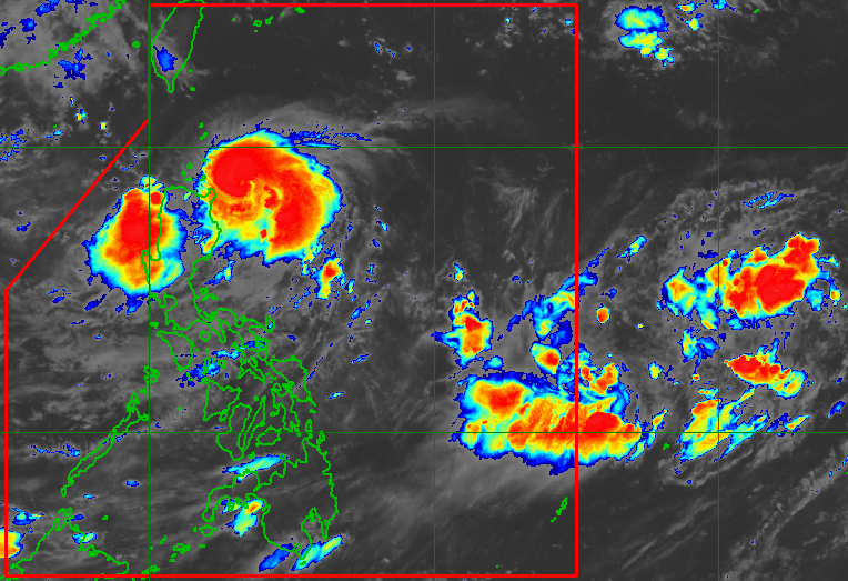
MANILA, Philippines – Typhoon Goring (Saola) rapidly intensified further before dawn on Saturday, August 26, with its maximum sustained winds increasing from 120 kilometers per hour to 140 km/h.
Its gustiness is now up to 170 km/h from the previous 150 km/h.
The Philippine Atmospheric, Geophysical, and Astronomical Services Administration (PAGASA) said Goring will continue to strengthen and may become a super typhoon on Monday, August 28 – a regular holiday in the country for National Heroes Day.
As of 4 am on Saturday, Goring was located 200 kilometers east southeast of Calayan, Cagayan, or 185 kilometers east northeast of Aparri, Cagayan.
The typhoon is moving southwest, still at only 10 km/h.
ALSO ON RAPPLER
- Clarkson says calls did not go Gilas Pilipinas’ way, shifts focus on Angola
- ‘Fantastic’ AJ Edu holds own against NBA All-Star Towns
- Odd man out: Kai Sotto loses minutes to foul trouble, excellent Fajardo, Edu outings
PAGASA updated its rainfall forecast, with the eastern part of mainland Cagayan facing the heaviest rain during the weekend. Floods and landslides are possible in areas affected by Goring.
Saturday, August 26
- 100-200 millimeters (mm): eastern part of mainland Cagayan
- 50-100 mm: Babuyan Islands, rest of mainland Cagayan, northeastern part of Isabela, Abra, northern part of Apayao, Ilocos Norte, Ilocos Sur
Sunday, August 27
- 100-200 mm: eastern part of mainland Cagayan
- 50-100 mm: Babuyan Islands, rest of mainland Cagayan, eastern part of Isabela, Ilocos Norte, northern part of Aurora
A few more areas have also been placed under tropical cyclone wind signals. Here is the list as of 5 am on Saturday:
Signal No. 2
Gale-force winds (62 to 88 km/h), minor to moderate threat to life and property
- extreme northeastern part of mainland Cagayan (Santa Ana, Gonzaga)
- extreme northeastern part of Isabela (Divilacan, Palanan, Maconacon)
Signal No. 1
Strong winds (39 to 61 km/h), minimal to minor threat to life and property
- Batanes
- Babuyan Islands
- eastern part of mainland Cagayan (Lal-lo, Gattaran, Baggao, Peñablanca, Santa Teresita, Buguey, Camalaniugan, Aparri, Ballesteros, Allacapan)
- eastern part of Isabela (Dinapigue, San Mariano, San Pablo, Cabagan, Tumauini, Ilagan City)
- northern part of Aurora (Dilasag, Casiguran)
For coastal waters, another gale warning was issued at 5 am on Saturday. Rough to very rough seas are seen in these seaboards:
- northern and eastern seaboards of Northern Luzon (Batanes, Cagayan including Babuyan Islands, Isabela) – waves 2.8 to 5 meters high
- eastern seaboard of Central Luzon (Aurora) – waves 2.8 to 4.5 meters high
PAGASA advised fishing boats and other small vessels not to sail, and larger vessels to watch out for big waves.
Goring is projected to move south to southeast on Saturday and Sunday, August 27, then turn east to northeast on Sunday.
“Afterwards, the typhoon will exit its looping path and move northwestward towards the sea east of Taiwan,” PAGASA said.
Taiwan is within the Philippine Area of Responsibility (PAR).
By late Monday or early Tuesday, August 29, “upwelling of cooler waters due to its slow movement will limit further intensification,” added the weather bureau.

Goring is also enhancing the southwest monsoon or habagat, which is still affecting Central Luzon, Southern Luzon, the Visayas, and Mindanao on Saturday.
Scattered rain showers and thunderstorms due to the enhanced southwest monsoon are expected in Metro Manila, Calabarzon, Mimaropa, and the rest of Central Luzon. Elsewhere, there may be isolated rain showers or thunderstorms.
The enhanced southwest monsoon will also trigger gusty conditions in these areas:
Saturday, August 26
- Aurora, Bataan, Metro Manila, Calabarzon, Bicol, most of Mimaropa
Sunday, August 27
- Aurora, Bataan, Metro Manila, Calabarzon, Mimaropa, Bicol, Visayas, Dinagat Islands, Camiguin
Monday, August 28
- Aurora, Bataan, Metro Manila, Calabarzon, Mimaropa, Bicol, Visayas, Dinagat Islands, Camiguin, most of Zamboanga Peninsula
Goring is the Philippines’ seventh tropical cyclone for 2023 and the first for August.
PAGASA previously said it expects two or three tropical cyclones to develop within or enter PAR in August.
The weather bureau also continues to monitor a low pressure area (LPA) outside PAR, located 1,925 kilometers east of Southern Luzon early Saturday.
PAGASA Weather Specialist Benison Estareja said the LPA will remain far from the country and will have no direct effect. – Rappler.com
Add a comment
How does this make you feel?


There are no comments yet. Add your comment to start the conversation.