SUMMARY
This is AI generated summarization, which may have errors. For context, always refer to the full article.
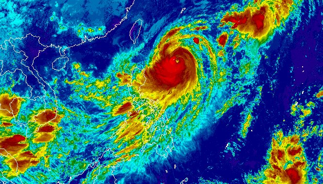
MANILA, Philippines – Typhoon Jenny (Koinu) strengthened further and slightly accelerated over the Philippine Sea on Monday morning, October 2, while still enhancing the southwest monsoon or habagat.
Jenny’s maximum sustained winds increased from 120 kilometers per hour to 140 km/h, said the Philippine Atmospheric, Geophysical, and Astronomical Services Administration (PAGASA) in a briefing past 11 am on Monday.
The typhoon now has gustiness of up to 170 km/h from the previous 150 km/h.
It was already 600 kilometers east of Calayan, Cagayan, moving northwest at a slightly faster 15 km/h from the previous 10 km/h.
PAGASA updated its rainfall forecast for Jenny, covering the next two days. Affected areas should be on alert for floods and landslides.
Monday noon, October 2, to Tuesday noon, October 3
- 50-100 millimeters (mm): Batanes, Babuyan Islands, Ilocos Norte, Ilocos Sur, northern part of mainland Cagayan
Tuesday noon, October 3, to Wednesday noon, October 4
- 100-200 mm: Batanes
- 50-100 mm: Babuyan Islands, Ilocos Norte, Ilocos Sur, northern part of mainland Cagayan, northern part of Apayao
Signal No. 1 has also been raised in more areas as of 11 am on Monday. Jenny will bring strong winds to the following:
- Batanes
- Cagayan including Babuyan Islands
- northern and eastern parts of Isabela (Maconacon, Divilacan, Palanan, Santa Maria, San Pablo, Tumauini, Cabagan, Ilagan City, San Mariano, Santo Tomas)
- Apayao
- northern part of Ilocos Norte (Carasi, Vintar, Burgos, Dumalneg, Bangui, Pagudpud, Adams)
PAGASA said Signal No. 2 is most likely the highest wind signal that will be raised due to the typhoon, though it is not ruling out Signal No. 3.
ALSO ON RAPPLER
- Marcos, Duterte approval scores drop double digits in September – Pulse Asia
- LIVE UPDATES: Philippines vs Qatar – 19th Asian Games basketball
- Hidilyn Diaz, Elreen Ando hope to lift PH to more golds in Asian Games
- Well-deserved rest for EJ Obiena after ending season with Asian Games crown
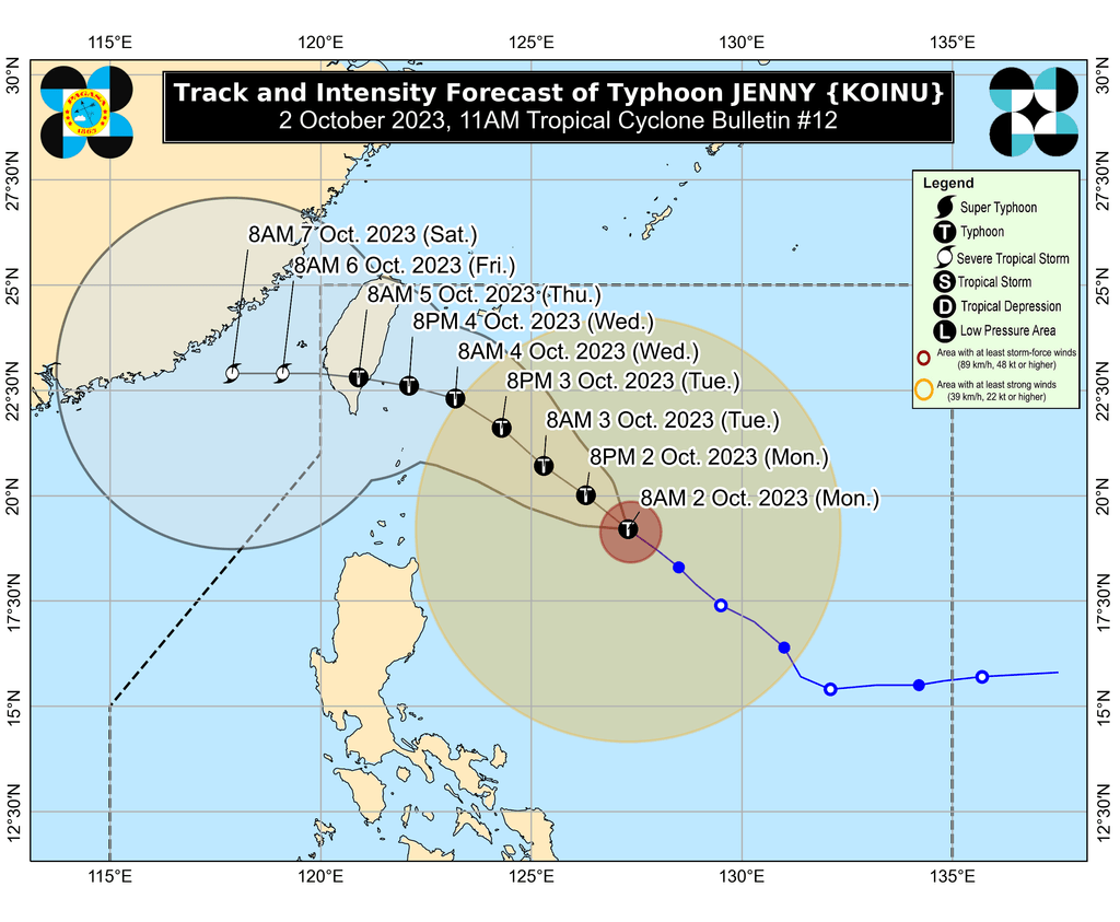
Jenny is projected to head northwest until Wednesday, October 4, before turning west northwest or west.
It is expected to make landfall in the southern part of Taiwan on Thursday morning, October 5. Taiwan is within the Philippine Area of Responsibility (PAR).
Afterwards, the typhoon could leave PAR between Thursday evening and early Friday morning, October 6, as it emerges over the Taiwan Strait.
“A landfall or close approach scenario over the Batanes area is still not ruled out, although the likelihood is decreasing,” PAGASA said.
In terms of strength, Jenny may reach its peak intensity on Tuesday, October 3, then start slightly weakening by mid-Wednesday. But it is projected to remain a typhoon.
Jenny also continues to enhance the southwest monsoon or habagat, which PAGASA warned would bring a “significant amount” of rain.
Below are the areas set to be hit by moderate to heavy rain from the enhanced southwest monsoon. Floods and landslides are possible.
Monday, October 2
- 50-100 mm: Occidental Mindoro, Palawan, Western Visayas
Tuesday, October 3
- 50-100 mm: Zambales, Bataan, Occidental Mindoro, northern part of Palawan including Calamian, Cuyo, and Kalayaan Islands, Antique
Wednesday, October 4
- 50-100 mm: Metro Manila, Zambales, Bataan, Pampanga, Bulacan, Cavite, Batangas, Occidental Mindoro, Calamian Islands, Kalayaan Islands
Gusty conditions due to the enhanced southwest monsoon will also be felt in these areas:
Monday, October 2
- most of Mimaropa, Bicol, Western Visayas
Tuesday, October 3
- Metro Manila, Calabarzon, Mimaropa, Bicol, Western Visayas
Wednesday, October 4
- Bataan, southern part of Aurora, Metro Manila, Calabarzon, northern part of Palawan including Calamian Islands, Romblon, Occidental Mindoro, parts of Bicol
For coastal waters, PAGASA released a new gale warning at 11 am on Monday. The northern and eastern seaboards of Northern Luzon – specifically Batanes and Cagayan including Babuyan Islands – have rough to very rough seas, with waves 2.8 to 4.5 meters high. Travel is risky for small vessels.
The typhoon is also causing moderate to rough seas in the coastal waters of Isabela, with waves 2 to 4 meters high. The weather bureau advised small vessels to take precautionary measures or avoid sailing, if possible.
Jenny is the Philippines’ 10th tropical cyclone for 2023 and the second for September, having developed last Friday, September 29.
PAGASA expects four to seven tropical cyclones to form within or enter PAR from October 2023 to March 2024. For October alone, there may be two or three tropical cyclones. – Rappler.com
Add a comment
How does this make you feel?


There are no comments yet. Add your comment to start the conversation.