SUMMARY
This is AI generated summarization, which may have errors. For context, always refer to the full article.
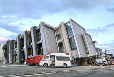
![[ANALYSIS] Lessons in resilience from Japan’s New Year’s Day earthquake](https://www.rappler.com/tachyon/2024/01/TL-japan-earthquake-warning-system-jan-3-2024.jpg)
About 15 minutes before four in the afternoon of the first day of 2024 (Manila time), a colleague sent a video message to our chat group of university earthquake scientists and engineers, showing a cup of tea on a table vigorously shaking. The caption simply stated: “Jan 1, 2024 earthquake.” That colleague was in Nagoya, Japan located about 250 kilometers south of the epicenter of a magnitude 7.6 earthquake that hit the Noto Peninsula in the prefecture of Ishikawa in western central Japan on that day, around 4:10 in the afternoon (Japan local time).
Basing from several earthquake parameters such as the epicentral location, magnitude and expected direction of displacement of the seabed, the Japan Meteorological Agency (JMA) immediately released a tsunami warning that estimated wave heights of as tall as 5 meters. JMA advised the public in coastal areas to seek higher ground, and warned the general populace in the vicinity to expect more strong tremors within a week, especially within the next two to three days, that may cause further damage.
News reports of infrastructure damage then poured in the next minutes, which included collapsed buildings, landslides, ruptured roads, buckled pavements, and fires ignited by broken gas pipelines. By January 2, at least 55 people have been reported dead.
The Noto Peninsula is located on the western coast of central Japan. Seismic tremors are rarer on the western coast because of Japan’s tectonic setting. The known earthquake generators – like the Japan Trench that caused the deadly magnitude 9.1 earthquake of Tohoku in northern Japan in 2011, the Nankai Trough located offshore south of big cities like Tokyo, Osaka, Shikoku and Nagasaki, and the Ryukyu Trench that extends all the way to eastern Taiwan – are all located to the east and south of the archipelago.
So what caused the Noto Peninsula earthquake, and why was it so damaging?
In central Japan, the oceanic lithospheres of the Pacific and Philippine Sea plates subduct, or slide beneath, the Japanese islands. This produces the system of active trenches – deep, elongated, offshore depressions – on the eastern and southern coasts of Japan that are responsible for the generation of numerous and large magnitude earthquakes.
To the west however, there is no known active trench. The Noto Peninsula earthquake must have been generated by a non-trench related fault cutting through the shallower layers of the Japanese crust that overrides the Pacific and Philippine Sea oceanic lithospheres.
Visualize through your palms
To visualize this tectonic scenario, place both palms facing down (fingers tucked together) at eye level with the tip of the middle fingers barely touching each other. The right palm represents the Pacific Plate, the left palm the central Japanese islands. Then slide the right palm underneath the left palm by bending the former by around 45 degrees downwards, such that the tip of the left middle finger now touches the main knuckle of the right middle finger. The right palm has just “subducted” underneath the left palm.
JMA estimated the focal depth – depth at which the seismic energy emanates – to be around 10 kilometers. For earthquakes, this focal depth is relatively shallow. Large magnitude, shallow earthquakes tend to inflict greater damage to infrastructure since the generated seismic waves travel a shorter distance, allowing them to retain their strength as they reach the surface causing intense shaking and sometimes breaking of the ground. In the palm analogy, the Noto earthquake originated from the rupturing of a fault located right about halfway into the knuckle of the left middle finger. The knuckle surface protrusion “is” the Noto Peninsula.
For comparison, the December 2, 2023 earthquake of Surigao del Sur that measured exactly the same magnitude of 7.6, did not inflict as much damage. Although releasing exactly the same amount of energy, the earthquake emanated from a deeper focal depth of 26 kilometers, allowing the seismic waves to dissipate more before they reached the surface, hence less energy to cause as intense a ground shaking.
In the palm analogy, the Surigao quake emanated somewhere between the main knuckle and middle joint of the right middle finger.
Earthquake early warning and resilience
The colleague in Nagoya also sent messages describing how efficient the Japanese earthquake early warning (EEW) system is. He received an EEW notification through mobile phone several seconds before the building within which he was located started shaking.
EEWs work using the principle that seismic waves travel much slower than communication signals sent either through radio waves or via the internet. Hence, if a seismometer (instrument that detects ground motion) records an earthquake from a nearby epicenter, a communication can be sent from that seismometer location to some other place farther away where the seismic waves are expected to arrive.
The time it takes the waves to travel will allow for appropriate preparation on the part of the recipients of the warning. The farther the recipient, the more preparation time is availed. Traveling at an average speed of 2.5 kilometers per second, surface waves from Noto needed 100 seconds to reach Nagoya.
Recent mobile phones are equipped with sensors that detect motion, such as when the phone is rotated or tilted. These sensors are now used by android systems as mini-seismometers to detect motion. When many phones clustered within an area detect motion at the same precise time, it is possible that the cause of the detected movement is an earthquake.
![[ANALYSIS] June 15’s magnitude 6.3 deep-focus Calatagan earthquake](https://www.rappler.com/tachyon/2023/06/tl-calatagan-earthquake.jpg?fit=449%2C449)
A system can then be designed to calculate earthquake parameters such as location and magnitude, and send these information to all mobile phones within a distance expected to be reached by the eventual shaking of the ground. I have experienced receiving such mobile messages for recent Philippine earthquakes, such as during the magnitude 6.3 Calatagan (Batangas) earthquake of June 15, 2023.
EEW is a step forward in the quest for earthquake disaster resilience. Institutions engaged in earthquake research should now train their sights on efforts in developing an EEW system that will make the Filipino more resilient to earthquakes. – Rappler.com
Mario A. Aurelio, PhD is a professor at the National Institute of Geological Sciences-University of the Philippines, interested in the study of earthquakes. He is part of a UP team engaged in developing strategies to enhance disaster resilience against earthquakes in the country.
Add a comment
How does this make you feel?


![[Hindi ito Marites] Japan: From enemy to bestie](https://www.rappler.com/tachyon/2024/07/Hindi-ito-Marites-TC-ls-7.jpg?resize=257%2C257&crop=415px%2C0px%2C1080px%2C1080px)


![[Rappler’s Best] America](https://www.rappler.com/tachyon/2024/07/rapplers-best-america.jpg?resize=257%2C257&crop=458px%2C0px%2C1080px%2C1080px)
There are no comments yet. Add your comment to start the conversation.