SUMMARY
This is AI generated summarization, which may have errors. For context, always refer to the full article.
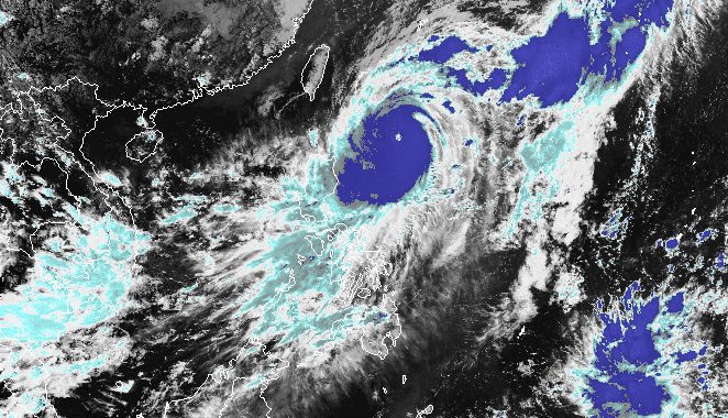
MANILA, Philippines – Typhoon Jenny (Koinu) is still steadily intensifying over the Philippine Sea, the country’s weather bureau warned on Monday afternoon, October 2.
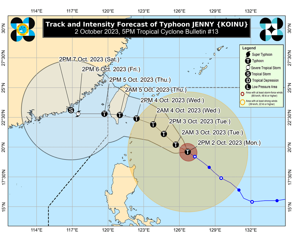
The Philippine Atmospheric, Geophysical, and Astronomical Services Administration (PAGASA) said in its 5 pm bulletin on Monday that Jenny now has maximum sustained winds of 155 kilometers per hour from the previous 140 km/h.
The typhoon’s gustiness is now up to 190 km/h from 170 km/h.
PAGASA said Jenny could reach its peak intensity on Tuesday, October 3, then start slightly weakening by mid-Wednesday, October 4, but it would remain a typhoon.
As of 4 pm on Monday, Jenny was located 485 kilometers east of Basco, Batanes, still moving northwest at 15 km/h. It is seen to maintain its northwest direction until Wednesday before turning west northwest or west.
Jenny’s latest forecast track shows landfall in the Philippines is now unlikely. Instead, the typhoon is expected to make landfall in the southern part of Taiwan on Thursday morning, October 5. Taiwan is within the Philippine Area of Responsibility (PAR).
But given Jenny’s size, it is still affecting Northern Luzon. PAGASA warned that rain from the typhoon may cause floods and landslides in the next two days.
Monday afternoon, October 2, to Tuesday afternoon, October 3
- 50-100 millimeters (mm): Batanes, Cagayan including Babuyan Islands, Ilocos Norte, Ilocos Sur, Isabela
Tuesday afternoon, October 3, to Wednesday afternoon, October 4
- 100-200 mm: Batanes
- 50-100 mm: Babuyan Islands, Ilocos Norte, Ilocos Sur, northern part of mainland Cagayan, northern part of Apayao
More areas were also placed under Signal No. 1 as of 5 pm on Monday, which means they will face strong winds due to Jenny:
- Batanes
- Cagayan including Babuyan Islands
- northern and eastern parts of Isabela (Maconacon, Divilacan, Palanan, Santa Maria, San Pablo, Tumauini, Cabagan, Ilagan City, San Mariano, Santo Tomas, Dinapigue, Benito Soliven, Naguilian, Gamu, Quirino, Delfin Albano, Quezon, Mallig)
- Apayao
- northern and central parts of Ilocos Norte (Carasi, Vintar, Burgos, Dumalneg, Bangui, Pagudpud, Adams, Nueva Era, Pasuquin, Bacarra, Laoag City, San Nicolas, Sarrat, Piddig, Dingras, Solsona, Marcos)
- northeastern part of Abra (Tineg, Lacub, Malibcong)
- northern part of Kalinga (Balbalan, Pinukpuk, Rizal, Tabuk City)
PAGASA said Signal No. 2 is most likely the highest wind signal that will be raised due to the typhoon, though it is not ruling out Signal No. 3.
ALSO ON RAPPLER
- Gilas Pilipinas crushes Qatar to set up quarterfinal date with Iran in Asian Games
- Hidilyn Diaz falls short of weightlifting medal, places 4th in Asian Games
- ‘Surviving all side effects’: Kris Aquino shares new update on her autoimmune condition
- [EDITORIAL] Magic confidential funds – now you see it, now you don’t
Jenny is also still enhancing the southwest monsoon or habagat, which PAGASA earlier warned would bring a “significant amount” of rain.
The following areas to be affected by the enhanced southwest monsoon should watch out for floods and landslides as well:
Monday, October 2
- 50-100 mm: Occidental Mindoro, Palawan, Western Visayas
Tuesday, October 3
- 50-100 mm: Zambales, Bataan, Occidental Mindoro, northern part of Palawan including Calamian, Cuyo, and Kalayaan Islands, Antique
Wednesday, October 4
- 50-100 mm: Metro Manila, Zambales, Bataan, Pampanga, Bulacan, Cavite, Batangas, Occidental Mindoro, Calamian Islands, Kalayaan Islands
Gusty conditions due to the enhanced southwest monsoon will also be felt in these areas:
Monday, October 2
- most of Mimaropa, Bicol, Western Visayas
Tuesday, October 3
- Metro Manila, Calabarzon, Mimaropa, Bicol, Western Visayas
Wednesday, October 4
- Bataan, southern part of Aurora, Metro Manila, Calabarzon, northern part of Palawan including Calamian Islands, Romblon, Occidental Mindoro, parts of Bicol
For coastal waters, PAGASA issued a new gale warning at 5 pm on Monday. Rough to very rough seas will persist in the northern and eastern seaboards of Northern Luzon, specifically Batanes and Cagayan including Babuyan Islands. Travel is risky for small vessels as waves are 2.8 to 5 meters high.
The typhoon is also causing moderate to rough seas in the coastal waters of Isabela, with waves 2 to 4 meters high. The weather bureau advised small vessels to take precautionary measures or avoid sailing, if possible.
Jenny is the Philippines’ 10th tropical cyclone for 2023 and the second for September, having developed last Friday, September 29.
PAGASA expects four to seven tropical cyclones to form within or enter PAR from October 2023 to March 2024. For October alone, there may be two or three tropical cyclones. – Rappler.com
Add a comment
How does this make you feel?


There are no comments yet. Add your comment to start the conversation.