SUMMARY
This is AI generated summarization, which may have errors. For context, always refer to the full article.
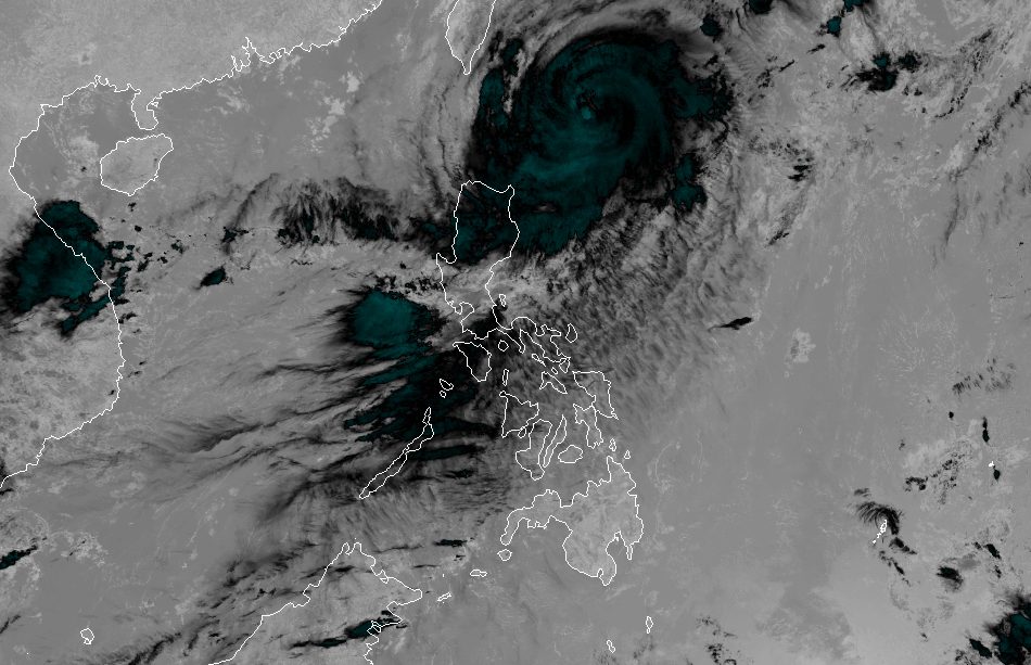
MANILA, Philippines – Typhoon Jenny (Koinu) slightly weakened on Tuesday morning, October 3, but rainfall and wind warnings are still in effect.
Jenny’s maximum sustained winds decreased from 165 kilometers per hour to 155 km/h, said the Philippine Atmospheric, Geophysical, and Astronomical Services Administration (PAGASA) in its 11 am bulletin on Tuesday.
The typhoon’s gustiness eased from 205 km/h to 190 km/h.
It was last spotted 330 kilometers east of Basco, Batanes, or 340 kilometers east of Itbayat, Batanes, moving northwest at a slightly slower 10 km/h from the previous 15 km/h.
While Jenny is still unlikely to make landfall in the Philippines, it is bringing heavy rain to the country’s northernmost areas. Floods and landslides are possible in the next two days.
Tuesday noon, October 3, to Wednesday noon, October 4
- 50-100 millimeters (mm): Batanes, Babuyan Islands
Wednesday noon, October 4, to Thursday noon, October 5
- 100-200 mm: Batanes
- 50-100 mm: Babuyan Islands, northern part of Ilocos Norte
The same areas are under tropical cyclone wind signals as of 11 am on Tuesday:
Signal No. 2
Gale-force winds (62 to 88 km/h), minor to moderate threat to life and property
- Batanes
Signal No. 1
Strong winds (39 to 61 km/h), minimal to minor threat to life and property
- Cagayan including Babuyan Islands
- northern and eastern parts of Isabela (Maconacon, Divilacan, Palanan, Santa Maria, San Pablo, Tumauini, Cabagan, Ilagan City, San Mariano, Santo Tomas, Dinapigue, Benito Soliven, Naguilian, Gamu, Quirino, Delfin Albano, Quezon, Mallig)
- Apayao
- northeastern part of Abra (Tineg, Lacub, Malibcong)
- northern part of Kalinga (Balbalan, Pinukpuk, Rizal, Tabuk City)
- Ilocos Norte
PAGASA said Signal No. 3 is most likely the highest wind signal that will be raised due to Jenny.
ALSO ON RAPPLER
- Palawan congressman Edward Hagedorn, Puerto Princesa’s longtime face, dies
- LIVE UPDATES: Philippines vs Iran – 19th Asian Games basketball quarterfinal
- Carlos Yulo admits ‘pros and cons’ of coaching change after parting ways with Japanese mentor
- Miss World 2023 set for December in India
The typhoon is projected to head northwest or west northwest until Wednesday, October 4, before turning west.
It could make landfall in the southern part of Taiwan between late Wednesday evening and Thursday morning, October 5, then leave the Philippine Area of Responsibility between Thursday morning and afternoon. Taiwan is within PAR.
Outside PAR, Jenny will slowly move west over the Taiwan Strait, toward the coastal waters of southern China.
PAGASA added that the typhoon will further weaken once it hits Taiwan’s rugged terrain and as it emerges over the Taiwan Strait, where it will again interact with dry air.

Jenny also continues to enhance the southwest monsoon or habagat, which is causing a “significant amount” of rain.
These areas affected by moderate to heavy rain from the enhanced southwest monsoon must stay on alert for floods and landslides:
Tuesday, October 3
- 50-100 mm: Zambales, Bataan, Occidental Mindoro, northern part of Palawan including Calamian, Cuyo, and Kalayaan islands, Antique
Wednesday, October 4
- 50-100 mm: Zambales, Bataan, Pampanga, Bulacan, Metro Manila, Cavite, Batangas, Occidental Mindoro, Calamian Islands, Cuyo Islands
Thursday, October 5
- 50-100 mm: La Union, Pangasinan, Benguet, Zambales, Bataan, Tarlac, Pampanga, Bulacan, Metro Manila, Cavite, Batangas, Occidental Mindoro
Gusty conditions due to the enhanced southwest monsoon are also seen in these areas:
Tuesday, October 3
- Aurora, Bataan, Bulacan, Metro Manila, Calabarzon, Bicol, most of Mimaropa, most of Western Visayas
Wednesday, October 4
- Bataan, southern part of Aurora, Metro Manila, Calabarzon, most of Bicol, Romblon
Thursday, October 5
- parts of Calabarzon, parts of Bicol, Romblon
Meanwhile, the gale warning issued at 5 am on Tuesday remains in effect, covering the following seaboards:
- northern seaboard of Northern Luzon (Batanes, northern coast of Cagayan including Babuyan Islands) – rough to high seas, waves 3.1 to 6 meters high, travel risky for all vessels
- eastern seaboard of Northern Luzon (eastern coast of Cagayan, Isabela) – rough to very rough seas, waves 2.8 to 4.5 meters high, travel risky for small vessels
The typhoon is also causing moderate to rough seas in the coastal waters of northern Aurora, with waves 1.5 to 3.5 meters high. The weather bureau advised small vessels to take precautionary measures or avoid sailing, if possible.
Jenny is the Philippines’ 10th tropical cyclone for 2023 and the second for September, having developed last Friday, September 29.
PAGASA expects four to seven tropical cyclones to form within or enter PAR from October 2023 to March 2024. For October alone, there may be two or three tropical cyclones. – Rappler.com
Add a comment
How does this make you feel?


There are no comments yet. Add your comment to start the conversation.