SUMMARY
This is AI generated summarization, which may have errors. For context, always refer to the full article.
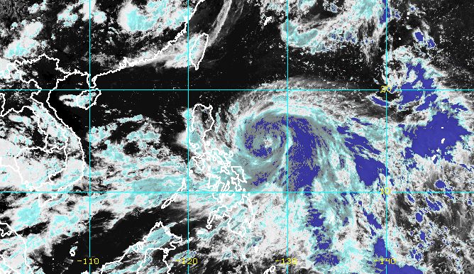
MANILA, Philippines – The state weather bureau raised Signal No. 1 for the first time due to Severe Tropical Storm Egay (Doksuri), which continued to strengthen on Sunday afternoon, July 23.
Egay’s maximum sustained winds increased from 95 kilometers per hour to 110 km/h, while its gustiness is now up to 135 km/h from the previous 115 km/h.
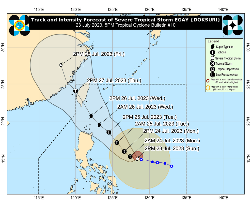
The Philippine Atmospheric, Geophysical, and Astronomical Services Administration (PAGASA) said in a briefing past 5 pm on Sunday that Egay is still expected to intensify into a typhoon within 24 hours and into a super typhoon on Tuesday, July 25. Rapid intensification remains likely “due to favorable atmospheric and oceanic conditions.”
The severe tropical storm was already 560 kilometers east of Daet, Camarines Norte, on Sunday afternoon, moving west northwest at a slightly slower 10 km/h from the previous 15 km/h.
Signal No. 1 is now raised in these areas, which should prepare for strong winds from Egay:
- Catanduanes
- eastern part of Camarines Sur (Garchitorena, Caramoan, Presentacion)
- northern part of Aurora (Casiguran, Dilasag)
- eastern part of Isabela (Dinapigue, Divilacan, Maconacon, Palanan, Ilagan City, San Mariano, Tumauini, San Pablo, Cabagan)
- eastern part of Cagayan (Santa Ana, Gonzaga, Lal-lo, Gattaran, Baggao, Peñablanca)
- northern part of Eastern Samar (San Policarpo, Oras, Arteche, Jipapad)
- eastern part of Northern Samar (Lapinig, Gamay, Mapanas, Palapag, Laoang, Catubig, Pambujan)
The highest possible wind signal is Signal No. 3 or 4, probably in extreme Northern Luzon.
“However, should a southward shift in the track occur, higher wind signals may be hoisted,” PAGASA said.
Egay is also bringing heavy rain which may trigger floods and landslides. The weather bureau maintained the following rainfall forecast for the severe tropical storm:
Sunday, July 23
- 50-100 millimeters (mm): Catanduanes
Monday, July 24
- 100-200 mm: Catanduanes
- 50-100 mm: Cagayan, eastern part of Isabela, Polillo Islands, Camarines Norte, Camarines Sur, Albay
Tuesday, July 25
- Greater than 200 mm: Batanes, Babuyan Islands, northeastern part of mainland Cagayan, northern part of Ilocos Norte
- 100-200 mm: Apayao, Abra, rest of Ilocos Norte, Ilocos Sur, La Union, rest of Cagayan
- 50-100 mm: Pangasinan, Isabela, rest of Cordillera Administrative Region
PAGASA added in its separate daily forecast that scattered rain showers and thunderstorms are hitting the rest of Bicol and Eastern Visayas on Sunday, still due to Egay.
The weather bureau sees Egay moving west northwest or west in the next 12 hours or until early Monday, July 24, then heading northwest until Thursday, July 27.
Egay is still expected to “remain offshore for most of the forecast period,” but the weather bureau is not ruling out “a close approach or landfall in the vicinity of extreme Northern Luzon.” The tropical cyclone will be closest to extreme Northern Luzon on Wednesday, July 26.
The ridge of a high pressure area north of Egay has also been influencing its movement. Because of this ridge, PAGASA said a westward shift in the track – more toward Philippine landmass – is a possibility.
Meanwhile, PAGASA issued a new gale warning at 5 pm on Sunday, covering certain coastal waters along the eastern seaboards of Northern Luzon, Southern Luzon, the Visayas, and Mindanao. Waters are rough to very rough, with waves 2.8 to 4.5 meters high, due to Egay:
- eastern coast of Cagayan, Isabela, Camarines Norte, Camarines Sur, Catanduanes, Albay, Sorsogon
- northern and eastern coasts of Northern Samar
- Eastern Samar
- eastern coast of Surigao del Norte including Siargao and Bucas Grande islands
- Dinagat Islands
The weather bureau advised fishing boats and other small vessels not to sail, and larger vessels to watch out for big waves.
In coastal waters along the eastern seaboards of Luzon, the Visayas, and Mindanao that are not covered by the gale warning, Egay might cause rough seas, with waves 2.8 to 3.5 meters high. Small vessels should take precautionary measures.
Egay is also enhancing the southwest monsoon or habagat, which is affecting Southern Luzon, the Visayas, and Mindanao on Sunday.
The enhanced southwest monsoon is causing scattered to isolated rain showers and thunderstorms.
Many areas might also experience gusty conditions due to the enhanced southwest monsoon:
Sunday, July 23
- Mimaropa, Visayas, and northern parts of Zamboanga Peninsula, Northern Mindanao, Caraga
Monday, July 24
- Calabarzon, Mimaropa, Visayas, Zamboanga Peninsula, and northern parts of Northern Mindanao and Caraga
Tuesday, July 25
- Most of Luzon, most of Visayas, northern part of Zamboanga Peninsula, Dinagat Islands
PAGASA also said Egay could make landfall in Taiwan on Thursday morning. Taiwan is still within the Philippine Area of Responsibility (PAR).
Before Egay hits Taiwan, “a slight weakening trend” might begin on Wednesday.
“Interaction with the mountainous terrain of Taiwan will result in further weakening – a trend which will continue until the tropical cyclone makes another landfall in mainland China,” the weather bureau added.
Egay is the Philippines’ fifth tropical cyclone for 2023 and the second for July. PAGASA earlier estimated that two to four tropical cyclones would form inside or enter PAR during the month. – Rappler.com
Add a comment
How does this make you feel?


There are no comments yet. Add your comment to start the conversation.