SUMMARY
This is AI generated summarization, which may have errors. For context, always refer to the full article.
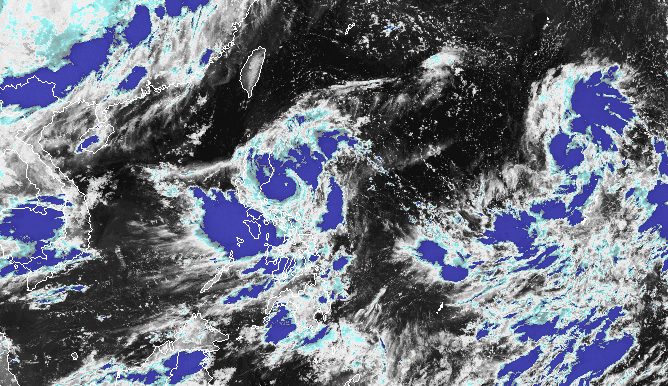
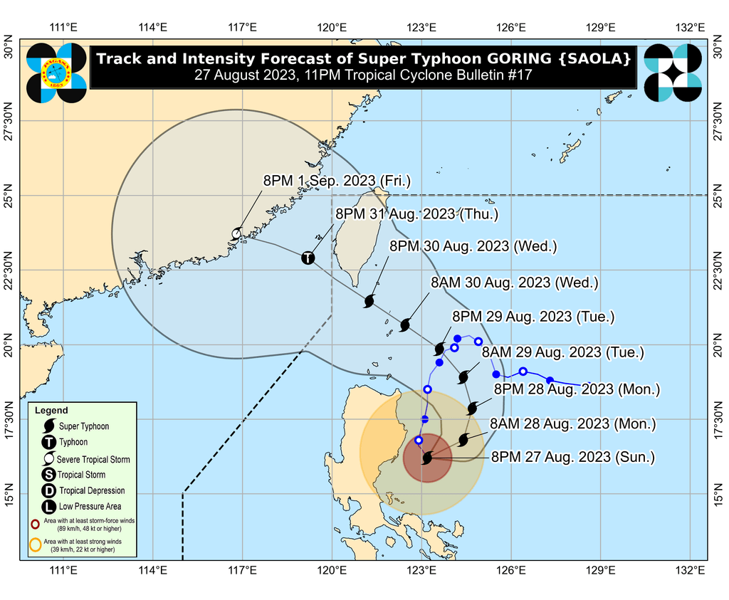
MANILA, Philippines – Super Typhoon Goring (Saola) began its counterclockwise loop over the Philippine Sea on Sunday evening, August 27.
In a bulletin issued at 11 pm on Sunday, the Philippine Atmospheric, Geophysical, and Astronomical Services Administration (PAGASA) said Goring was located 125 kilometers east of Casiguran, Aurora.
From a south southeast direction or generally downward movement, the super typhoon shifted east southeast as it started its loop. Its speed is just 10 kilometers per hour (km/h).
PAGASA said Goring is expected to continue its counterclockwise looping path until Monday, August 28, before turning northwest on Tuesday, August 29.
The weather bureau is now warning that the super typhoon could go near Batanes between Wednesday morning and evening, August 30, and the southern part of Taiwan between Wednesday evening and Thursday morning, August 31. Landfall is not being ruled out.
As of Sunday evening, Goring still had maximum sustained winds of 185 km/h and gustiness of up to 230 km/h.
“Goring is forecast to remain at super typhoon category until its close approach to Taiwan, although a slight weakening in the near term – e.g. next 12 or 24 hours – is not ruled out,” PAGASA said.
“Interaction with the rugged terrain of Taiwan during its close approach will result in a weakening trend beginning on early Thursday.”
For the next 48 hours, as Goring completes its looping path, rain may relatively ease in affected areas in Northern Luzon. Afterwards, with the super typhoon projected to go near Batanes, torrential rain could return.
Sunday evening, August 27, to Monday evening, August 28
- 50-100 millimeters (mm): eastern part of Cagayan, Isabela
Monday evening, August 28, to Tuesday evening, August 29
- 50-100 mm: Batanes, Babuyan Islands, northern part of mainland Cagayan, northern part of Apayao, northern part of Ilocos Norte
Tuesday evening, August 29, to Wednesday evening, August 30
- Greater than 200 mm: Batanes
- 100-200 mm: Babuyan Islands
- 50-100 mm: northern part of mainland Cagayan, northern part of Apayao, northern part of Ilocos Norte
PAGASA reminded the public that floods and landslides are still possible.
Meanwhile, Signal No. 3 has been lifted, for now. But Signal Nos. 1 and 2 remain in effect in these areas as of 11 pm on Sunday:
Signal No. 2
Gale-force winds (62 to 88 km/h), minor to moderate threat to life and property
- eastern part of Isabela (Dinapigue, San Mariano, Naguilian, San Guillermo, Luna, Cauayan City, Echague, Ilagan City, Angadanan, Benito Soliven, Tumauini, Reina Mercedes, San Agustin, Palanan, Divilacan, Gamu, Jones, Maconacon)
- eastern part of Quirino (Maddela)
- extreme northern part of Aurora (Casiguran, Dinalungan, Dilasag)
Signal No. 1
Strong winds (39 to 61 km/h), minimal to minor threat to life and property
- Batanes
- Babuyan Islands
- mainland Cagayan
- rest of Isabela
- rest of Quirino
- Nueva Vizcaya
- Apayao
- Kalinga
- Abra
- Mountain Province
- Ifugao
- eastern part of Benguet (Bokod, Buguias, Kabayan, Mankayan)
- eastern part of Ilocos Norte (Pagudpud, Adams, Vintar, Carasi, Nueva Era, Banna, Marcos, Dingras, Solsona, Piddig, Dumalneg, Bangui)
- eastern part of Nueva Ecija (Carranglan, Pantabangan, Bongabon, Gabaldon, Laur, Rizal)
- rest of Aurora
- Polillo Islands
- Calaguas Islands
PAGASA explained that “due to the looping nature” of Goring’s forecast track, higher wind signals could still be raised for extreme Northern Luzon and the northern or northeastern part of mainland Cagayan.
The weather bureau is not ruling out Signal No. 3 or 4 for the Batanes-Babuyan Islands area.
ALSO ON RAPPLER
- Clarkson misfires as Gilas Pilipinas bungles prime chance vs Angola
- ‘No time for depression’: Italy refuses to dwell on shock loss, shifts focus on Gilas
- ‘Unbelievable’: Dominican Republic bolsters 2nd-round bid in Group A
- Planning to live alone for the 1st time? Here are 4 things you need to know
Goring also continues to enhance the southwest monsoon or habagat. Rain from the enhanced southwest monsoon is heaviest in the following provinces:
Sunday evening, August 27, to Monday evening, August 28
- 100-200 mm: Zambales, Bataan, Occidental Mindoro
- 50-100 mm: Cavite, Batangas, northern part of Palawan including Calamian and Cuyo islands, Antique
Monday evening, August 28, to Tuesday evening, August 29
- 100-200 mm: Zambales, Bataan, Occidental Mindoro
- 50-100 mm: Cavite, Batangas, northern part of Palawan including Calamian and Cuyo islands, Antique, southwestern part of Iloilo, northwestern part of Aklan
Tuesday evening, August 29, to Wednesday evening, August 30
- 100-200 mm: Zambales, Bataan, Occidental Mindoro
- 50-100 mm: Cavite, Batangas, Romblon, northern part of Palawan including Calamian and Cuyo islands, Antique, northwestern part of Aklan
The enhanced southwest monsoon is triggering gusty conditions in these areas as well:
Monday, August 28
- Aurora, Bataan, Metro Manila, Calabarzon, Mimaropa, Bicol, Visayas, Dinagat Islands, Camiguin, most of Zamboanga Peninsula
Tuesday, August 29
- Aurora, Bataan, Bulacan, Metro Manila, Calabarzon, Mimaropa, Bicol, Visayas, Dinagat Islands, Camiguin, most of Zamboanga Peninsula
Wednesday, August 30
- Aurora, Bataan, Zambales, Pampanga, Bulacan, Metro Manila, Calabarzon, Mimaropa, Bicol, most of Visayas
For coastal waters, the gale warning that PAGASA issued at 5 pm on Sunday remains in effect. This is due to both the super typhoon and the enhanced southwest monsoon:
- eastern seaboard of Northern Luzon (Isabela, eastern coast of Cagayan) – rough to high seas, with waves 3.1 to 6.5 meters high
- northern seaboard of Northern Luzon and eastern seaboard of Central Luzon (Batanes, Calayan, Babuyan, northern coast of Cagayan, northern coast of Ilocos Norte, Aurora) – rough to very rough seas, with waves 2.8 to 5 meters high
- eastern seaboard of Southern Luzon (northern coast of Quezon including Polillo Islands), western and southern seaboards of Southern Luzon (Palawan, Romblon, Marinduque, Occidental Mindoro, Oriental Mindoro), western seaboard of Visayas (Antique) – rough to very rough seas, with waves 2.8 to 4.5 meters high
The weather bureau advised fishing boats and other small vessels not to sail, and larger vessels to watch out for big waves.
Goring is likely to exit the Philippine Area of Responsibility (PAR) between Thursday afternoon and evening.
It is the Philippines’ seventh tropical cyclone for 2023 and the first for August. It is also the third super typhoon for the year, after Betty (Mawar) in May and Egay (Doksuri) in July.
PAGASA previously said it expects two or three tropical cyclones to develop within or enter PAR in August.
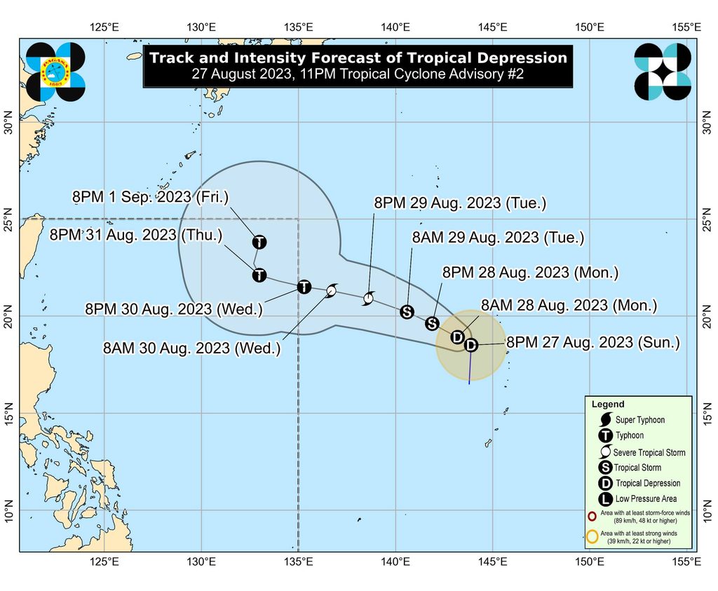
The second tropical cyclone for August could be the tropical depression that developed outside PAR on Sunday afternoon.
The tropical depression was last spotted 2,350 kilometers east of Northern Luzon on Sunday evening, moving north northwest at 15 km/h.
It continues to have maximum sustained winds of 45 km/h and gustiness of up to 55 km/h. But PAGASA said it will steadily intensify in the next five days, possibly becoming a tropical storm on Monday, a severe tropical storm on Tuesday, and a typhoon on Wednesday, before its entry into PAR.
It may enter PAR on Wednesday evening or Thursday morning, and would be given the local name Hanna.
Starting Thursday evening or Friday morning, September 1, it could turn north near the northeastern PAR boundary, which means it may stay far from landmass.
Based on that scenario, PAGASA said the potential Hanna would be “less likely” to directly affect the country.
But it could enhance the southwest monsoon beginning Wednesday or Thursday, which may lead to more monsoon rain in the western parts of Luzon and the Visayas.
– Rappler.com
Add a comment
How does this make you feel?


There are no comments yet. Add your comment to start the conversation.