SUMMARY
This is AI generated summarization, which may have errors. For context, always refer to the full article.
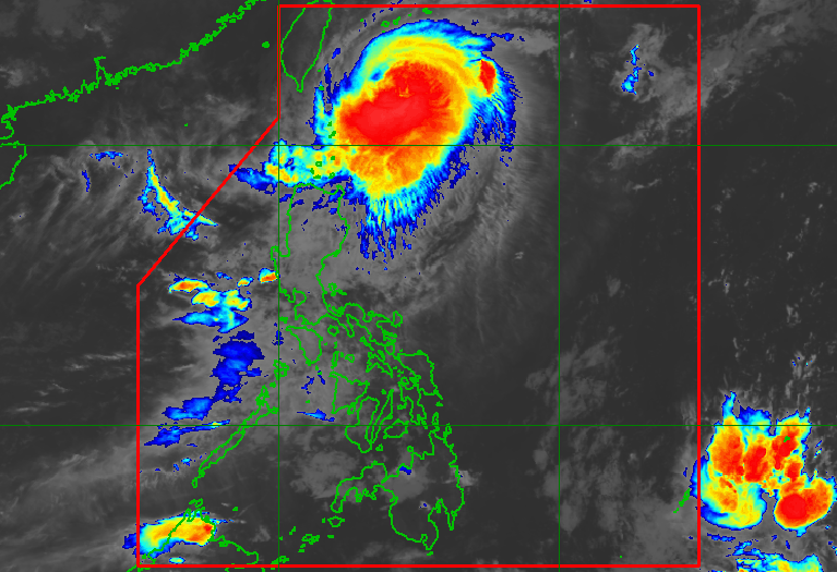
MANILA, Philippines – Signal No. 3 was raised for the municipality of Itbayat in Batanes province on Tuesday evening, October 3, as Typhoon Jenny (Koinu) maintained its strength.
Jenny was located 305 kilometers east northeast of Itbayat as of 10 pm on Tuesday, moving north northwest at only 10 kilometers per hour (km/h).
The typhoon still has maximum sustained winds of 155 km/h and gustiness of up to 190 km/h, said the Philippine Atmospheric, Geophysical, and Astronomical Services Administration (PAGASA) in its 11 pm bulletin.
Here are the areas under tropical cyclone wind signals:
Signal No. 3
Storm-force winds (89 to 117 km/h), moderate to significant threat to life and property
- northern part of Batanes (Itbayat)
Signal No. 2
Gale-force winds (62 to 88 km/h), minor to moderate threat to life and property
- rest of Batanes
Signal No. 1
Strong winds (39 to 61 km/h), minimal to minor threat to life and property
- Cagayan including Babuyan Islands
- northern part of Isabela (Maconacon, San Pablo, Santa Maria, Divilacan)
- Apayao
- northeastern part of Abra (Tineg, Lacub, Malibcong)
- northern part of Kalinga (Rizal, Pinukpuk, Balbalan)
- Ilocos Norte
Rain from Jenny will also persist in the next two days, even though the typhoon is not expected to make landfall in the Philippines. PAGASA stressed that floods and landslides are possible.
Tuesday night, October 3, to Wednesday night, October 4
- 100-200 millimeters (mm): Batanes
- 50-100 mm: Babuyan Islands
Wednesday night, October 4, to Thursday night, October 5
- 50-100 mm: Batanes, northern and western parts of Babuyan Islands, northern part of Ilocos Norte
ALSO ON RAPPLER
- Rappler Talk: A year since Percy Lapid’s murder – smokescreen justice?
- Jeepney fare hiked by P1 nationwide
- Gilas Pilipinas survives massive Iran comeback, clinches 1st Asiad semis in 21 years
- Hidilyn Diaz still all smiles after 4th-place Asiad finish, eyes Olympic qualifiers
- Trio win 2023 Nobel Prize in Physics for use of light to study electron
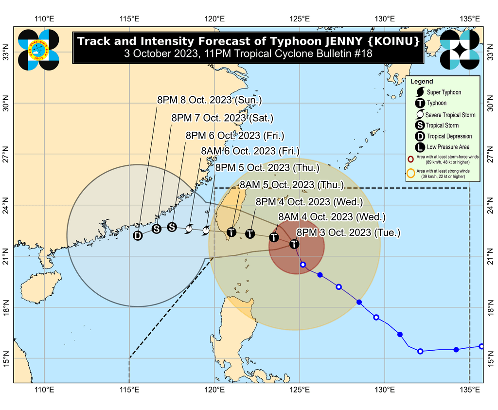
Jenny is seen to turn and move west northwest in the next 12 hours, or by Wednesday morning, October 4, then west.
It could make landfall in the southern part of Taiwan between late Wednesday evening and Thursday morning, October 5, then leave the Philippine Area of Responsibility on Thursday afternoon or evening. Taiwan is within PAR.
Outside PAR, Jenny will keep moving west over the Taiwan Strait and the coastal waters of southeastern China.
PAGASA also expects Jenny to weaken due to interaction with dry air and once it hits Taiwan’s rugged terrain.
Jenny is still enhancing the southwest monsoon or habagat as well. Rain from the enhanced southwest monsoon will persist in these areas:
Tuesday night, October 3, to Wednesday night, October 4
- 50-100 mm: Zambales, Bataan, Occidental Mindoro, northern part of Palawan including Calamian, Cuyo, and Kalayaan islands
Wednesday night, October 4, to Thursday night, October 5
- 50-100 mm: Zambales, Bataan, Pampanga, Bulacan, Metro Manila, Cavite, Batangas, Occidental Mindoro
Thursday night, October 5, to Friday night, October 6
- 50-100 mm: La Union, Pangasinan, Zambales, Bataan, Occidental Mindoro
Gusty conditions due to the enhanced southwest monsoon are also seen in these areas:
Wednesday, October 4
- southern part of Aurora, Bataan, Metro Manila, Occidental Mindoro, Kalayaan Islands, Romblon, most of Calabarzon, parts of Bicol
Thursday, October 5
- southern part of Aurora, Romblon, parts of Calabarzon, parts of Bicol
Meanwhile, the gale warning issued at 5 pm on Tuesday remains in effect, covering the following seaboards:
- northern seaboard of Northern Luzon (Batanes, northern coast of Cagayan including Babuyan Islands) – rough to high seas, waves 3.1 to 6 meters high, travel risky for all vessels
- eastern and western seaboards of Northern Luzon (Ilocos Norte, eastern coast of Cagayan, Isabela) – rough to very rough seas, waves 2.8 to 4.5 meters high, travel risky for small vessels
The typhoon is also causing moderate to rough seas in the coastal waters of northern Aurora, with waves 1.5 to 3 meters high. The weather bureau advised small vessels to take precautionary measures or avoid sailing, if possible.
Jenny is the Philippines’ 10th tropical cyclone for 2023 and the second for September, having developed last Friday, September 29.
PAGASA expects four to seven tropical cyclones to form within or enter PAR from October 2023 to March 2024. For October alone, there may be two or three tropical cyclones. – Rappler.com
Add a comment
How does this make you feel?


There are no comments yet. Add your comment to start the conversation.