SUMMARY
This is AI generated summarization, which may have errors. For context, always refer to the full article.

MANILA, Philippines – Typhoon Jenny (Koinu) maintained its strength over the Philippine Sea while still affecting Northern Luzon and enhancing the southwest monsoon or habagat early Tuesday, October 3.
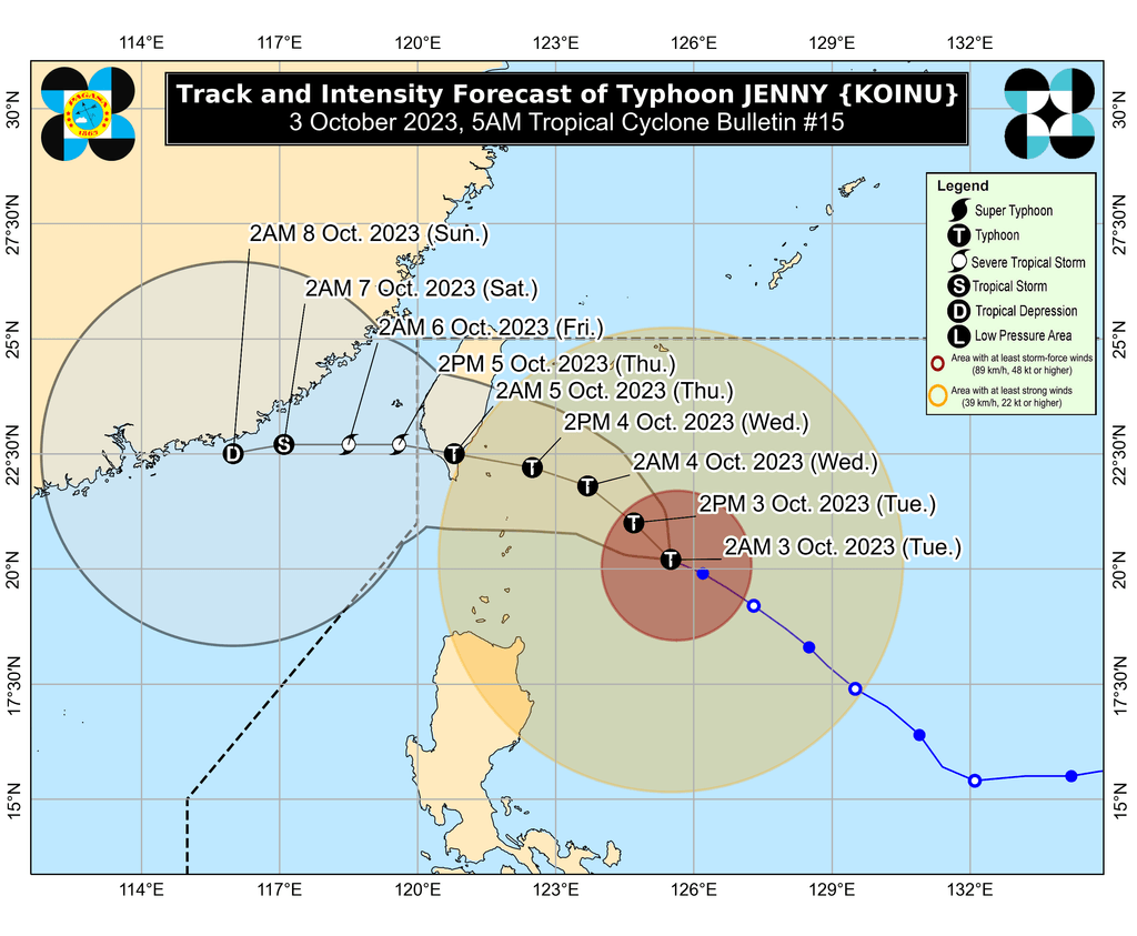
As of 4 am on Tuesday, Jenny was located 350 kilometers east of Basco, Batanes. It slightly accelerated, moving west northwest at 15 kilometers per hour from the previous 10 km/h.
The typhoon still has maximum sustained winds of 165 km/h and gustiness of up to 205 km/h. It is “likely at or near its peak intensity,” said the Philippine Atmospheric, Geophysical, and Astronomical Services Administration (PAGASA).
Jenny remains unlikely to make landfall in the Philippines, but the country’s northernmost areas are seeing heavy rain from the typhoon. Floods and landslides are possible.
Tuesday, October 3
- 50-100 millimeters (mm): Batanes, Babuyan Islands
Wednesday, October 4
- 100-200 mm: Batanes
- 50-100 mm: Babuyan Islands, northern part of Ilocos Norte
Tropical cyclone wind signals are still raised in the following areas as of 5 am on Tuesday:
Signal No. 2
Gale-force winds (62 to 88 km/h), minor to moderate threat to life and property
- Batanes
Signal No. 1
Strong winds (39 to 61 km/h), minimal to minor threat to life and property
- Cagayan including Babuyan Islands
- northern and eastern parts of Isabela (Maconacon, Divilacan, Palanan, Santa Maria, San Pablo, Tumauini, Cabagan, Ilagan City, San Mariano, Santo Tomas, Dinapigue, Benito Soliven, Naguilian, Gamu, Quirino, Delfin Albano, Quezon, Mallig)
- Apayao
- northeastern part of Abra (Tineg, Lacub, Malibcong)
- northern part of Kalinga (Balbalan, Pinukpuk, Rizal, Tabuk City)
- Ilocos Norte
PAGASA said Signal No. 3 is most likely the highest wind signal that will be raised due to Jenny.
ALSO ON RAPPLER
- Stella Quimbo, controversial star at a political crossroads
- ‘Dream come true’: PH gymnast Aleah Finnegan books Paris Olympics ticket
- Elreen Ando scores bronze for PH weightlifting in Asian Games
- Gilas Women exit Asian Games after quarterfinal loss to South Korea
The typhoon is projected to head northwest or west northwest until Wednesday morning or afternoon, October 4, before turning west.
It could make landfall in the southern part of Taiwan between late Wednesday evening and Thursday morning, October 5, then leave the Philippine Area of Responsibility between Thursday morning and afternoon. Taiwan is within PAR.
Outside PAR, Jenny will slowly move west over the Taiwan Strait, toward the coastal waters of southern China.
PAGASA also said Jenny may start weakening on Tuesday as dry air enters its circulation. It will further weaken once it hits Taiwan’s rugged terrain and as it emerges over the Taiwan Strait, where it will again interact with dry air.
Meanwhile, the southwest monsoon enhanced by Jenny is bringing rain to parts of Luzon and the Visayas.
On Tuesday, scattered rain showers and thunderstorms due to the enhanced southwest monsoon are expected in Metro Manila, Mimaropa, most of Central Luzon, most of Calabarzon, and Western Visayas.
The weather bureau warned that flash floods and landslides could occur, especially during periods of moderate to heavy rain.
Gusty conditions due to the enhanced southwest monsoon are also seen in these areas:
Tuesday, October 3
- Aurora, Bataan, Bulacan, Metro Manila, Calabarzon, Bicol, most of Mimaropa, most of Western Visayas
Wednesday, October 4
- Bataan, southern part of Aurora, Metro Manila, Calabarzon, most of Bicol, Romblon
Thursday, October 5
- parts of Calabarzon, parts of Bicol, Romblon
For coastal waters, PAGASA issued a new gale warning at 5 am on Tuesday due to Jenny. These are the affected seaboards:
- northern seaboard of Northern Luzon (Batanes, northern coast of Cagayan including Babuyan Islands) – rough to high seas, waves 3.1 to 6 meters high, travel risky for all vessels
- eastern seaboard of Northern Luzon (eastern coast of Cagayan, Isabela) – rough to very rough seas, waves 2.8 to 4.5 meters high, travel risky for small vessels
The typhoon is also causing moderate to rough seas in the coastal waters of northern Aurora, with waves 1.5 to 3.5 meters high. The weather bureau advised small vessels to take precautionary measures or avoid sailing, if possible.
Jenny is the Philippines’ 10th tropical cyclone for 2023 and the second for September, having developed last Friday, September 29.
PAGASA expects four to seven tropical cyclones to form within or enter PAR from October 2023 to March 2024. For October alone, there may be two or three tropical cyclones. – Rappler.com
Add a comment
How does this make you feel?


There are no comments yet. Add your comment to start the conversation.