SUMMARY
This is AI generated summarization, which may have errors. For context, always refer to the full article.
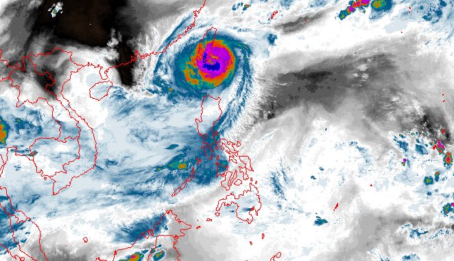
MANILA, Philippines – Typhoon Jenny (Koinu) again strengthened as it started passing over the area north of Batanes on Wednesday evening, October 4.
In its 11 pm bulletin on Wednesday, the Philippine Atmospheric, Geophysical, and Astronomical Services Administration (PAGASA) said Jenny’s maximum sustained winds increased from 155 kilometers per hour to 165 km/h, also the previous peak it reached.
The typhoon’s gustiness is now up to 205 km/h from the previous 190 km/h.
It was already 125 kilometers north of Itbayat, Batanes, still moving west at 15 km/h.
PAGASA warned that heavy rain from Jenny may persist in Batanes until Thursday, October 5. Floods and landslides are still possible in the province.
Tropical cyclone wind signals also remain raised in these areas as of 11 pm on Wednesday:
Signal No. 3
Storm-force winds (89 to 117 km/h), moderate to significant threat to life and property
- Batanes
Signal No. 2
Gale-force winds (62 to 88 km/h), minor to moderate threat to life and property
- northern part of Babuyan Islands (Babuyan Island, Calayan Island)
Signal No. 1
Strong winds (39 to 61 km/h), minimal to minor threat to life and property
- rest of Babuyan Islands
- northern part of mainland Cagayan (Santa Ana, Gonzaga, Buguey, Santa Teresita, Lal-lo, Camalaniugan, Pamplona, Claveria, Aparri, Ballesteros, Abulug, Allacapan, Sanchez Mira, Santa Praxedes, Lasam, Gattaran)
- northern part of Apayao (Calanasan, Pudtol, Luna, Santa Marcela, Flora)
- northern part of Ilocos Norte (Piddig, Bangui, Vintar, Burgos, Pagudpud, Bacarra, Adams, Pasuquin, Carasi, Dumalneg, Laoag City)
ALSO ON RAPPLER
- Bajo de Masinloc tragedy: Romualdez urges calm, lawmakers want more patrols
- Marcos lifts price cap on rice
- Brownlee saves day as Gilas Pilipinas stuns China in comeback win to reach Asian Games final
- Eumir Marcial KOs Syrian, advances to Asian Games final to punch Olympic ticket
- Nobel Chemistry prize awarded for discovery of quantum dots used in LED lights
Jenny is expected to make landfall in the southern part of Taiwan on Thursday morning. Taiwan is within the Philippine Area of Responsibility (PAR).
“Land interaction during its passage over the rugged terrain of southern Taiwan will weaken the typhoon considerably,” PAGASA said.
Then Jenny could leave PAR on Thursday afternoon or evening, emerging over the Taiwan Strait and eventually moving over the coastal waters of southeastern China. During this time, it may weaken further due to dry air.
By Sunday, October 8, Jenny could just be a tropical depression.

Meanwhile, Jenny is still enhancing the southwest monsoon or habagat, which is affecting western portions of Luzon. Rain due to the enhanced southwest monsoon is heaviest in the following provinces:
Wednesday night, October 4, to Thursday night, October 5
- 50-100 millimeters (mm): Zambales, Bataan, Occidental Mindoro, northern part of Palawan including Calamian, Cuyo, and Kalayaan islands
Thursday night, October 5, to Friday night, October 6
- 50-100 mm: Zambales, Bataan
Friday night, October 6, to Saturday night, October 7
- 50-100 mm: Pangasinan, Zambales, Bataan
Gusty conditions triggered by the enhanced southwest monsoon will also persist in the southern part of Aurora, Romblon, and parts of Calabarzon, Metro Manila, Bicol, and Bataan on Thursday.
For coastal waters, PAGASA released another gale warning at 5 pm on Wednesday, covering these seaboards:
- northern seaboard of Northern Luzon (Batanes, northern coast of Cagayan including Babuyan Islands) – rough to very high seas, waves 4.5 to 10.3 meters high, travel risky for all vessels
- eastern and western seaboards of Northern Luzon (Ilocos Norte, eastern coast of Cagayan, Isabela) – rough to very rough seas, waves 2.8 to 4.5 meters high, travel risky for small vessels
Jenny is the Philippines’ 10th tropical cyclone for 2023 and the second for September, having developed last Friday, September 29.
PAGASA expects four to seven tropical cyclones to form within or enter PAR from October 2023 to March 2024. For October alone, there may be two or three tropical cyclones. – Rappler.com
Add a comment
How does this make you feel?


There are no comments yet. Add your comment to start the conversation.