SUMMARY
This is AI generated summarization, which may have errors. For context, always refer to the full article.
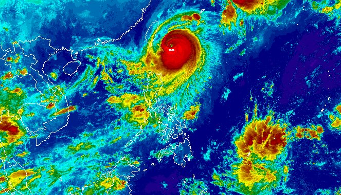
MANILA, Philippines – Typhoon Jenny (Koinu) slightly weakened and started turning west northwest toward the southern part of Taiwan early Wednesday, October 4.
Taiwan is within the Philippine Area of Responsibility (PAR).
Jenny was last spotted 270 kilometers east northeast of Itbayat, Batanes, moving west northwest at 10 kilometers per hour (km/h).
The typhoon’s maximum sustained winds slightly decreased from 155 km/h to 150 km/h, while its gustiness also eased from 190 km/h to 185 km/h.
The Philippine Atmospheric, Geophysical, and Astronomical Services Administration (PAGASA) updated the list of areas under tropical cyclone wind signals as of 5 am on Wednesday.
Signal No. 3
Storm-force winds (89 to 117 km/h), moderate to significant threat to life and property
- northern part of Batanes (Itbayat)
Signal No. 2
Gale-force winds (62 to 88 km/h), minor to moderate threat to life and property
- rest of Batanes
- northern part of Babuyan Islands (Babuyan Island, Calayan Island)
Signal No. 1
Strong winds (39 to 61 km/h), minimal to minor threat to life and property
- rest of Babuyan Islands
- northern part of mainland Cagayan (Santa Ana, Gonzaga, Buguey, Santa Teresita, Lal-lo, Camalaniugan, Pamplona, Claveria, Aparri, Ballesteros, Abulug, Allacapan, Sanchez Mira, Santa Praxedes, Lasam, Gattaran)
- northern part of Apayao (Calanasan, Pudtol, Luna, Santa Marcela, Flora)
- northern part of Ilocos Norte (Piddig, Bangui, Vintar, Burgos, Pagudpud, Bacarra, Adams, Pasuquin, Carasi, Dumalneg, Laoag City)
Jenny is not expected to make landfall in the Philippines, but it continues to trigger rain in extreme Northern Luzon. Floods and landslides are still possible.
Wednesday, October 4
- 100-200 millimeters (mm): Batanes
- 50-100 mm: northern part of Babuyan Islands
Thursday, October 5
- 50-100 mm: Batanes, northern part of Babuyan Islands
ALSO ON RAPPLER
- Analysts point to inflation, rice promise after Marcos, Duterte approval scores plunge
- PH earns Asian Games sepak takraw bronze, snaps 33-year drought
- PH athletics quartet sets new national record in Asiad 4×400 relay
- Too easy: Uzbek world champion toys with Carlo Paalam on way to Asiad semifinals
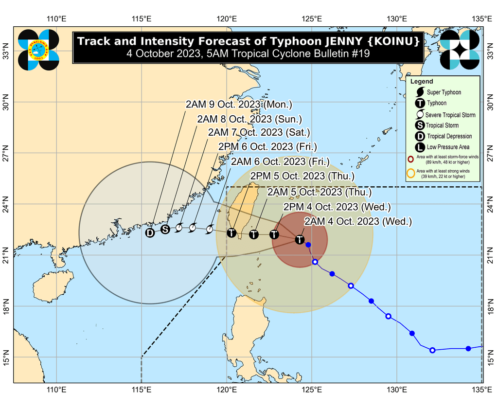
Jenny is projected to keep moving west northwest until Wednesday afternoon, then west.
The typhoon could make landfall in the southern part of Taiwan on Thursday morning, October 5, then exit PAR on Thursday afternoon or evening.
Outside PAR, it will keep moving west over the Taiwan Strait and the coastal waters of southeastern China.
PAGASA also expects Jenny to weaken further due to interaction with dry air and once it hits Taiwan’s rugged terrain.
Jenny is still enhancing the southwest monsoon or habagat as well. Rain from the enhanced southwest monsoon will persist in these areas:
Tuesday night, October 3, to Wednesday night, October 4
- 50-100 mm: Zambales, Bataan, Occidental Mindoro, northern part of Palawan including Calamian, Cuyo, and Kalayaan islands
Wednesday night, October 4, to Thursday night, October 5
- 50-100 mm: Zambales, Bataan, Pampanga, Bulacan, Metro Manila, Cavite, Batangas, Occidental Mindoro
Thursday night, October 5, to Friday night, October 6
- 50-100 mm: La Union, Pangasinan, Zambales, Bataan, Occidental Mindoro
The enhanced southwest monsoon is also causing gusty conditions in the following areas:
Wednesday, October 4
- southern part of Aurora, Bataan, Metro Manila, Occidental Mindoro, Kalayaan Islands, Romblon, most of Calabarzon, parts of Bicol
Thursday, October 5
- southern part of Aurora, Romblon, parts of Calabarzon, parts of Bicol
For coastal waters, PAGASA issued a new gale warning at 5 am on Wednesday, covering these seaboards:
- northern seaboard of Northern Luzon (Batanes, northern coast of Cagayan including Babuyan Islands) – rough to very high seas, waves 4.5 to 10.3 meters high, travel risky for all vessels
- eastern and western seaboards of Northern Luzon (Ilocos Norte, eastern coast of Cagayan, Isabela) – rough to very rough seas, waves 2.8 to 4.5 meters high, travel risky for small vessels
The typhoon is also causing moderate to rough seas in the coastal waters of northern Aurora, with waves 1.5 to 3 meters high. The weather bureau advised small vessels to take precautionary measures or avoid sailing, if possible.
Jenny is the Philippines’ 10th tropical cyclone for 2023 and the second for September, having developed last Friday, September 29.
PAGASA expects four to seven tropical cyclones to form within or enter PAR from October 2023 to March 2024. For October alone, there may be two or three tropical cyclones. – Rappler.com
Add a comment
How does this make you feel?


There are no comments yet. Add your comment to start the conversation.