SUMMARY
This is AI generated summarization, which may have errors. For context, always refer to the full article.
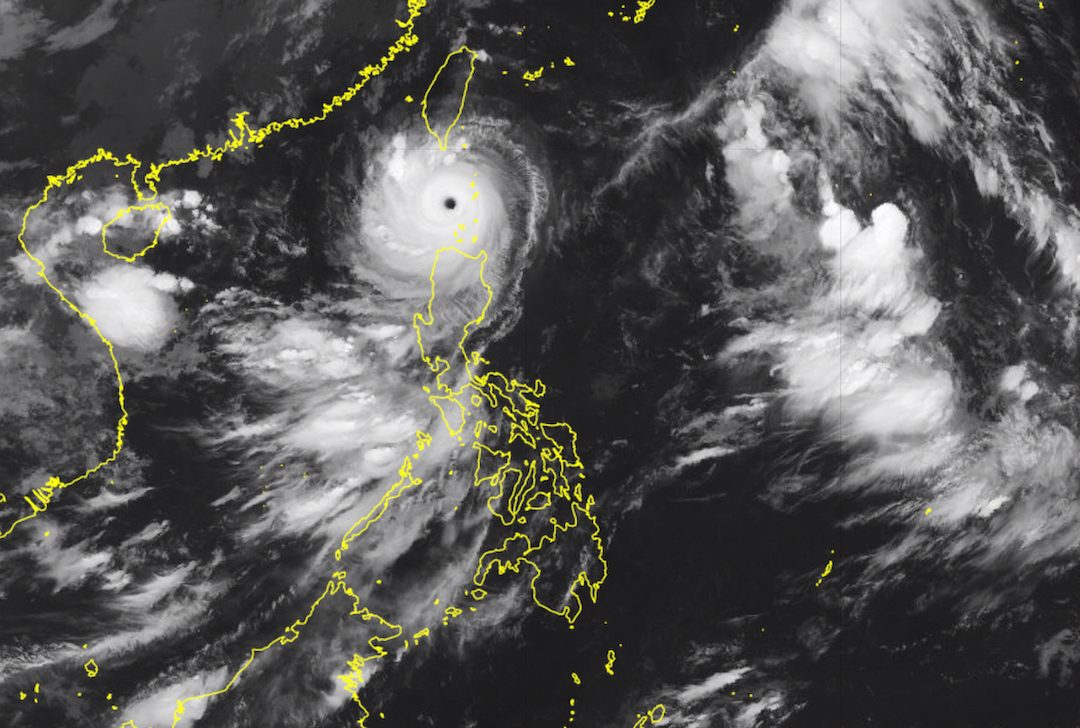
MANILA, Philippines – Super Typhoon Goring (Saola) left the Balintang Channel and started moving toward the northern part of the West Philippine Sea early Wednesday morning, August 30.
Goring was already 90 kilometers west southwest of Basco, Batanes, at 7 am on Wednesday. The super typhoon is moving west northwest at a slightly slower 15 kilometers per hour from the previous 20 km/h.
It is seen to move northwest or west northwest until it leaves the Philippine Area of Responsibility (PAR) on Wednesday night or Thursday morning, August 31.
Goring also maintained its strength early Wednesday morning, with maximum sustained winds of 195 km/h and gustiness of up to 240 km/h.
It is likely to remain a super typhoon until Friday, September 1, said the Philippine Atmospheric, Geophysical, and Astronomical Services Administration (PAGASA) in its 8 am bulletin on Wednesday.
Goring did not make landfall, but has been bringing heavy to torrential rain and fierce winds to parts of Northern Luzon.

With Goring already heading for the West Philippine Sea, Signal No. 4 has also been lifted. Below are the areas still under tropical cyclone wind signals as of 8 am on Wednesday.
Signal No. 3
Storm-force winds (89 to 117 km/h), moderate to significant threat to life and property
- Batanes
- northern and western parts of Babuyan Islands (Babuyan Island, Calayan Island, Dalupiri Island)
Signal No. 2
Gale-force winds (62 to 88 km/h), minor to moderate threat to life and property
- rest of Babuyan Islands
- northern part of Ilocos Norte (Pagudpud, Adams, Bangui, Dumalneg, Burgos)
- extreme northwestern part of mainland Cagayan (Santa Praxedes, Sanchez Mira, Claveria, Pamplona, Abulug)
Signal No. 1
Strong winds (39 to 61 km/h), minimal to minor threat to life and property
- northern and central parts of Cagayan (Solana, Tuao, Iguig, Amulung, Santo Niño, Piat, Rizal, Lasam, Gattaran, Santa Ana, Gonzaga, Lal-lo, Santa Teresita, Buguey, Baggao, Alcala, Camalaniugan, Aparri, Allacapan, Ballesteros)
- Apayao
- northern part of Kalinga (Balbalan, Pinukpuk)
- northern part of Abra (Tineg, Lagayan, Lacub, Malibcong, San Juan, Danglas, La Paz, Dolores, Bangued, Lagangilang, Licuan-Baay)
- rest of Ilocos Norte
- extreme northern part of Ilocos Sur (Sinait, Cabugao, San Juan, Magsingal)
PAGASA maintained its rainfall forecast for Goring, however, as the super typhoon continues to trigger heavy to torrential rain in these areas on Wednesday:
- Greater than 200 mm: southern part of Batanes, northwestern part of Babuyan Islands
- 100-200 mm: Ilocos Norte, northern part of Apayao, extreme northwestern part of mainland Cagayan, rest of Batanes, rest of Babuyan Islands
- 50-100 mm: Ilocos Sur, Abra, rest of Apayao, northwestern part of mainland Cagayan
There may be more floods and landslides.
The weather bureau also warned of a “moderate to high risk” of storm surges, “which may cause flooding in the low-lying and exposed coastal areas of Batanes and the northern and western portions of Babuyan Islands.”
ALSO ON RAPPLER
- Makati starts marking city-owned properties in EMBO schools
- How diplomats who traffick, exploit domestic workers get away
- United front: Ravena hopes for full fan support as Gilas Pilipinas eyes strong FIBA World Cup finish
- Not the time to blame: Abando defends Chot Reyes amid boos
In addition, Goring continues to enhance the southwest monsoon or habagat, which is causing rain in the western parts of Luzon and the Visayas, particularly these areas:
Tuesday evening, August 29, to Wednesday evening, August 30
- 100-200 mm: northern part of Palawan including Calamian and Cuyo islands, Occidental Mindoro
- 50-100 mm: southern part of Palawan including Cagayancillo, Zambales, Bataan, Antique, Negros Occidental, Guimaras
Wednesday evening, August 30, to Thursday evening, August 31
- 100-200 mm: Occidental Mindoro
- 50-100 mm: Zambales, Bataan, Metro Manila, Bulacan, Cavite, Batangas, northern part of Palawan including Calamian and Cuyo islands
Thursday evening, August 31, to Friday evening, September 1
- 100-200 mm: Zambales, Bataan, Occidental Mindoro
- 50-100 mm: Metro Manila, Rizal, Bulacan, Cavite, Batangas, Pangasinan, northern part of Palawan including Calamian and Cuyo islands
The enhanced southwest monsoon is triggering gusty conditions in these areas as well:
Wednesday, August 30
- Ilocos Region, Cordillera Administrative Region, Zambales, Bataan, Bulacan, Aurora, Metro Manila, Calabarzon, Mimaropa, Bicol, Western Visayas
Thursday, August 31, and Friday, September 1
- Ilocos Region, Cordillera Administrative Region, Zambales, Bataan, Bulacan, Pampanga, Aurora, Metro Manila, Calabarzon, Mimaropa, Bicol, Western Visayas

For coastal waters, the gale warning released at 5 am on Wednesday – due to both Goring and the enhanced southwest monsoon – is still in effect:
- northern seaboard of Northern Luzon (Batanes, northern coast of Ilocos Norte, northern coast of Cagayan including Babuyan Islands) – rough to high seas, with waves 3.1 to 7.5 meters high
- western seaboard of Luzon (western coast of Ilocos Norte, Ilocos Sur, La Union, Pangasinan, Zambales, Bataan, Occidental Mindoro) – rough to very rough seas, with waves 2.8 to 4.5 meters high
- western and southern seaboards of Southern Luzon, western seaboard of Visayas (Metro Manila, Cavite, Batangas, Oriental Mindoro, Marinduque, Romblon, Palawan, Aklan, Antique, Capiz, Iloilo, Guimaras, Negros Occidental) – rough to very rough seas, with waves 2.8 to 4.5 meters high
- eastern seaboard of Philippines, central seaboard of Visayas (eastern seaboard of Cagayan, Isabela, Aurora, northern Quezon, southern Quezon, Camarines Norte, Camarines Sur, Catanduanes, Albay, Sorsogon, Masbate, Negros Oriental, Cebu, Bohol, Siquijor, Northern Samar, Eastern Samar, Samar, Biliran, Leyte, Southern Leyte, Dinagat Islands) – rough to very rough seas, with waves 2.8 to 4.5 meters high
The weather bureau advised fishing boats and other small vessels not to sail, and larger vessels to watch out for big waves.
After Goring’s expected exit from PAR on Wednesday night or Thursday morning, it is projected to head west northwest for the rest of Thursday before shifting toward the west on Friday, then west southwest on Sunday, September 3.
It may move “nearly parallel to the coast of Guangdong, China,” but PAGASA said landfall is possible in mainland China on Sunday.
“Increasingly unfavorable conditions over the waters off the coast of Guangdong will trigger a weakening trend and by Monday (September 4), Goring will have weakened into a severe tropical storm,” added the weather bureau.
Goring is the Philippines’ seventh tropical cyclone for 2023 and the first for August. It is also the third super typhoon for the year, after Betty (Mawar) in May and Egay (Doksuri) in July.
PAGASA previously said it expects two or three tropical cyclones to develop within or enter PAR in August.
The second tropical cyclone for August could enter PAR on Wednesday – Severe Tropical Storm Haikui, to be locally named Hanna.
Haikui was located 1,560 kilometers east of extreme Northern Luzon at 3 am on Wednesday, still moving west northwest at 15 km/h.
It maintained its strength, with maximum sustained winds of 110 km/h and gustiness of up to 135 km/h.
Haikui is seen to remain far from Philippine landmass, which means it is “less likely to directly affect the country.”

But Haikui or the potential Hanna will keep intensifying. It may become a typhoon by Wednesday morning, then reach its peak intensity on Friday evening.
Starting Wednesday or Thursday, it could enhance the southwest monsoon, which may lead to more monsoon rain in the western parts of Luzon and the Visayas.
Haikui is expected to exit PAR on Friday morning, while approaching Japan’s Ryukyu Islands. Outside PAR, it may turn northwest or north over the East China Sea. – Rappler.com
Add a comment
How does this make you feel?


There are no comments yet. Add your comment to start the conversation.