SUMMARY
This is AI generated summarization, which may have errors. For context, always refer to the full article.
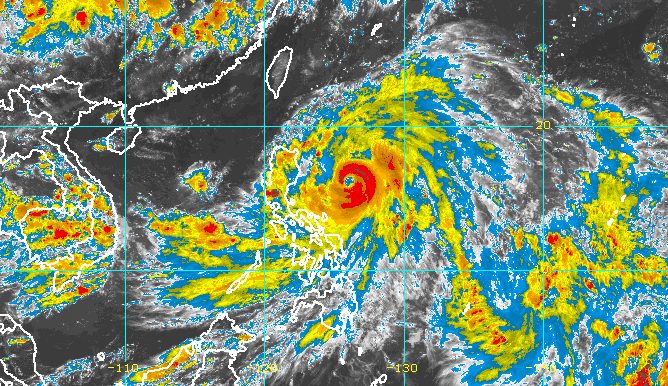
MANILA, Philippines – Typhoon Egay (Doksuri) continued to gain strength on Monday afternoon, July 24, while maintaining its generally slow pace over the Philippine Sea.
In a briefing past 5 pm on Monday, the Philippine Atmospheric, Geophysical, and Astronomical Services Administration (PAGASA) said Egay’s maximum sustained winds increased from 150 kilometers per hour to 155 km/h.
The typhoon’s gustiness is now up to 190 km/h from the previous 185 km/h.
Egay was last spotted 500 kilometers east of Baler, Aurora, heading north northwest at only 10 km/h. It was previously moving west.
The typhoon is projected to maintain its north northwest direction in the next 12 hours or until early Tuesday, July 25. Then it could turn northwest, heading closer to Northern Luzon and crossing the Luzon Strait.
Egay is seen to make landfall in or pass very close to the Babuyan Islands-Batanes area between late Tuesday evening and Wednesday morning, July 26.
But PAGASA reiterated that it is not ruling out landfall in the northeastern part of mainland Cagayan if Egay’s track shifts further, closer to Luzon. The typhoon’s movement is being influenced by the ridge of a high pressure area above it.
Egay is also on track to becoming a super typhoon by late Tuesday or early Wednesday. But if its track shifts closer to Luzon landmass, it may “peak at an intensity just below super typhoon threshold,” or just below 185 km/h.
“Nevertheless, Egay is forecast to become a very strong typhoon,” added PAGASA.
Here are the areas under tropical cyclone wind signals as of 5 pm on Monday:
Signal No. 2
Gale-force winds (62 to 88 km/h), minor to moderate threat to life and property
- Catanduanes
- eastern part of Albay (Rapu-Rapu, Bacacay, Tabaco City, Malilipot, Malinao, Tiwi)
- northern part of Camarines Norte (Calaguas and Maculabo Islands)
- eastern part of Camarines Sur (Caramoan, Presentacion, Garchitorena, Lagonoy, San Jose, Sagñay)
- Isabela
- northern and central parts of Aurora (Dilasag, Casiguran, Dinalungan, Dipaculao)
- Quirino
- Cagayan including Babuyan Islands
- Apayao
- Kalinga
- central and eastern parts of Mountain Province (Paracelis, Natonin, Barlig, Sadanga, Bontoc)
- eastern part of Nueva Vizcaya (Kasibu, Quezon, Diadi, Bagabag)
- eastern part of Ifugao (Alfonso Lista, Aguinaldo, Mayoyao, Lagawe, Banaue, Hingyon, Lamut)
- central and eastern parts of Abra (Tineg, Lacub, Malibcong, Lagangilang, San Juan, Dolores, Lagayan, Danglas, La Paz, Daguioman, Boliney, Bucloc, Licuan-Baay, Sallapadan, Tayum, Bucay, Bangued, Peñarrubia, Manabo, Tubo)
- Ilocos Norte
- Batanes
- northeastern part of Northern Samar (Laoang, Palapag)
Signal No. 1
Strong winds (39 to 61 km/h), minimal to minor threat to life and property
- Sorsogon
- rest of Albay
- rest of Camarines Sur
- rest of Camarines Norte
- rest of Abra
- rest of Mountain Province
- rest of Ifugao
- rest of Nueva Vizcaya
- Quezon including Polillo Islands
- rest of Aurora
- Benguet
- Ilocos Sur
- La Union
- Pangasinan
- Nueva Ecija
- Tarlac
- Zambales
- Bataan
- Bulacan
- Pampanga
- Metro Manila
- Rizal
- Cavite
- Laguna
- Marinduque
- central and eastern parts of Romblon (Banton, Corcuera, Romblon, Magdiwang, Cajidiocan, San Fernando)
- northern and central parts of Batangas (Calaca, Cuenca, Taysan, Lian, Tuy, Balayan, Talisay, Padre Garcia, Agoncillo, Santo Tomas, San Jose, Lemery, Lipa City, Ibaan, Tanauan City, Mataasnakahoy, Alitagtag, Balete, Nasugbu, San Juan, San Nicolas, Rosario, Laurel, Santa Teresita, Taal, Malvar)
- Eastern Samar
- rest of Northern Samar
- Samar
- Biliran
- northern and central parts of Leyte (Tunga, Pastrana, San Miguel, Mahaplag, Matag-ob, Tolosa, Palo, Calubian, Leyte, Mayorga, Julita, Carigara, Babatngon, Dagami, Jaro, Abuyog, San Isidro, Santa Fe, Albuera, Villaba, La Paz, Palompon, MacArthur, Tabontabon, Tanauan, Merida, Ormoc City, Isabel, Javier, Dulag, Capoocan, Alangalang, Baybay City, Burauen, Tabango, Tacloban City, Kananga, Barugo)
- northern part of Cebu (Daanbantayan, Medellin) including Bantayan Islands and Camotes Islands
The highest possible wind signal is either Signal No. 4 or 5.
PAGASA also warned that Egay is bringing rain to parts of Luzon until Thursday, July 27, with floods and landslides highly likely.
Monday afternoon, July 24, to Tuesday afternoon, July 25
- 50-100 millimeters (mm): Cagayan, Catanduanes, Camarines Sur, Camarines Norte, Albay, Sorsogon
Tuesday afternoon, July 25, to Wednesday afternoon, July 26
- Above 200 mm: Batanes, Cagayan, Ilocos Norte, Ilocos Sur, Apayao, Abra, northern part of La Union
- 100-200 mm: northern and eastern parts of Isabela, rest of La Union, Mountain Province, Benguet, western part of Pangasinan
- 50-100 mm: rest of Cordillera Administrative Region, rest of Pangasinan, Zambales
Wednesday afternoon, July 26, to Thursday evening, July 27
- Above 200 mm: Batanes, Babuyan Islands, Ilocos Norte, northwestern part of Abra
- 100-200 mm: northern part of mainland Cagayan, Apayao, rest of Abra, Ilocos Sur
- 50-100 mm: rest of mainland Cagayan, Kalinga, western part of Mountain Province, Benguet, La Union, Pangasinan
In addition, PAGASA said there is a minimal to moderate risk of storm surges up to 3 meters high which may cause floods in low-lying and exposed coastal areas of the following provinces:
- Batanes
- Cagayan
- Ilocos Norte
- Ilocos Sur
- Isabela

For coastal waters, the weather bureau released a new gale warning at 5 pm on Monday due to both Egay and the southwest monsoon or habagat. Rough to very rough seas are expected in these seaboards:
- seaboards of Northern Luzon, eastern seaboards of Central Luzon and Southern Luzon, eastern seaboard of Visayas (Ilocos Norte, Batanes, Cagayan including Babuyan Islands, Isabela, Aurora, Catanduanes, eastern coast of Camarines Sur, eastern coast of Albay, Northern Samar) – waves 3.1 to 6 meters high
- seaboards of Southern Luzon, eastern and central seaboards of Visayas (Camarines Norte, Quezon including Polillo Islands, rest of Camarines Sur, rest of Albay, Sorsogon, Masbate including Ticao and Burias islands, Marinduque, Romblon, Eastern Samar, Samar, Biliran, Leyte, northern coast of Cebu) – waves 3.1 to 6 meters high
- western seaboard of Southern Luzon, seaboards of Central Visayas and Western Visayas (Bohol, rest of Cebu, Negros Oriental, Negros Occidental, Guimaras, Iloilo, Capiz, Aklan, Antique, Occidental Mindoro, Palawan including Calamian, Cuyo, and Kalayaan Islands) – waves 2.8 to 4.5 meters high
- eastern seaboard of Mindanao (eastern coast of Surigao del Norte including Siargao and Bucas Grande islands, Dinagat Islands) – waves 2.8 to 4.5 meters high
“Sea travel is risky for small seacraft. For larger vessels, operating in gale conditions requires experience and properly equipped vessels. Mariners without proper experience or operating ill-equipped vessels are advised to remain in port or seek safe harbor,” PAGASA said.
The typhoon might also cause moderate to rough seas in the western and southern seaboards of Southern Luzon, the remaining seaboards of the Visayas, and the eastern seaboard of Mindanao not covered by the gale warning. Small vessels should take precautionary measures as waves may be 2 to 3 meters high.
Meanwhile, Egay is still enhancing the southwest monsoon, which is affecting the Visayas, Mindanao, and the western part of Southern Luzon. Rain may be heaviest in the following areas:
Monday, July 24
- 50-100 mm: Occidental Mindoro, northern part of Palawan including Cuyo, Calamian, and Kalayaan Islands, Antique, Iloilo, Guimaras, Negros Occidental
Tuesday, July 25
- 50-100 mm: Bataan, Occidental Mindoro, Antique, northern part of Palawan including Cuyo, Calamian, Kalayaan, and Cagayancillo Islands
Wednesday, July 26
- 50-100 mm: Metro Manila, Cavite, Batangas, Occidental Mindoro, Antique, northern part of Palawan including Cuyo, Calamian, and Kalayaan Islands
Floods and landslides are possible in areas affected by the enhanced southwest monsoon.
The enhanced southwest monsoon may also bring gusty conditions to these areas not under any tropical cyclone wind signal:
Monday, July 24
- rest of Visayas, rest of Mimaropa, and northern parts of Zamboanga Peninsula, Northern Mindanao, and Caraga
Tuesday, July 25
- rest of Luzon, rest of Visayas, Zamboanga Peninsula, Basilan, Sulu, Tawi-Tawi, northern part of Northern Mindanao, Dinagat Islands
Wednesday, July 26
- Visayas, rest of Luzon
Egay may leave the Philippine Area of Responsibility (PAR) on Thursday. Then it would cross the Taiwan Strait and make landfall in Fujian, China, late Thursday or early Friday, July 28.
Before Egay leaves PAR, it might start to weaken on Wednesday afternoon or evening “as it enters the cooler waters southwest and west of Taiwan.” Taiwan is within PAR.
Egay is the Philippines’ fifth tropical cyclone for 2023 and the second for July. PAGASA earlier estimated that two to four tropical cyclones would form inside or enter PAR during the month. – Rappler.com
Add a comment
How does this make you feel?


There are no comments yet. Add your comment to start the conversation.