SUMMARY
This is AI generated summarization, which may have errors. For context, always refer to the full article.
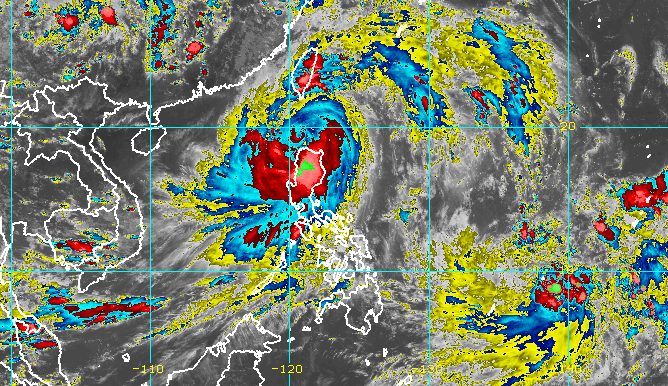
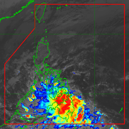
MANILA, Philippines – Typhoon Egay (Doksuri) was slowly moving away from Dalupiri Island in Calayan, Cagayan, late Wednesday afternoon, July 26, but it continued to trigger intense rain and fierce winds.
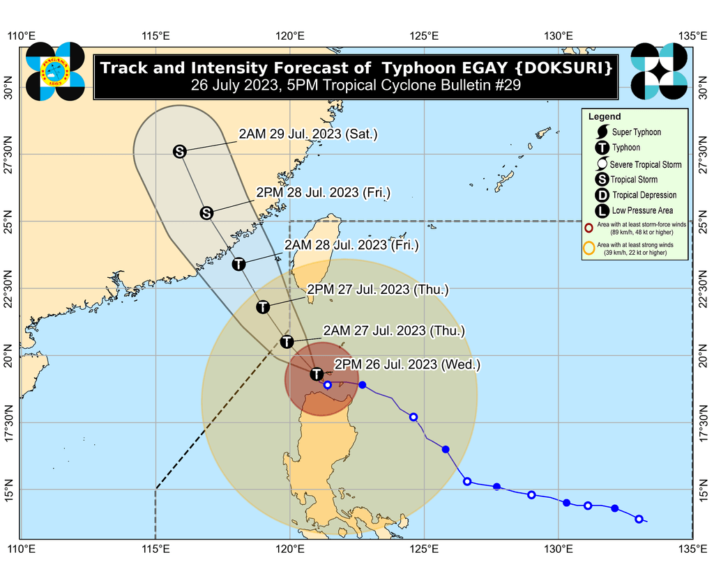
Earlier, Egay made its second landfall in Dalupiri Island at 9:30 am on Wednesday. Its first landfall was in Fuga Island in Aparri, also in Cagayan, at 3:10 am.
As of 4 pm on Wednesday, the typhoon was already 70 kilometers west northwest of the municipality of Calayan, moving northwest at only 10 kilometers per hour (km/h).
Egay continues to have maximum sustained winds of 175 km/h and gustiness of up to 240 km/h. At its peak, it was a super typhoon.
In the coming hours, Egay could move northwest or north northwest and pass over the waters south and southwest of Taiwan, said the Philippine Atmospheric, Geophysical, and Astronomical Services Administration (PAGASA). Taiwan is within the Philippine Area of Responsibility (PAR).
The typhoon is expected to leave PAR on Thursday morning, July 27.
But for now, tropical cyclone wind signals remain in effect in the following areas as of 5 pm on Wednesday:
Signal No. 4
Typhoon-force winds (118 to 184 km/h), significant to severe threat to life and property
- northwestern part of Cagayan (Claveria, Sanchez Mira, Pamplona, Abulug, Ballesteros, Santa Praxedes) including Babuyan Islands
- northern part of Ilocos Norte (Burgos, Bangui, Dumalneg, Pagudpud, Adams)
Signal No. 3
Storm-force winds (89 to 117 km/h), moderate to significant threat to life and property
- Batanes
- northern and central parts of Cagayan (Gattaran, Lal-lo, Alcala, Allacapan, Lasam, Baggao, Amulung, Rizal, Santo Niño, Piat, Santa Ana, Gonzaga, Santa Teresita, Buguey, Camalaniugan, Aparri)
- rest of Ilocos Norte
- Apayao
- northern part of Abra (Tineg, Lagayan, Lacub, Danglas, San Juan)
- northern part of Ilocos Sur (Cabugao, Sinait)
Signal No. 2
Gale-force winds (62 to 88 km/h), minor to moderate threat to life and property
- Kalinga
- Mountain Province
- Ifugao
- Isabela
- rest of Cagayan
- rest of Ilocos Sur
- rest of Abra
- northern and central parts of La Union (Luna, Caba, Santol, Bauang, San Fernando City, San Juan, Bagulin, Bangar, San Gabriel, Burgos, Naguilian, Bacnotan, Sudipen, Balaoan, Aringay)
- northern and central parts of Benguet (Mankayan, Kapangan, Atok, Kabayan, Kibungan, La Trinidad, Sablan, Bakun, Buguias, Tublay, Bokod)
Signal No. 1
Strong winds (39 to 61 km/h), minimal to minor threat to life and property
- Quirino
- Nueva Vizcaya
- rest of La Union
- rest of Benguet
- Aurora
- Pangasinan
- Nueva Ecija
- Tarlac
- Zambales
- Bataan
- Bulacan
- Pampanga
- Metro Manila
- Cavite
- Rizal
- Laguna
- northern part of Quezon (Infanta, General Nakar, Real, Lucban, Sampaloc, Mauban) including Polillo Islands
“Violent, life-threatening conditions are expected to continue over Babuyan Islands, the northwestern portion of mainland Cagayan, and the northern portions of Apayao and Ilocos Norte in the next 6 hours,” PAGASA warned.
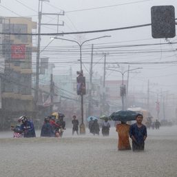
Egay is also bringing more rain to Northern Luzon, so affected provinces must continue to watch out for floods and landslides. Below is PAGASA’s updated rainfall forecast for the rest of Wednesday until Thursday afternoon.
- Above 200 millimeters (mm): northwestern part of Cagayan including Babuyan Islands, Ilocos Norte
- 100-200 mm: Batanes, Ilocos Sur, rest of Cagayan, Apayao, Abra
- 50-100 mm: Zambales, rest of Cordillera Administrative Region, rest of Ilocos Region
There is still a high risk of storm surges which may cause floods in the low-lying and exposed coastal areas of the following provinces:
- Batanes
- Cagayan including Babuyan Islands
- portions of Isabela
- Ilocos Norte
- portions of Ilocos Sur
“Maximum surge heights may exceed 3 meters in most of the warning areas,” PAGASA said.
For coastal waters, the weather bureau issued another gale warning at 5 pm on Wednesday, covering these seaboards:
- seaboards of Northern Luzon (Ilocos Norte, Ilocos Sur, La Union, Batanes, Cagayan including Babuyan Islands, Isabela) – rough to very high, with waves 3.7 to 12.1 meters high
- eastern seaboard of Central Luzon (Pangasinan, Aurora) – rough to very rough, with waves 3.1 to 6 meters high
- western seaboards of Central Luzon and Southern Luzon, western seaboard of Visayas (Zambales, Bataan, Occidental Mindoro, Palawan including Kalayaan, Calamian, Cuyo, and Cagayancillo islands, Negros Occidental, Guimaras, Iloilo, Capiz, Aklan, Antique) – rough to very rough, with waves 2.8 to 4.5 meters high
- southern and eastern seaboards of Southern Luzon (Metro Manila, Cavite, Batangas, Marinduque, Romblon, Masbate including Ticao and Burias islands, Quezon including Polillo Islands, Camarines Norte, Camarines Sur, Catanduanes, Albay, Sorsogon) – rough to very rough, with waves 2.8 to 4.5 meters high
- central and eastern seaboards of Visayas (Northern Samar, Eastern Samar, Samar, Biliran, Bohol, Cebu, Negros Oriental, Siquijor) – rough to very rough, with waves 2.8 to 4.5 meters high
Travel is risky for all vessels in areas with rough to very high seas, while travel is risky for small vessels in rough to very rough seas.
Meanwhile, Egay is still enhancing the southwest monsoon or habagat, which has also been dumping rain. These areas are most affected by the enhanced southwest monsoon, and must stay on alert for floods and landslides:
Wednesday, July 26
- 100-200 mm: Occidental Mindoro
- 50-100 mm: Western Visayas, northern part of Palawan including Cuyo, Calamian, and Kalayaan islands, Antique
Thursday, July 27
- 100-200 mm: Occidental Mindoro
- 50-100 mm: Pangasinan, Zambales, Bataan, Batangas, northern part of Palawan including Cuyo, Calamian, Kalayaan, and Cagayancillo islands
Friday, July 28
- 50-100 mm: La Union, Pangasinan, Zambales, Bataan, Occidental Mindoro, northern part of Palawan including Cuyo, Calamian, and Kalayaan islands
Gusty conditions, still due to the enhanced southwest monsoon, may persist in these areas as well:
Wednesday, July 26
- Luzon, Visayas
Thursday, July 27
- Luzon, Western Visayas
Friday, July 28
- Batanes, Ilocos Region, Zambales, Bataan, Cavite, southern part of Quezon, Mimaropa, Bicol, Western Visayas
PAGASA added that the enhanced southwest monsoon will cause moderate to rough seas in the coastal waters of Mindanao. Small vessels should take precautionary measures as waves may be 2 to 3 meters high.
Once Egay leaves PAR, it is projected to cross the Taiwan Strait and make landfall in Fujian, China, on Friday morning, July 28.
PAGASA also said Egay may weaken, “although the rate of weakening will not be rapid due to [a] slightly favorable environment offsetting the impact of land interaction with the rugged terrain of Northern Luzon and Taiwan.”
But once Egay makes landfall in Fujian and moves inland over mainland China, “a more rapid weakening is expected,” added the weather bureau. The tropical cyclone might degenerate into a remnant low by Saturday, July 29.
Egay is the Philippines’ fifth tropical cyclone for 2023 and the second for July. PAGASA earlier estimated that two to four tropical cyclones would form inside or enter PAR during the month.
The weather bureau said on Wednesday that it is monitoring a new low pressure area (LPA) located outside PAR.
The LPA was last spotted 1,615 kilometers east of northeastern Mindanao on Wednesday afternoon.
PAGASA advised the public to monitor updates on the LPA in the coming days. – Rappler.com
Add a comment
How does this make you feel?


There are no comments yet. Add your comment to start the conversation.