SUMMARY
This is AI generated summarization, which may have errors. For context, always refer to the full article.
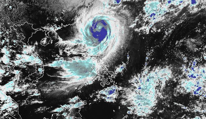
MANILA, Philippines – Typhoon Jenny (Koinu) slightly intensified as it continued to head for Taiwan on Wednesday afternoon, October 4.
The typhoon’s maximum sustained winds were back to 155 kilometers per hour from 150 km/h, said the Philippine Atmospheric, Geophysical, and Astronomical Services Administration (PAGASA) in its 5 pm bulletin on Wednesday.
Jenny’s gustiness is now up to 190 km/h from 185 km/h.
As of 4 pm, the typhoon was located 155 kilometers north northeast of Itbayat, Batanes, moving west at 15 km/h.
The following areas remain under tropical cyclone wind signals as of 5 pm on Wednesday:
Signal No. 3
Storm-force winds (89 to 117 km/h), moderate to significant threat to life and property
- northern part of Batanes (Itbayat)
Signal No. 2
Gale-force winds (62 to 88 km/h), minor to moderate threat to life and property
- rest of Batanes
- northern part of Babuyan Islands (Babuyan Island, Calayan Island)
Signal No. 1
Strong winds (39 to 61 km/h), minimal to minor threat to life and property
- rest of Babuyan Islands
- northern part of mainland Cagayan (Santa Ana, Gonzaga, Buguey, Santa Teresita, Lal-lo, Camalaniugan, Pamplona, Claveria, Aparri, Ballesteros, Abulug, Allacapan, Sanchez Mira, Santa Praxedes, Lasam, Gattaran)
- northern part of Apayao (Calanasan, Pudtol, Luna, Santa Marcela, Flora)
- northern part of Ilocos Norte (Piddig, Bangui, Vintar, Burgos, Pagudpud, Bacarra, Adams, Pasuquin, Carasi, Dumalneg, Laoag City)
PAGASA also maintained its rainfall forecast for Jenny, which is still bringing rain to extreme Northern Luzon.
Wednesday afternoon, October 4, to Thursday afternoon, October 5
- 100-200 millimeters (mm): Batanes
- 50-100 mm: northern part of Babuyan Islands
Thursday afternoon, October 5, to Friday afternoon, October 6
- 50-100 mm: Batanes, northern part of Babuyan Islands
ALSO ON RAPPLER
- 3 Filipino fishermen dead as foreign vessel rams boat off Bajo de Masinloc
- LIVE UPDATES: Philippines vs China – 19th Asian Games basketball semifinal
- How Maggie Wilson’s disinformation battle helped expose paid propagandists
- #HoldTheLine: Maria Ressa talks to singer-songwriter Jewel
- Business Sense: LinkedIn’s Atul Harkisanka on AI and jobs
The weather bureau expects Jenny to keep moving west en route to the southern part of Taiwan, where it will make landfall on Thursday morning, October 5. Taiwan is within the Philippine Area of Responsibility (PAR).
Afterwards, the typhoon is projected to exit PAR on Thursday afternoon or evening.
Outside PAR, it will continue to move west over the Taiwan Strait and the coastal waters of southeastern China.
PAGASA also said Jenny may weaken due to interaction with dry air and once it hits Taiwan’s rugged terrain.

Meanwhile, rain from the southwest monsoon or habagat, which is still being enhanced by Jenny, will persist in these provinces:
Wednesday, October 4
- 50-100 mm: Zambales, Bataan, Occidental Mindoro, northern part of Palawan including Calamian, Cuyo, and Kalayaan islands
Thursday, October 5
- 50-100 mm: Zambales, Bataan, Cavite, Batangas, Occidental Mindoro
Friday, October 6
- 50-100 mm: La Union, Pangasinan, Zambales, Bataan, Occidental Mindoro
The enhanced southwest monsoon is also causing gusty conditions in the following areas:
Wednesday, October 4
- southern part of Aurora, Bataan, Metro Manila, Occidental Mindoro, Kalayaan Islands, Romblon, most of Calabarzon, parts of Bicol
Thursday, October 5
- southern part of Aurora, Romblon, parts of Calabarzon, parts of Bicol
For coastal waters, PAGASA released another gale warning at 5 pm on Wednesday, covering these seaboards:
- northern seaboard of Northern Luzon (Batanes, northern coast of Cagayan including Babuyan Islands) – rough to very high seas, waves 4.5 to 10.3 meters high, travel risky for all vessels
- eastern and western seaboards of Northern Luzon (Ilocos Norte, eastern coast of Cagayan, Isabela) – rough to very rough seas, waves 2.8 to 4.5 meters high, travel risky for small vessels
The typhoon is also causing moderate to rough seas in the coastal waters of northern Aurora, with waves 1.5 to 3 meters high. The weather bureau advised small vessels to take precautionary measures or avoid sailing, if possible.
Jenny is the Philippines’ 10th tropical cyclone for 2023 and the second for September, having developed last Friday, September 29.
PAGASA expects four to seven tropical cyclones to form within or enter PAR from October 2023 to March 2024. For October alone, there may be two or three tropical cyclones. – Rappler.com
Add a comment
How does this make you feel?


There are no comments yet. Add your comment to start the conversation.