SUMMARY
This is AI generated summarization, which may have errors. For context, always refer to the full article.
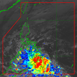
MANILA, Philippines – Typhoon Egay (Doksuri) continued to move away from the Philippine Area of Responsibility (PAR) on Thursday afternoon, July 27, but a few areas in Northern Luzon are still seeing rain and winds from the tropical cyclone.
Egay had left PAR on Thursday morning, but continues to be felt due to its wide circulation.
The typhoon is still enhancing the southwest monsoon or habagat as well.
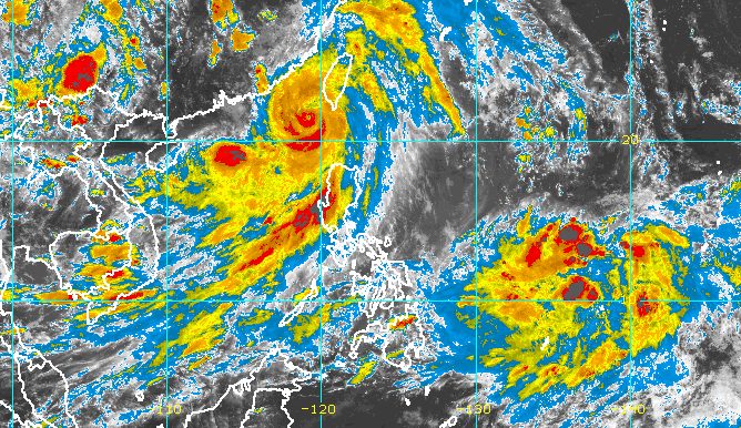
It was last spotted 280 kilometers west northwest of Itbayat, Batanes, moving west northwest at only 10 kilometers per hour from the previous 15 km/h.
Egay is heading for Fujian, China, where it could make landfall on Friday morning, July 28.
It continues to have maximum sustained winds of 150 km/h and gustiness of up to 185 km/h, but may weaken before hitting China.
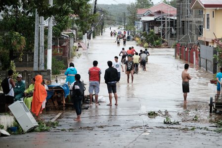
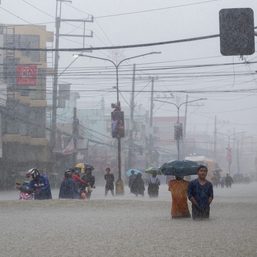
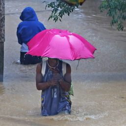
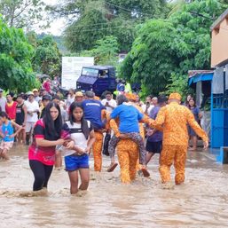
Batanes, the Babuyan Islands, and the northern part of Ilocos Norte still face rain from Egay on Thursday evening, the Philippine Atmospheric, Geophysical, and Astronomical Services Administration (PAGASA) said in a briefing past 5 pm.
Signal No. 2 has already been lifted, but Signal No. 1 is still in effect in the following areas, where strong winds persist:
- Batanes
- northern part of Apayao (Calanasan, Luna, Santa Marcela)
- Ilocos Norte
- northwestern part of Cagayan (Santa Praxedes, Claveria, Sanchez Mira, Pamplona, Abulug, Ballesteros) including Babuyan Islands
Egay made landfall twice in Cagayan province on Wednesday, July 26, with the first one in Fuga Island, Aparri, at 3:10 am, and the second one in Dalupiri Island, Calayan, at 9:30 am.
At its peak, Egay was a super typhoon with maximum sustained winds of 185 km/h. Before it hit land, it had already been downgraded to a typhoon, but was still a powerful tropical cyclone.

Meanwhile, the enhanced southwest monsoon is expected to bring monsoon rain to other areas in the Ilocos Region, Abra, Benguet, Zambales, Bataan, Occidental Mindoro, and the northern part of Palawan including Calamian and Cuyo islands.
Occasional rain will persist in Metro Manila, Calabarzon, the rest of the Cordillera Administrative Region, the rest of Cagayan Valley, the rest of Central Luzon, and the rest of Mimaropa.
Scattered rain showers and thunderstorms may hit Western Visayas as well.
Floods and landslides remain possible.
Gusty conditions due to the enhanced southwest monsoon will also continue in these areas:
Thursday, July 27
- Luzon, Western Visayas
Friday, July 28
- Batanes, Ilocos Region, Zambales, Bataan, Cavite, southern part of Quezon, Mimaropa, Bicol, Western Visayas
Saturday, July 29
- Zambales, Bataan, Cavite, Romblon, Kalayaan Islands, Antique
PAGASA issued another gale warning at 5 pm on Thursday due to the combined effects of Egay and the enhanced southwest monsoon. Waters are rough to very rough in the following seaboards:
- northern and western seaboards of Northern Luzon (Batanes, northern coast of Cagayan including Babuyan Islands, Ilocos Norte) – waves 3.1 to 6 meters high
- western seaboards of Luzon (Ilocos Sur, La Union, Pangasinan, Zambales, Bataan, Occidental Mindoro, Palawan including Kalayaan, Calamian, Cuyo, and Cagayancillo islands) – waves 3.1 to 6 meters high
- western and southern seaboards of Southern Luzon, eastern seaboards of Luzon (Metro Manila, Cavite, Batangas, Marinduque, Romblon, eastern coast of Cagayan, Isabela, Aurora, Quezon including Polillo Islands) – waves 2.8 to 4.5 meters high
- western seaboard of Visayas (Iloilo, Capiz, Aklan, Antique, Negros Occidental, Guimaras) – waves 2.8 to 4.5 meters high
- eastern seaboards of Southern Luzon and Visayas (Camarines Norte, Camarines Sur, Catanduanes, Albay, Sorsogon, Masbate including Ticao and Burias islands, Northern Samar) – waves 2.8 to 4.5 meters high
The weather bureau advised small vessels not to sail and larger vessels to be on alert for big waves.
Egay was the Philippines’ fifth tropical cyclone for 2023 and the second for July. PAGASA earlier estimated that two to four tropical cyclones would form inside or enter PAR during the month.
The weather bureau continues to monitor a tropical depression that developed outside PAR on Thursday.
It was located 1,470 kilometers east of Eastern Visayas on Thursday afternoon, moving west northwest at 20 km/h.
The tropical depression still has maximum sustained winds of 55 km/h and gustiness of up to 70 km/h.
It could enter PAR on Saturday evening, July 29, or Sunday morning, July 30, and would be given the local name Falcon. By then, it may already be a typhoon.
The initial forecast track shows the tropical cyclone could stay far from Philippine landmass, but PAGASA advised the public to keep monitoring updates. – Rappler.com
Add a comment
How does this make you feel?


There are no comments yet. Add your comment to start the conversation.